Modelling Dissolved Organic Carbon and Nitrogen in Streams and Rivers Across Atlantic Canada
|
|
|
- Lindsay Gordon
- 6 years ago
- Views:
Transcription

1 Modelling Dissolved Organic Carbon and Nitrogen in Streams and Rivers Across Atlantic Canada Marie France Jutras, Mina Nasr, Thomas Clair, Paul Arp Presented by: Marie France Jutras
2 Introduction OBJECTIVES: i) Introduce DOC 3 model to generate daily to annual stream water DOC and DON fluxes based on local hydrological and topographic controls ii) Introduce relationship between DOC and DON iii) Show how DOC 3 works for small, medium and large forest catchments in Atlantic Canada iv) And in connection with the forest hydrology model ForHyM (Balland et al., 2006)
 and helps the transport of these metals through a watershed.")
3 DOC & DON DOC Dissolved Organic Carbon Used to describe the thousands of dissolved compounds found in water that derive from organic materials (such as decomposed plant matter). Effects water chemistry and also forms complexes with trace metals (like Hg) and helps the transport of these metals through a watershed. DON Dissolved Organic Nitrogen Used to describe the dissolved organic level of nitrogen present in stream water. It differentiates from dissolved mineral nitrogen as DON focuses on the nitrogen such as amino acids, humic acids that flow with the water. Highest DOC concentrations typically occur summer to fall; lowest levels occur during winter and spring.
4 DOC 3 Approach Theoretical and empirical background observations (uplands): Net DOC production is proportional to rate of net primary production (NPP) and organic matter decay: both increase with increasing soil moisture and temperature DOC fluxes from forest litter increase with increasing DOC pool size within the forest floor Net DOC flux decreases drastically down the soil profile DOC concentrations in soil leachates are not strongly related to changing soil moisture conditions
5 DOC 3 Approach Theoretical and empirical background (wetland literature): Water flowing surficially through wet areas and wetlands provides most of the stream entering DOC Incoming water generally stays within the acrotelm Wetland flooding dilutes surface accumulated DOC


6 DOC3 Model used to: predict in stream colour, measure DOC & DON concentrations based on daily soil temperature and moisture changes as well as discharge.
7 DOC 3 Approach Dominant upland DOC flow (DOC U ): fairly quick trickle down towards groundwater pools and flow channels (flowpath 1) Within the soil, much of DOC U is lost or retained through (i) biological degradation (A layers), (ii)adsorption within the Al and Fe enriched B and BC layers. DOC U flow along the fractured bedrock surface is subject to pooling and delays Wetlands transfer DOC W directly into streams Overall basin to stream transfers depend on wet area (A W ) to basin area (A B ) ratios, as follows:
8 DOC 3 Approach DOC net flux (production & transfers) is sensitive to flow rates, substrate type and temperature Converting net transfer fluxes into concentrations yields
9 DOC 3 Approach DOC DOC concentrations: uplands wetlands (surface water based) DOC concentrations: uplands (ground water based) where represents the delay times k DOC the production coefficients and MC and T the soil moisture and temperature conditions Ea is the activation energy of the DOC production process
10 DOC 3 Approach DOC 3 model calibrations refer to adjusting k DOC (a basin specific DOC release parameter) and τ (lag time) for the upland and wetland flow paths Available for calibration: DOC concentration data, derived from weekly to biweekly grab sampling The calibration results were generalized by relating k DOC and τ to the area percentages of open water (lakes, ponds; A S ), wet areas per basin (A W ), and basin size (A B )
11 DOC 3 Approach Generalized DOC 3 Model formulation: all streams, all records R 2 = 0.48,and RMSE=3.8mgL 1 A S : open water surface per basin


12 DON Fluxes DON is directly related to stream exported dissolved organic carbon. DOC 3 modeling used for model export of organic nitrogen. Calculating DOC on a daily level Calculating DOC/DON fraction on a daily level / convert to DON Given the relationship between DOC and DOC, we can find direct DON exports on a yearly basis (kg/ha/yr) by using: Qstream = rate of stream discharge

13 ForHyM: to determine soil moisture, temeprature and flow rates Forest Hydrology Modelling (ForHyM) Input: daily rain, snow and air temperature Output run off interflow Base flow substrate moisture substrate temperature Depends on latitude, altitude, watershed area, slope, aspect, vegetation cover, soil profile. slope


14 Wet Areas Mapping through digital elevation modelling Cartographic depth to water determination <0.5 m pink (0 m) to red 0.5m Used to determine the wet area ratios used in DOC 3

 to 7 to")
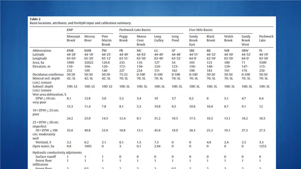
15 Study Areas New Brunswick 4 sites Nova Scotia 13 sites PEI 2 sites Newfoundland 7 sites 2 sites in Kejimkujik National Park used to calibrate the site (Moosepit Brook and Mersey River) Watershed areas ranged from 70 to 9.5 million ha Wet area % within basins varied from 3 to 10% (DTW<10 cm) to 7 to 30% (DTW<75cm)
16

17 Results Stream discharge and groundwater fluctuations Weather, soil and stream discharge conditions are regionally highly synchronized across the basins


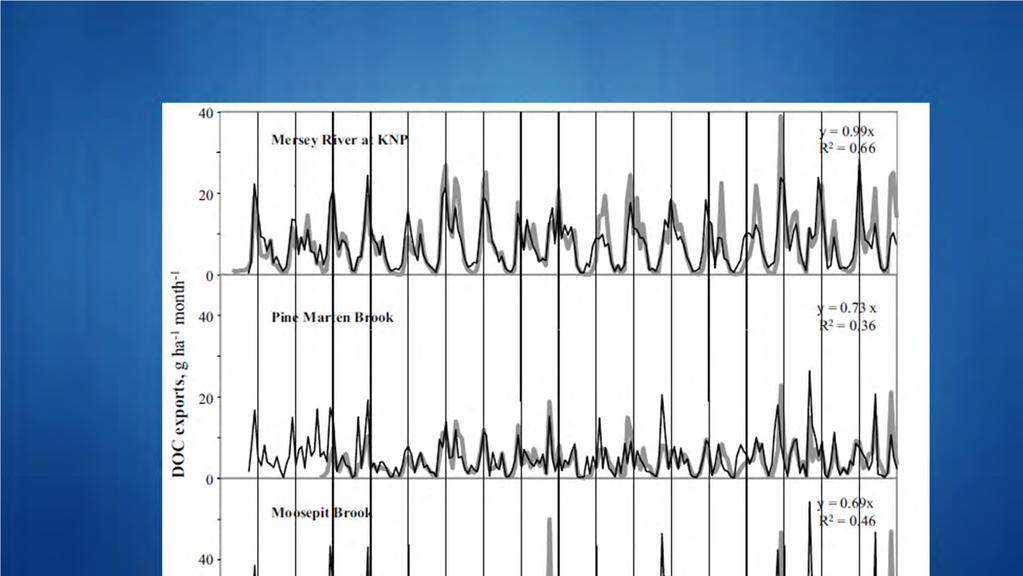
18 DOC results: good conformance between actual and best fitted results across basins
19 Results but note: DOC within small streams (Basin areas < 200 ha or so) lagged stream discharge by about a 1 2 day (this would need to be confirmed by way of daily DOC sampling) For the larger basin (Moosepit Brook, about 2000 ha) there was an additional lag of 9 days For the largest basin (Mersey River at KNP, about 20,000 ha), there was another delay of about 70 days.


20 Results For the large Mersey River basin, year by year variations in soil moisture deficits also varied according to seasonal soil moisture deficits: small deficits would produce the small streambased mid summer peaks, while large deficits would not. DOC concentrations were highly synchronized across small basins, esp. after accounting for basin sized DOC lags

21 Determining DOC fluxes: Modelled Actual
: actual")

22 Determining DOC fluxes (KNP basins): actual versus projected flux summary, monthly, annual
23 Results Note : Dissolved organic carbon (DOC, left) and N (DON, right) increase with increasing wet area coverage per basin, as formulated


24 DON & DOC Taking care of basin wide N inputs and outputs, including DON Note: most of atmospherically deposited N is either taken up by vegetation, and some of the incoming nitrate N is lost through denitirification. This particular loss increases across basins with increasing A W /A B ratios. Murphy et al Forest Ecology and Management.
25 Conclusion The DOC 3 model, + Forest Hydrology Model, + the digital derivation of open water and wet area percentages per watershed sets up a GIS framework for: modelling DOC and DON concentrations and fluxes from small to large watersheds main DOC and DON concentration and flux predictors: daily weather records (precipitation, air temperature) watershed area wet area per watershed (DTW.5m): DOC & DON, Nitrate N lake water area per watershed: DOC & DON Nitrate N open area per watershed: DOC & DON Nitrate N Note: Wet areas per watershed (DTW.5m) > wetland areas


26 Thank You Pockwock-Bowater Watershed Project
BAEN 673 / February 18, 2016 Hydrologic Processes
 BAEN 673 / February 18, 2016 Hydrologic Processes Assignment: HW#7 Next class lecture in AEPM 104 Today s topics SWAT exercise #2 The SWAT model review paper Hydrologic processes The Hydrologic Processes
LAND COVER EFFECTS ON WATERSHED HYDROLOGIC MEMORY. Jason P. Julian Robert H. Gardner
 LAND COVER EFFECTS ON WATERSHED HYDROLOGIC MEMORY Jason P. Julian Robert H. Gardner Oct 14, 2013 Watershed Hydrologic Memory Runoff = Precip ET Soil Moisture Groundwater Daily Discharge (m 3 /s) Runoff
Water Resources on PEI: an overview and brief discussion of challenges
 Water Resources on PEI: an overview and brief discussion of challenges Components: Components and links Atmospheric water Surface water (including glacial water) Groundwater Links: Precipitation (atm(
Hydrologic cycle, runoff process
 Hydrologic cycle, runoff process Motivation of hydrological modelling What happens at the catchment and in the stream when it rains? How does the increased/decreased runoff affect (not only) the landowners
The national-level nutrient loading estimation tool for Finland: Watershed Simulation and Forecasting System WSFS-Vemala
 The national-level nutrient loading estimation tool for Finland: Watershed Simulation and Forecasting System WSFS-Vemala Markus Huttunen, Finnish Environment Institute SYKE, HELCOM workshop on transboundary
Lecture 1 Integrated water resources management and wetlands
 Wetlands and Poverty Reduction Project (WPRP) Training module on Wetlands and Water Resources Management Lecture 1 Integrated water resources management and wetlands 1 Water resources and use The hydrological
Chapter 19. Nutrient Cycling and Retention. Chapter Focus. The hydrological cycle. Global biogeochemical cycles. Nutrient cycling
 Chapter Focus Chapter 19 Nutrient Cycling and Retention Nutrient cycling Phosphorus Nitrogen Carbon Water, Sulfur Decomposition Biotic effect on nutrient distribution and cycling Disturbance Global biogeochemical
Hydrology and Water Management. Dr. Mujahid Khan, UET Peshawar
 Hydrology and Water Management Dr. Mujahid Khan, UET Peshawar Course Outline Hydrologic Cycle and its Processes Water Balance Approach Estimation and Analysis of Precipitation Data Infiltration and Runoff
Hydrology Review, New paradigms, and Challenges
 Hydrology Review, New paradigms, and Challenges Intent quick introduction with emphasis on aspects related to watershed hydrochemistry and new paradigms Watershed / Catchment Definition Portion of landscape
EFFECTS OF WATERSHED TOPOGRAPHY, SOILS, LAND USE, AND CLIMATE ON BASEFLOW HYDROLOGY IN HUMID REGIONS: A REVIEW
 PROGRESS IN PHYSICAL GEOGRAPHY EFFECTS OF WATERSHED TOPOGRAPHY, SOILS, LAND USE, AND CLIMATE ON BASEFLOW HYDROLOGY IN HUMID REGIONS: A REVIEW KATIE PRICE 2011 Presented by: Jordan Martin Article Overview
Lecture 9A: Drainage Basins
 GEOG415 Lecture 9A: Drainage Basins 9-1 Drainage basin (watershed, catchment) -Drains surfacewater to a common outlet Drainage divide - how is it defined? Scale effects? - Represents a hydrologic cycle
Salt Dynamics in prairie wetlands under changing climate
 Salt Dynamics in prairie wetlands under changing climate Uri Nachshon Andrew Ireson Garth van der Kamp Howard Wheater Ryan Davies GIWS, University of Saskatchewan GIWS, University of Saskatchewan Environment
Introduction. Welcome to the Belgium Study Abroad Program. Courses:
 Introduction Welcome to the Belgium Study Abroad Program Courses: AGSM 335: Soil and Water Management BAEN 460: Principals of Environmental Hydrology BAEN 460 / AGSM 335 Combined lecture and HW sessions
2.3 Water Budget Data In Ontario
 2.3 Water Budget Data In Ontario Water budget data available for Ontario includes meteorologic data, hydrometric data and groundwater data. Geological and physiographical data provide information to describe
SNAMP water research. Topics covered
 SNAMP water research SNAMP water team UC Merced Topics covered Objectives, goals & overview What & why the water component of SNAMP Pre-treatment Observations Water Quality Water Quantity Modeling & Scenarios:
Ecosystems: Nutrient Cycles
 Ecosystems: Nutrient Cycles Greeks, Native Peoples, Buddhism, Hinduism use(d) Earth, Air, Fire, and Water as the main elements of their faith/culture Cycling in Ecosystems the Hydrologic Cycle What are
The Texas A&M University and U.S. Bureau of Reclamation Hydrologic Modeling Inventory (HMI) Questionnaire
 Questionnaire") The Texas A&M University and U.S. Bureau of Reclamation Hydrologic Modeling Inventory (HMI) Questionnaire May 4, 2010 Name of Model, Date, Version Number Dynamic Watershed Simulation Model (DWSM) 2002
The Texas A&M University and U.S. Bureau of Reclamation Hydrologic Modeling Inventory (HMI) Questionnaire May 4, 2010 Name of Model, Date, Version Number Dynamic Watershed Simulation Model (DWSM) 2002
Nutrients elements required for the development, maintenance, and reproduction of organisms.
 Nutrient Cycles Energy flows through ecosystems (one way trip). Unlike energy, however, nutrients (P, N, C, K, S ) cycle within ecosystems. Nutrients are important in controlling NPP in ecosystems. Bottom-up
ORCHARD GROUNDCOVER MANAGEMENT: LONG-TERM IMPACTS ON FRUIT TREES, SOIL FERTILITY, AND WATER QUALITY
 ORCHARD GROUNDCOVER MANAGEMENT: LONG-TERM IMPACTS ON FRUIT TREES, SOIL FERTILITY, AND WATER QUALITY Ian A. Merwin Department of Horticulture, Cornell University, Ithaca, NY, 14853 Summary Nitrogen (N)
Application of SWAT Model in land-use. change in the Nile River Basin: A Review
 Application of SWAT Model in land-use change in the Nile River Basin: A Review By: Marwa Ali, Okke Batelaan and Willy Bauwens 15-6-2011 Application of SWAT Model in land-use 1 change in the Nile River
Physiographic zones. and water quality
 Southland Physiographic zones Peat Wetlands Technical information Physiographic zones are part of the Water and Land 2020 & Beyond project that aims to maintain and improve water quality in the Southland
RESULTS. INTRODUcrlON
 INTRODUcrlON There is widespread concern that atmospheric sources of mercury (Hg) may be responsible for increasing Hg burdens in Lake Champlain (McIntosh 1994, Vasu and McCullough 1994) This has been
The Hydrological Cycle. Hydrological Cycle. Definition of Terms. Soils and Water, Spring Lecture 7, The Hydrological Cycle 1
 The Hydrological Cycle Water vapor helps warm up the earth Evaporation+Transpiration Chemical Spill Runoff To Oceans Water potential, atmosphere Hydrological Cycle Transpiration, T Atmospheric pool Interception
MODELING SEDIMENT AND PHOSPHORUS YIELDS USING THE HSPF MODEL IN THE DEEP HOLLOW WATERSHED, MISSISSIPPI
 MODELING SEDIMENT AND PHOSPHORUS YIELDS USING THE HSPF MODEL IN THE DEEP HOLLOW WATERSHED, MISSISSIPPI Jairo Diaz-Ramirez, James Martin, William McAnally, and Richard A. Rebich Outline Background Objectives
GUIDE TO THE DEVELOPMENT OF A MINING AND RECLAMATION PLAN IN NEW BRUNSWICK
 PROVINCE OF NEW BRUNSWICK DEPARTMENT OF ENERGY AND RESOURCE DEVELOPMENT Minerals and Petroleum Development Branch GUIDE TO THE DEVELOPMENT OF A MINING AND RECLAMATION PLAN IN NEW BRUNSWICK Guide to the
Niche and Habitat a species plays in a community. What it does all
 Ecosystem Dynamics What is ecology? Study of the interactions between parts of the environment Connections in nature Abiotic: soil comp. Biotic: and Abiotic and Biotic factors factors in the environment
Great Lakes Update. Volume 189: 2013 January through June Summary
 Great Lakes Update Volume 189: 2013 January through June Summary The U.S. Army Corps of Engineers (USACE) tracks the water levels of each of the Great Lakes. This report highlights hydrologic conditions
Ministry of Agriculture and Rural Development. Fight against soil erosion and watershed management
 Ministry of Agriculture and Rural Development Fight against soil erosion and watershed management - The activity of watershed management in Romania: - is a very close to the forestry field - it contributes
NATURAL FEATURES, LAND SUITABILITY FOR DEVELOPMENT AND DEVELOPMENT CONCERNS
 East Central Wayne County Comprehensive Plan - Natural Features, Land Suitability Page 170 NATURAL FEATURES, LAND SUITABILITY FOR DEVELOPMENT AND DEVELOPMENT CONCERNS Introduction The residents of East
Water Balance Methodology
 Water Balance Methodology Integrating the Site with the Watershed and the Stream March 2012 An initiative under the umbrella of the Water Sustainability Action Plan for British Columbia Water Balance Methodology
GIS Applications in Water Resources Engineering
 King Fahd University of Petroleum & Minerals City & Regional Planning Department Introduction to Geographic Information Systems Term Paper Presentation GIS Applications in Water Resources Engineering Prepared
Inside of forest (for example) Research Flow
 Research Flow") Study on Relationship between Watershed Hydrology and Lake Water Environment by the Soil and Water Assessment Tool (SWAT) Shimane University Hiroaki SOMURA Watershed degradation + Global warming Background
Study on Relationship between Watershed Hydrology and Lake Water Environment by the Soil and Water Assessment Tool (SWAT) Shimane University Hiroaki SOMURA Watershed degradation + Global warming Background
Protecting Utah s Water Resources. Nutrient Issues
 Protecting Utah s Water Resources Nutrient Issues Nutrient Issues Questions What are they? Why are they important? Nationally Locally What are the impact on my community Costs Timing What are Nutrients?
East Maui Watershed Partnership Adapted from Utah State University and University of Wisconsin Ground Water Project Ages 7 th -Adult
 INTRODUCTION What is groundwater? Water contained in saturated soil and rock materials below the surface of the earth. It is not NEW water, but is recycled water through the hydraulic cycle. The source
Water balance and observed flows in the Anllóns river basin (NW Spain).
.") Water balance and observed flows in the Anllóns river basin (NW Spain). M.ERMITAS 1 RIAL RIVAS, MANUEL ALÍ ÁLVAREZ ENJO 2 & FRANCISCO DÍAZ-FIERROS VIQUEIRA 3 Departamento de Edafoloxía e Química Agrícola,
Water balance and observed flows in the Anllóns river basin (NW Spain). M.ERMITAS 1 RIAL RIVAS, MANUEL ALÍ ÁLVAREZ ENJO 2 & FRANCISCO DÍAZ-FIERROS VIQUEIRA 3 Departamento de Edafoloxía e Química Agrícola,
Appendix 12. Pollutant Load Estimates and Reductions
 Appendix 12. Pollutant Load Estimates and Reductions A pollutant loading is a quantifiable amount of pollution that is being delivered to a water body. Pollutant load reductions can be calculated based
CHAPTER FIVE Runoff. Engineering Hydrology (ECIV 4323) Instructors: Dr. Yunes Mogheir Dr. Ramadan Al Khatib. Overland flow interflow
 Instructors: Dr. Yunes Mogheir Dr. Ramadan Al Khatib. Overland flow interflow") Engineering Hydrology (ECIV 4323) CHAPTER FIVE Runoff Instructors: Dr. Yunes Mogheir Dr. Ramadan Al Khatib Overland flow interflow Base flow Saturated overland flow ١ ٢ 5.1 Introduction To Runoff Runoff
Engineering Hydrology (ECIV 4323) CHAPTER FIVE Runoff Instructors: Dr. Yunes Mogheir Dr. Ramadan Al Khatib Overland flow interflow Base flow Saturated overland flow ١ ٢ 5.1 Introduction To Runoff Runoff
Scientific insights on emerging groundwater concerns in Prince Edward Island Atlantic Agrology Workshop, Stanley Bridge Resort, PEI 21 July 2014
 Scientific insights on emerging groundwater concerns in Prince Edward Island Atlantic Agrology Workshop, Stanley Bridge Resort, PEI 21 July 2014 Yefang Jiang Agriculture and Agri-Food Canada Yefang.jiang@agr.gc.ca
Issue paper: Aquifer Water Balance
 Issue paper: Aquifer Water Balance 1. Introduction And Background 1.1. Purpose and Scope The population in Kitsap County has grown rapidly in recent years and is expected to increase substantially in the
Screening Methodology for Calculating ANC Change to High Elevation Lakes USDA Forest Service Rocky Mountain Region January, 2000
 Screening Methodology for Calculating ANC Change to High Elevation Lakes USDA Forest Service Rocky Mountain Region January, 2000 Introduction The purpose of this screening methodology is provide a simplistic
Hydrologic Cycle. Water Availabilty. Surface Water. Groundwater
 Hydrologic Cycle Hydrologic ydoogccyce cycle Surface Water Groundwater Water Availabilty 1 Hydrologic Cycle Constant movement of water above, on, and, below the earth s surface (Heath) Endless circulation
Representing the Integrated Water Cycle in Community Earth System Model
 Representing the Integrated Water Cycle in Community Earth System Model Hong-Yi Li, L. Ruby Leung, Maoyi Huang, Nathalie Voisin, Teklu Tesfa, Mohamad Hejazi, and Lu Liu Pacific Northwest National Laboratory
Watershed Characterization, Monitoring and Measurements
 Watershed Characterization, Monitoring and Measurements Intent - highlight key approaches to watershed monitoring using the Fair Hill Study watershed as an example Watershed characterization and monitoring
Technical Memorandum. 1.0 Introduction
 Technical Memorandum To: Jennifer Saran and Christie Kearney, Poly Met Mining, Inc. Project: 23/69-0862.12 100 001 c: Keith Hanson and Tina Pint, Barr Engineering Co. Disclaimer: This is a working document.
Urbanization effects on the hydrology of the Atlanta area, Georgia (USA)
") 14/06/01 Impact of Human Activity on Groundwater Dynamics (Proceedings of a symposium held during the Sixth IAHS Scientific Assembly at Maastricht, The Netherlands, July 2001). IAHS Publ. no. 269, 2001.
14/06/01 Impact of Human Activity on Groundwater Dynamics (Proceedings of a symposium held during the Sixth IAHS Scientific Assembly at Maastricht, The Netherlands, July 2001). IAHS Publ. no. 269, 2001.
Watercourses and Wetlands and Agricultural Activities
 Watercourses and Wetlands and Agricultural Activities Watercourses and regulated wetlands can be found throughout New Brunswick, including on agricultural lands. The Clean Water Act defines a watercourse
From the cornbeltto the north woods; understanding the response of Minnesota. Chris Lenhart Research Assistant Professor BBE Department
 From the cornbeltto the north woods; understanding the response of Minnesota watersheds to climate change Chris Lenhart Research Assistant Professor BBE Department 1. Background Differential response of
Lagoons Operation and Management in New Brunswick
 Lagoons Operation and Management in New Brunswick Lagoons Provide secondary treatment to domestic wastewater by the action of bacteria stabilizing the organic matter in the wastewater. Benefits of lagoons:
The Fourth Assessment of the Intergovernmental
 Hydrologic Characterization of the Koshi Basin and the Impact of Climate Change Luna Bharati, Pabitra Gurung and Priyantha Jayakody Luna Bharati Pabitra Gurung Priyantha Jayakody Abstract: Assessment of
Afternoon Lecture Outline
 Afternoon Lecture Outline 1. Northern Prairies watershed hydrology 2. Solute mass balance in lakes and ponds 3. Simple mass balance simulation using MS Excel 4. Effects of sediment-water exchange on lake
M.L. Kavvas, Z. Q. Chen, M. Anderson, L. Liang, N. Ohara Hydrologic Research Laboratory, Civil and Environmental Engineering, UC Davis
 Assessment of the Restoration Activities on Water Balance and Water Quality at Last Chance Creek Watershed Using Watershed Environmental Hydrology (WEHY) Model M.L. Kavvas, Z. Q. Chen, M. Anderson, L.
Wetland Monitoring. City of Edmonton. Edmonton Wetlands Workshop December 4-5, 2013
 Wetland Monitoring City of Edmonton Edmonton Wetlands Workshop December 4-5, 2013 City of Edmonton Presentation Outline Kennedale Wetland Water Quality Sediment removal Vegetation management Biological
Re-plumbing Roadside Ditch Networks
 Re-plumbing Roadside Ditch Networks Ditches Improving management to reduce flooding, water pollution, and in-stream erosion and habitat degradation Rebecca Schneider Dept. Natural Resources Cornell University,
M.L. Kavvas, Z. Q. Chen, M. Anderson, L. Liang, N. Ohara Hydrologic Research Laboratory, Civil and Environmental Engineering, UC Davis
 Assessment of the Restoration Activities on Water Balance and Water Quality at Last Chance Creek Watershed Using Watershed Environmental Hydrology (WEHY) Model M.L. Kavvas, Z. Q. Chen, M. Anderson, L.
 Good Morning! Bruce Gilman Department of Environmental Conservation and Horticulture Finger Lakes Community College 3325 Marvin Sands Drive Canandaigua, New York 14424 585-785- 1255 gilmanba@flcc.edu Northern
Air & Water Lesson 2. Chapter 6 Conserving Our Resources
 Air & Water Lesson 2 Chapter 6 Conserving Our Resources Objectives Summarize the importance of air. Describe the water cycle. Main Idea Living things use air and water to carry out their life processes.
Ducks Unlimited Canada. Conserving Canada s Wetlands
 Ducks Unlimited Canada Conserving Canada s Wetlands ESANS November 25rd, 2015 Wade Lewis, Head Restoration and Client Services Ducks Unlimited Canada Employee for 12 years Original Concept of Ducks Unlimited
Measuring discharge. Climatological and hydrological field work
 Measuring discharge Climatological and hydrological field work 1. Background Discharge (or surface runoff Q s) refers to the horizontal water flow occurring at the surface in rivers and streams. It does
7 Section 7: Land to Water
 7 Section 7: Land to Water 7.1 Introduction As discussed in Section 1, the multiple modeling approach permits P6 to represent processes on a finer scale than previous versions of the Watershed Model. Table
Hydrology and Water Quality. Water. Water 9/13/2016. Molecular Water a great solvent. Molecular Water
 Hydrology and Water Quality Water Molecular Water Exists as an equilibrium But equilibrium altered by what is dissolved in it Water Molecular Water a great solvent In reality, water in the environment
Cycles of Ma,er. Lesson Overview. Lesson Overview. 3.4 Cycles of Matter
 Lesson Overview Cycles of Ma,er Lesson Overview 3.4 Cycles of Matter THINK ABOUT IT A handful of elements combine to form the building blocks of all known organisms. Organisms cannot manufacture these
Rock Creek Floodplain Analysis
 Rock Creek Floodplain Analysis www.co.washington.or.us By Jon Franczyk 1996 Flood, www.co.washington.or.us 1996 Flood, www.co.washington.or.us Project Outline Project Goals Introduction Background Study
Ecosystems Section 1 What Is an Ecosystem? Objectives Distinguish Describe Sequence Interactions of Organisms and Their Environment Ecology Habitat
 Name Period Ecosystems Section 1 What Is an Ecosystem? Objectives Distinguish an ecosystem from a community. Describe the diversity of a representative ecosystem. Sequence the process of succession. Interactions
Modelling of inorganic N load from anthropogenic sources in a boreal river basin
 Geophysical Research Abstracts, Vol. 7, 07161, 2005 SRef-ID: 1607-7962/gra/EGU05-A-07161 European Geosciences Union 2005 Modelling of inorganic N load from anthropogenic sources in a boreal river basin
VI. WATER QUALITY MODELING
 VI. WATER QUALITY MODELING As was mentioned previously in Chapter V, the Hamblin Pond/Jehu Pond and Quashnet River sub-systems of Waquoit Bay were a part of the larger hydrodynamic model of the Waquoit
Lake Simcoe Watershed Climate Change Vulnerability Assessment: Water Quantity and Quality
 Lake Simcoe Watershed Climate Change Vulnerability Assessment: Water Quantity and Quality Presentation to A.D. Latornell Conservation Symposium November 16, 2011 Eleanor Stainsby & Scott MacRitchie Vulnerability
WMS Tools For Computing Hydrologic Modeling Parameters
 WMS Tools For Computing Hydrologic Modeling Parameters Lesson 9 9-1 Objectives Use the drainage coverage as a basis for geometric parameters as well as overlaying coverages to compute important hydrologic
MERGANSER - An empirical model to estimate fish and loon Hg in New England lakes
 MERGANSER - An empirical model to estimate fish and loon Hg in New England lakes DTMC webinar, September 6, 2011 Project Team Building MERGANSER 1. Choose base map: National Wetlands Inventory (NWI) 2.
Ch. 5 - Nutrient Cycles and Soils
 Ch. 5 - Nutrient Cycles and Soils What are Nutrient (biogeochemical) Cycles? a process by which nutrients are recycled between living organisms and nonliving environment. The three general types of nutrient
WATERSHED. Maitland Valley. Report Card 201
 Maitland Valley WATERSHED Report Card 201 The Maitland Valley Conservation Authority has prepared this report card as a summary on the state of our forests, wetlands, surface water, and ground water resources.
Stanley J. Woodcock, Michael Thiemann, and Larry E. Brazil Riverside Technology, inc., Fort Collins, Colorado
 7.5 FRASER RIVER EXTENDED STREAMFLOW PREDICTION SYSTEM Stanley J. Woodcock, Michael Thiemann, and Larry E. Brazil Riverside Technology, inc., Fort Collins, Colorado Esther Vincent and Andy Pineda * Northern
Gas Guzzlers. Biological Pump
 Gas Guzzlers Biological Pump Aquatic Biodiversity Chapter 8 Coral Reefs Open Ocean Deep Sea Marine equivalent of tropical rain forests Habitats for one-fourth of all marine species Coral polyps, which
INTRODUCTION cont. INTRODUCTION. What is Impervious Surface? Implication of Impervious Surface
 Mapping Impervious Surface Changes In Watersheds In Part Of South Eastern Region Of Nigeria Using Landsat Data By F. I. Okeke Department of Geoinformatics and Surveying, University of Nigeria, Enugu Campus
Comparison of three flood runoff models in the Shonai River basin, Japan
 Comparison of three flood runoff models in the Shonai River basin, Japan TOSHIHARU KOJIMA Division of Fluvial and Marine Disasters, Disaster Prevention Research Institute, Kyoto University, Gokasho, Uji,
Uncertainty in Hydrologic Modelling for PMF Estimation
 Uncertainty in Hydrologic Modelling for PMF Estimation Introduction Estimation of the Probable Maximum Flood (PMF) has become a core component of the hydrotechnical design of dam structures 1. There is
Nutrient Loading: NAWQA Regional SPARROW model
 Nutrient Loading: NAWQA Regional SPARROW model Pee Dee River Basin and Winyah Bay Estuary Waccamaw Water Quality Data Conference Wednesday, September 19, 2013 Celeste Journey, Water-Quality Specialist
Stormwater Treatment Wetlands
 Florida Chamber Summer School July, 2014 Stormwater Treatment Wetlands Chris Keller, P.E. Wetland Solutions, Inc. Why Wetlands? Wetlands are the natural stormwater management systems in the landscape Wetlands
The role of freshwater ecosystems in carbon and nutrient cycling on the catchment scale. LSUE external launch Steven Bouillon
 The role of freshwater ecosystems in carbon and nutrient cycling on the catchment scale LSUE external launch Steven Bouillon Why are freshwater ecosystems important? CO 2 efflux 0.8 Pg C y -1 ~1.9 Pg C
H1: Watershed land use and stream bank morphology determine sediment load and P- N speciation sensitive to timing, frequency, and intensity of rain-sn
 Question 1: What is the relative importance of endogenous inlake processes (e.g. internal loading, ice cover, hydrodynamics) versus exogenous to-lake processes (e.g. land use change, snow/rain timing,
National Wildlife Federation Eco-Schools USA
 ATMOSPHERE GLOBE student data within the Atmosphere investigation aids scientific understanding of spatial gaps in air temperature and precipitation coverage by weather monitoring stations, important data
Climate Change in the Columbia Basin. Stephanie Smith Manager of Hydrology, BC Hydro
 Climate Change in the Columbia Basin Stephanie Smith Manager of Hydrology, BC Hydro June 20, 2017 Outline Climate change in the Columbia River basin What has happened? What could happen? What can we do
Sunset Circle Vegetated Swale and Infiltration Basin System Monitoring Report: Rainy Seasons and
 Sunset Circle Vegetated Swale and Infiltration asin System Monitoring Report: Rainy Seasons 2012-13 and 2013-14 bstract Site Summary Project Features Sunset Circle Vegetated swales and infiltration basins
Chapter 3 Physical Factors Affecting Runoff
 Chapter 3 Physical Factors Affecting Runoff Copyright 2003 David G Tarboton, Utah State University CHAPTER 3: PHYSICAL FACTORS AFFECTING RUNOFF The general climatic regime controls the total volume of
Air and Air Pollution Control Last changed: 4/04/11
 http://www.umweltbundesamt.de/luft-e/eintraege-wirkungen/versauerung.htm Air and Air Pollution Control Last changed: 4/04/11 Air pollutant inputs Deposition Air pollutants not only have direct effects
Monitoring Stormwater Best Management Practices: Why Is It Important and What To Monitor
 Monitoring Stormwater Best Management Practices: Why Is It Important and What To Monitor Scott D. Struck, Ph.D. US EPA, Urban Watershed Management Branch New Jersey Water Monitoring Workshop 4/20/2006
Flood forecasting model based on geographical information system
 doi:10.5194/piahs-368-192-2015 192 Remote Sensing and GIS for Hydrology and Water Resources (IAHS Publ. 368, 2015) (Proceedings RSHS14 and ICGRHWE14, Guangzhou, China, August 2014). Flood forecasting model
Hydrologic Modeling Overview
 Hydrologic Modeling Overview Chuck Downer, PhD, PE Hydrologic Systems Branch Coastal and Hydraulics Laboratory Engineer Research and Development Center Vicksburg, Mississippi Hydrologic processes Hydrologic
Interpreting Nitrate Concentration in Tile Drainage Water
 Agronomy Guide AY-318-W SOILS (TILLAGE) Sylvie Brouder, Brenda Hofmann, Eileen Kladivko, Ron Turco, Andrea Bongen, Purdue University Department of Agronomy; Jane Frankenberger, Purdue University Department
Overview of the Surface Hydrology of Hawai i Watersheds. Ali Fares Associate Professor of Hydrology NREM-CTAHR
 Overview of the Surface Hydrology of Hawai i Watersheds Ali Fares Associate Professor of Hydrology NREM-CTAHR 5/23/2008 Watershed Hydrology Lab 1 What is Hydrology? Hydrology is the water science that
Water cycles through ecosystems.
 Water cycles through ecosystems. Water is stored on Earth s surface in lakes, rivers, and oceans. Water is found underground, filling the spaces between soil particles and cracks in rocks. Large amounts
Trends in Illinois River Streamflow and Flooding
 Trends in Illinois River Streamflow and Flooding H. Vernon Knapp, Interim Director Center for Watershed Science Illinois State Water Survey Institute of Natural Resource Sustainability University of Illinois
Hydrology 101. Impacts of the Urban Environment. Nokomis Knolls Pond Summer June 2008
 Hydrology 101 Nokomis Knolls Pond Summer 2002 Impacts of the Urban Environment Hydrologic Cycle; What is it? Geography, Topography, Geology, Land Cover and Climate determine the Amount and Behavior of
Biological Transformations of Refuse
 Biological Transformations of Refuse Aerobic decomposition Organic matter + O 2 CO 2 + H 2 O + NH 3 + Heat NH 3 + O 2 NO 3 This is composting - air is supplied to refuse Anaerobic decomposition Organic
Unit 2: Weather Dynamics Chapter 1: Hydrological Cycle
 UNIT 2 Chapter 1: Inquiring about Weather Unit 2: Weather Dynamics Chapter 1: Hydrological Cycle Science 10 Mrs. Purba Importance of H 2 O From the beginning of time when water first appeared, it has been
USING ARCSWAT TO EVALUATE EFFECTS OF LAND USE CHANGE ON WATER QUALITY. Adam Gold Geog 591
 USING ARCSWAT TO EVALUATE EFFECTS OF LAND USE CHANGE ON WATER QUALITY Adam Gold Geog 591 Introduction The Soil and Water Assessment Tool (SWAT) is a hydrologic transport model with an objective to predict
5.5 Improving Water Use Efficiency of Irrigated Crops in the North China Plain Measurements and Modelling
 183 5.5 Improving Water Use Efficiency of Irrigated Crops in the North China Plain Measurements and Modelling H.X. Wang, L. Zhang, W.R. Dawes, C.M. Liu Abstract High crop productivity in the North China
Municipal Stadium Wetland
 W A T E R S H E D F A C T S Total watershed area 140 mi 2 Average annual rainfall 38 in Average annual temperature 58 F Elevation Max 1321 ft Min 899 ft C. J. Brown Reservoir controls flow from 83 mi 2
Afternoon Lecture Outline. Northern Prairie Hydrology
 Afternoon Lecture Outline 1. Northern Prairies watershed hydrology 2. Solute mass balance in lakes and ponds 3. Simple mass balance simulation using MS Excel 4. Effects of sediment-water exchange on lake
MoRE Results and Modifications
 MoRE Results and Modifications Stephan Fuchs, Stephan Hilgert, Tatyana Rogozina, Ramona Wander Simon Höllering, Jürgen Ihringer und Ulrike Scherer INSTITUTE FOR WATER AND RIVER BASIN MANAGEMENT, DEPARTMENT
an ecosystem is a community of different species interacting with one another and with their nonliving environment of matter and energy
 1 Ecocsystems: Energy Flow and Materials Cycling 2 EVPP 111 Lecture Dr. Largen Spring 2004 Energy Flow and Matter Cycling Energy flow s through ecosystems ecosystems global energy budget physical laws