SENTINEL 2 WATER QUALITY APPLICATIONS IN SOUTH AFRICA: ASSESSMENT OF USER NEEDS AND POTENTIAL ALGORITHMIC APPROACHES
|
|
|
- Josephine York
- 6 years ago
- Views:
Transcription


1 SENTINEL 2 WATER QUALITY APPLICATIONS IN SOUTH AFRICA: ASSESSMENT OF USER NEEDS AND POTENTIAL ALGORITHMIC APPROACHES Stewart Bernard, Mark Matthews, Derek Griffith, Lisl Robertson-Lain, Hayley Evers-King May 2014, Sentinel 2 for Science, ESRIN
2 Earth Observation and Water Quality: The South African User Need On current trends, South Africa is headed for a crisis of water security and quality that will hamper the country s social and economic development, Centre for Development and Enterprise 2010 "Any decrease in the quality, and therefore usability, of water in South Africa by 1% may result in the loss of 200,000 jobs, a drop of 5,7% in disposable income per capita, and an increase of 5% or R18,1 billion in government spending, PlusEconomics/UASA (2010) Remote sensing based water quality measurements can play a major role in better managing the vital national water resource. Critical in a South African context is the need for water quality observations in small and typically eutrophic water bodies. This need is not currently met by existing earth observation sensors and programmes. South African Department of Water Affairs


3 South African User Requirements for EO Water Quality Table 1. Summary of key user needs for water quality products, driven primarily by the National Eutrophication Monitoring Programme (NEMP) of the Resource Quality Services and Water Management System of the South African Department of Water Affairs.
4 First order study of two algorithms to simulated MSI and OLCI data for Case 1 eutrophic waters Two approaches were taken to make a preliminary assessment of the potential performance of Sentinel 2/MSI and Sentinel 3/OLCI for South African inland water types. 1.Combined Hydrolight/MODTRAN modelling approach to derive hyperspectral remotesensing reflectance R rs and TOA radiance L TOA for a range of water with increasing algal biomass in Case 1 conditions and atmosphere types, and the multi-spectral R rs and L TOA subset to MSI and OLCI bands. R rs data have 10% random noise added to simulate atmospherically corrected L2 data. 2.The second approach used the MERIS bottom-of-rayleigh reflectance & match-up data set used for the original MPH derivation (Matthews et al 2012) and produced an approximate simulation of the 30 nm wide MSI band centred at 665 nm by averaging the MERIS bands centred at 665 and 681 nm. Application of MPH and MPH-S2 (665, 705, 865 nm line height type algorithm) applied to top-of-atmosphere & bottom-of-rayleigh data from 1. and 2. Application of Equivalent Algal Population semi-analytical inversion algorithm to simulated R rs + 10% noise data


5 New models for eutrophic waters & phytoplankton type Robertson-Lain, Bernard and Evers- King, Optics Express, 2014 (forthcoming)
6 New models for eutrophic waters & phytoplankton type Nadir viewing TOA spectral ranges for three typical target cases: A) Moderate biomass diatom-type waters with a pronounced fluorescence peak at ± 683 nm B) High biomass red tide type waters with pronounced reflectance peak at ± 709 nm C) Surface scum of cyanobacteria with vegetation type spectra D) The relative contribution of the water signal to that measured at TOA, clearly demonstrating the need for the suite of narrow bands in the nm region.
 for Case 1 waters with Chl a = 8.")
 and Sentinel 3/OLCI bands (right) for Case 1 waters with Chl a = 92 mg m-3, highlighting relative")
7 Example modelled eutrophic data for MSI and OLCI Hyperspectral remote-sensing reflectance and extracted Sentinel 2/MSI bands (left) and Sentinel 3/OLCI bands (right) for Case 1 waters with Chl a = 8.7 mg m -3 highlighting relative spectral coverage for mesotrophic waters with prominent fluorescence at ± 685 nm Hyperspectral remote-sensing reflectance and extracted Sentinel 2/MSI bands (left) and Sentinel 3/OLCI bands (right) for Case 1 waters with Chl a = 92 mg m-3, highlighting relative spectral coverage for a highly eutrophic water type with prominent backscattering/absorption related peak at ± 705 nm.


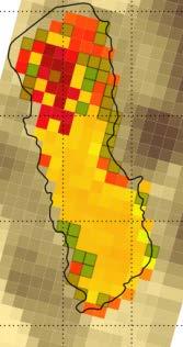
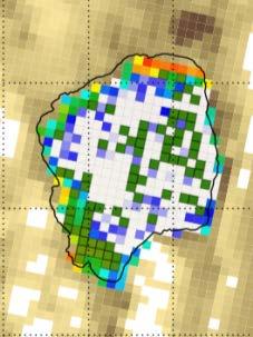
8 Algorithms: MPH Chlorophyll-a product Objective: Operational trophic status determination Matthews et al., 2012 Maximum Peak Height (MPH) algorithm (Matthews et al., 2012) Scu m Source: MERIS FR data Temporal resolution: 3/5 days Availability: 2002 to 04/2012 Spatial scale: 300 m Range: 1 to 1000 mg/m 3 Accuracy: +- 30% Sterkfontein Heyshope Vaal Hartbeespoort Oligotrophic Chl < 10 Mesotrophic 10 < Chl <20 Eutrophic 20 < chl < 30 Hypertrophic Chl > 30 Validated? Yes. Using DWA data, global dataset. Matthews et al 2012


 was validated by product.")


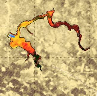
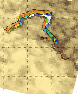
9 Algorithms: MPH Cyanobacteria product Objective: Health, water treatment, early warnings, toxicity warnings. WARNING: CYANOBACTERIA DETECTED! Dark green = Cyano scum White = cyanobacteria Black = other water Winter cyano bloom in Midmar in 2005 identified by Oberholster and Botha (2007) was validated by product. VALIDATE! Surface scum Description: Detects cyanobacteria for chla > +-20 mg/m3 Source: MERIS FR data Temporal resolution: 3/5 days Availability: 2002 to 2012/04 Spatial scale: 300 m Validated? Using local and global case studies. Matthews et al 2012


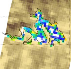
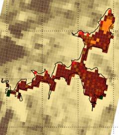
10 Algorithms: MPH Floating vegetation / macrophytes product Reflectance Typical vegetation spectrum Objectives: Vegetation clearing, open water management, invasives control Source: MERIS FR data Floating vegetation / macrophytes Temporal product Wavelength resolution: 3/5 days Eichhornia crassipes A perennial aquatic plant, free-floating or anchored in shallow water, usually 10-20cm high but up to 1m when growing in dense mats. It has dark shiny green leaves in rosettes with distinctive, swollen, bladder-like petioles. Pale violet or blue flowers in 8-10 flowered spikes appear from November to April. This aquatic plant invades dams and slow-moving rivers. Magenta = floating macrophytes Availability: 2002 to 2012/04 Spatial scale: 300 m Validated: Using local and global case studies. Vaal Dam Matthews et al 2012


11 Albert Falls Barberspan Bloemhof Brandvlei Bronkhorstspruit Chrissiesmeer Darlington Erfenis Fairview Flag Boshielo Gariep Goedertrou Grassridge Grootdraai Hartbeespoort Heyshope Inanda Jericho 50 RESERVOIRS Klipvoor Krugersdrift Kuhlange Kalkfontein Koppies Kwena Lake Msingazi Lake Sibayi Loskop Lubisi Midmar Mokolo Ncora Allemanskraal Ntshingwayo Pongola Roodekoppies Rustfontein Spioenkop Spitskop Theewaterskloof Tzaneen Sterkfontein Umtata Vaal Vaalkop Vanderkloof Voelvlei Witbank Woodstock Xonxa Zaaihoek


.")
 10 years of")

12 Algorithm application: decadal characterisation of the trophic status of the inland water resource Loskop Dam. Time series for Chl and area coverage for cyanobacteria and surface scum for Loskop Dam (upper). Deconvolution of Chl into seasonal signal, showing anomalies and yearly averages (lower) 10 years of MPH algorithm and MERIS FR data applied to 50 South African freshwater reservoirs, providing decadal analysis of eutrophication and cyanobacterial occurence Mark Matthews, PhD, awarded May 2014 in prep RSE, SAJS


 Evers-King, Bernard, Robertson-Lain, & Probyn,")
13 Algorithms: Equivalent Algal Population Chlorophyll a product A semi-analytical model capable of providing algal size/population descriptors used here to assess relative performance of S2 and S3 for algorithms requiring all available spectral bands (and therefore full atmospheric correction) Evers-King, Bernard, Robertson-Lain, & Probyn, Optics Express, 2014
14 Simulated first order MPH performance S2 & S3 Preliminary performance of MPH algorithm for OLCI bands from modelled TOA as expected looks good for Case 1 waters & highlights overly simplistic modelling. Preliminary performance of MPH algorithm for MSI bands (665, 705, 865 nm) from modelled TOA. Looks very promising and width of 665 nm band appears not to be an issue Preliminary performance of MPH algorithm for MSI bands (665, 705, 865 nm) from MERIS averaging. Looks very promising, will need dynamic scaling flags in absence of 620 nm band
15 Simulated first order EAP performance S2 & S3 Correlation between [Chl a] used in the generation of the simulated data and those returned by the EAP algorithm for Sentinel 2 simulated data (blue circles) and Sentinel 3 simulated data (red circles). For comparison, an Algal 1 type approach has also been applied to both Sentinel 2 and Sentinel 3 simulated data, with the 510/560 ratio excluded from the Sentinel 2 application. [Chl a] predicted by the EAP algorithm using the Sentinel 2 and 3 bands. Relatively good performance is achieved for both sensors, despite the large range covered by the simulated data set. Overestimation is seen at lower biomass (<3 mg m 3 ), where IOPS are not sufficiently constrained - performance from Algal 1 type approaches is better at these biomass ranges
.")
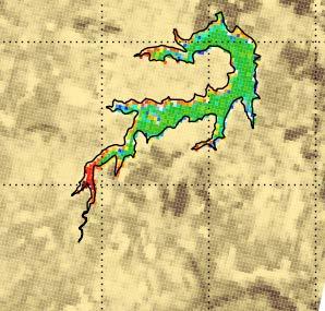
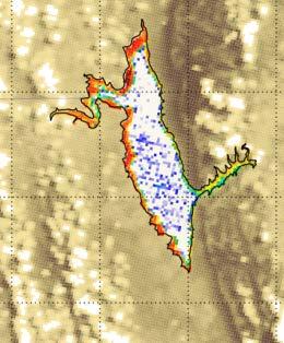
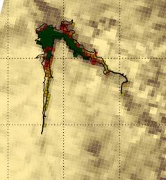
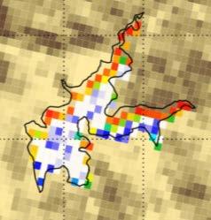
16 Adjacency/Atmospheric considerations The MERIS MPH algorithm applied to a clear, high altitude oligotrophic reservoir (Sterkfontein) in the mountainous region of the Drakensberg, South Africa. The chl-a image is on the left and the flags are shown on the right. Red = adjacency flagged, pink = vegetation (shoreline). Adjacency effects on algorithm products will depend on water body size, trophic state and spectral nature of surrounding land. Small, oligotrophic water bodies are likely to be worst affected Some consideration needs to be made of the relative benefits of bottom of Rayleigh vs aerosol corrected products and associated algorithm choice/performance obviously dependent on user needs and nature of target water bodies

17 Adjacency/Atmospheric considerations Planned new adjacency effect modelling based on N surface land classes and synoptically distributed point spread function will allow more precise determination of synoptic adjacency effects for variable water body geometry, synoptic water & land type, and atmosphere type
18 Conclusions This preliminary study shows that Sentinel 2/MSI could provide very valuable data for South African eutrophication monitoring, with potential for the Sentinel 2 constellation to meet many South African user needs.. The MPH-S2 algorithm appears to perform extremely well, and is not impacted by the lack of an explicit fluorescence band at 681nm as Sentinel 3/OLCI has although more work is needed on lower sensitivity ranges. Such an algorithm bypasses the need for an aerosol correction and is therefore much more easily applied to L1C Sentinel 2 data. The EAP algorithm, dependent on an appropriate aerosol correction procedure which could be challenging, also performs very well at least as regards Chl-a retrievals and appears not to suffer greatly from the more restricted band set available with S2 as opposed to S3. Further algorithm performance will be assessed pre-launch with more comprehensive modelled and simulated data (including Case 2 waters, explicit adjacency modelling and regard for the sensitivity and dynamic range of S2), and post-launch with validation measurements and analyses. Optimal spatial binning with regard to SNR, target complexity and product value needs to be determined. Highest value will come from incorporating Sentinel 2 data into a multi-mission water quality ground segment, ideally using minimally platform adapted equivalent algorithms & validation effort.
FROM MERIS TO OLCI AND SENTINEL 2: HARMFUL ALGAL BLOOM APPLICATIONS & MODELLING IN SOUTH AFRICA
 FROM MERIS TO OLCI AND SENTINEL 2: HARMFUL ALGAL BLOOM APPLICATIONS & MODELLING IN SOUTH AFRICA L. Robertson Lain (1), S. Bernard (2), H. Evers-King (1), M. W. Matthews (1), M. Smith (1) (1) Oceanography
Future remote sensors for chlorophyll a. Dimitry Van der Zande, Quinten Vanhellemont & Kevin Ruddick
 Future remote sensors for chlorophyll a Dimitry Van der Zande, Quinten Vanhellemont & Kevin Ruddick Workshop Scheldt Commission: eutrophication 20 th October 2016 Ocean colour from space ESA MERIS 7 May
Zu-Tao Ou-Yang Center for Global Change and Earth Observation Michigan State University
 Zu-Tao Ou-Yang Center for Global Change and Earth Observation Michigan State University Ocean Color: Spectral Visible Radiometry Color of the ocean contains latent information on the water qualitycdom,
Estimation of chlorophyll-a concentration in estuarine waters:
 Estimation of chlorophyll-a concentration in estuarine waters: case study of the Pearl River estuary Yuanzhi Zhang *, Chuqun Chen #, Hongsheng Zhang *, Xiaofei*, Chen Guiying Chen# *Institute of Space
EU FP7-SPACE project INFORM
 Improvedmonitoring andforecastingof ecologicalstatus of European INland waters by combining Future earth ObseRvation data and Models Miguel Dionisio Pires Deltares miguel.dionisio@deltares.nl EU FP7-SPACE
From research to applications: monitoring optically complex waters with MERIS/ENVISAT data
 DISSERTATIONES GEOPHYSICALES UNIVERSITATIS TARTUENSIS 27 KRISTA ALIKAS From research to applications: monitoring optically complex waters with MERIS/ENVISAT data DISSERTATIONES GEOPHYSICALES UNIVERSITATIS
Monitoring water quality of the Southeastern Mediterranean sea using remote sensing
 Monitoring water quality of the Southeastern Mediterranean sea using remote sensing Tamir Caras The Remote Sensing Laboratory Jacob Blaustein Institutes for Desert Research Ben-Gurion University of the
Mapping water constituents concentrations in estuaries using MERIS full resolution satellite data
 Mapping water constituents concentrations in estuaries using MERIS full resolution satellite data David Doxaran, Marcel Babin Laboratoire d Océanographie de Villefranche UMR 7093 CNRS - FRANCE In collaboration
AlgaeTorch. The handy measurement instrument for rapid deployment. Fast and simple algae monitoring
 www.bbe-moldaenke.de The handy instrument for rapid deployment Fast and simple algae monitoring Designed for all types of surface water: lakes, reservoirs, rivers and bathing water What does the offer?
Inland and coastal water quality retrieval Some challenges and new opportunities
 Inland and coastal water quality retrieval Some challenges and new opportunities Els Knaeps, Dries Raymaekers, Sindy Sterckx (VITO, Belgium) Kevin Ruddick, Bouchra Nechad (MUMM, Belgium) Ana Dogliotti
CHAPTER 7 TABLE OF CONTENTS
 CHAPTER 7 TABLE OF CONTENTS CHAPTER 7 IMPLICATIONS FOR RECREATIONAL WATERS... 1 BACKGROUND... 1 WHY ARE CYANOBACTERIA A PROBLEM IN RECREATIONAL WATERS?... 1 Public Health Concerns... 2 MANAGING AND RESPONDING
Title: CEDEX Proposal for Use. of CHRIS imagery for Monitoring. Authors: Spain) Topic/subtopic
 Topic/subtopic") Title: CEDEX Proposal for Use of CHRIS imagery for Monitoring oring Ecological Water Quality in smallest Mediterranean Reservoirs integrated in the Intercalibration Exercise of WFD Implementation Process
Title: CEDEX Proposal for Use of CHRIS imagery for Monitoring oring Ecological Water Quality in smallest Mediterranean Reservoirs integrated in the Intercalibration Exercise of WFD Implementation Process
Interpreting Lake Data
 Interpreting Lake Data Indiana Clean Lakes Program The Indiana Clean Lakes Program was created in 1989 as a program within the Indiana Department of Environmental Management's (IDEM) Office of Water Management.
The Spectral Reflectance Responses of Water with Different Levels
 Turkish J. Eng. Env. Sci. 29 (2005), 351 360. c TÜBİTAK The Spectral Reflectance Responses of Water with Different Levels of Suspended Sediment in The Presence of Algae Murat KARABULUT Kahramanmaraş Sütçü
BOTH inherent and apparent optical properties (IOPs and
 1136 IEEE GEOSCIENCE AND REMOTE SENSING LETTERS, VOL. 12, NO. 5, MAY 2015 Influence of Particle Composition on Remote Sensing Reflectance and MERIS Maximum Chlorophyll Index Algorithm: Examples From Taihu
EUTROPHICATION. Student Lab Workbook
 EUTROPHICATION Student Lab Workbook THE SCIENTIFIC METHOD 1. Research Background literature research about a topic of interest 2. Identification of a problem Determine a problem (with regards to the topic)
Application of Gliders for Near-Real Time METOC Data Collection Capability for Battlespace Characterization
 DISTRIBUTION STATEMENT A: Approved for public release; distribution is unlimited. Application of Gliders for Near-Real Time METOC Data Collection Capability for Battlespace Characterization Charles Trees
SURFACE REFLECTANCE AND UNDERWATER DOWNWELLING IRRADIANCE IN ALQUEVA RESERVOIR, SOUTHEAST PORTUGAL
 SURFACE REFLECTANCE AND UNDERWATER DOWNWELLING IRRADIANCE IN ALQUEVA RESERVOIR, SOUTHEAST PORTUGAL M. Potes, R. Salgado, M. J. Costa, M. Morais, D. Bortoli and I. Kostadinov Institute of Earth Sciences
Sensor Based Fertilizer Nitrogen Management. Jac J. Varco Dept. of Plant and Soil Sciences
 Sensor Based Fertilizer Nitrogen Management Jac J. Varco Dept. of Plant and Soil Sciences Mississippi State University Nitrogen in Cotton Production Increased costs linked to energy costs Deficiency limits
LAND AND WATER - EARTH OBSERVATION INFORMATICS FSP
 Earth Observation for Water Resources Management Arnold Dekker,Juan P Guerschman, Randall Donohue, Tom Van Niel, Luigi Renzullo,, Tim Malthus, Tim McVicar and Albert Van Dijk LAND AND WATER - EARTH OBSERVATION
Performance of MERIS products in Lake Victoria
 Performance of MERIS products in Lake Victoria Kai Sørensen 1), Are Folkestad 1), Kerstin Stelzer 2), Carsten Brockmann 2) and Roland Doerffer 3) 1) Norwegian Institute for Water Research 2) Brockmann
Feasibility Study for an Aquatic Ecosystem Earth Observing System
 Feasibility Study for an Aquatic Ecosystem Earth Observing System Version 1.1. 16 November 2017 1 Feasibility Study for an Aquatic Ecosystem Earth Observing System Committee on Earth Observing Satellites
Satellite Earth Observation
 Satellite Earth Observation Services for Ecosystem valuation Prof Nick Veck Head of the CEO s Office Satellite Applications Catapult 17 March 2017 Outline Introduction to Earth observation and ecosystem
Land surface albedo and downwelling shortwave radiation from MSG: Retrieval, validation and impact assessment in NWP and LSM models
 Land surface albedo and downwelling shortwave radiation from MSG: Retrieval, validation and impact assessment in NWP and LSM models Jean-Louis ROUJEAN, Dominique CARRER, Xavier CEAMANOS, Olivier HAUTECOEUR,
Trace Gas Performance of Sentinel 4 UVN on Meteosat Third Generation
 Trace Gas Performance of Sentinel 4 UVN on Meteosat Third Generation Heinrich Bovensmann, S. Noël, K. Bramstedt, P. Liebing, A. Richter, V. Rozanov, M. Vountas, J. P. Burrows University of Bremen, Germany
ChloroGIN Addressing GEO Task EC-09-01c: Regional Networks for Ecosystems
 Addressing GEO Task EC-09-01c: Regional Networks for Ecosystems Stewart Bernard (CSIR, South Africa), Mark Dowell (JRC, Italy), Steve Groom (PML, UK), Nicolas Hoepffner (JRC, Italy), Milton Kampel (INPE,
Overview of Bio-optical Algorithms for Open Ocean, Coastal and Inland Water Transitions
 IOCS 17 BO7: Multi-water Algorithms and Performance Assessment Overview of Bio-optical Algorithms for Open Ocean, Coastal and Inland Water Transitions Daniel Odermatt, Odermatt & Brockmann GmbH, Zurich
GeoCarb. PI: Berrien OU (Leadership, science analysis)
") PI: Berrien Moore @ OU (Leadership, science analysis) Partner Institutions: Lockheed-Martin (instrument) CSU (Algorithms) NASA Ames (Validation) GeoCarb A NASA Earth-Ventures mission, awarded in Dec 2016,
PI: Berrien Moore @ OU (Leadership, science analysis) Partner Institutions: Lockheed-Martin (instrument) CSU (Algorithms) NASA Ames (Validation) GeoCarb A NASA Earth-Ventures mission, awarded in Dec 2016,
The role of Remote Sensing in Irrigation Monitoring and Management. Mutlu Ozdogan
 The role of Remote Sensing in Irrigation Monitoring and Management Mutlu Ozdogan Outline Why do we care about irrigation? Remote sensing for irrigated agriculture What are the needs of irrigators? Future
Estimating Michigan s Trophic State Trends with Satellite Imagery USGS Recent Inland Lake Studies
 Estimating Michigan s Trophic State Trends with Satellite Imagery USGS Recent Inland Lake Studies Lori Fuller USGS Michigan-Ohio Water Science Center 2016 Michigan Inland Lakes Convention April 29, 2016
Future Retrievals of Water Column Bio-Optical Properties using the Hyperspectral Infrared Imager (HyspIRI)
") Remote Sens. 2013, 5, 6812-6837; doi:10.3390/rs5126812 Article OPEN ACCESS Remote Sensing ISSN 2072-4292 www.mdpi.com/journal/remotesensing Future Retrievals of Water Column Bio-Optical Properties using
Remote Sens. 2013, 5, 6812-6837; doi:10.3390/rs5126812 Article OPEN ACCESS Remote Sensing ISSN 2072-4292 www.mdpi.com/journal/remotesensing Future Retrievals of Water Column Bio-Optical Properties using
WASaF project team Kampala - Uganda
 The eutrophication of Lake Victoria: Consequences on the functioning of the lakes and on its use for the production of drinking water, monitoring strategies WASaF project team Kampala - Uganda What are
Forest Changes and Biomass Estimation
 Forest Changes and Biomass Estimation Project Title: Comparative Studies on Carbon Dynamics in Disturbed Forest Ecosystems: Eastern Russia and Northeastern China Supported by NASA Carbon Cycle Science
Greenhouse Gas Measurements from Space. Chris O Dell Colorado State University
 Greenhouse Gas Measurements from Space Chris O Dell Colorado State University 1 Climate Forcings & Feedbacks Forcings Greenhouse Gases Aerosols Volcanic Eruptions Solar Forcing Temperature Change Feedbacks
Development of Chlorophyll-a Criteria to Support Recreational Uses of Texas Reservoirs
 Development of Chlorophyll-a Criteria to Support Recreational Uses of Texas Reservoirs Exploratory Data Analysis - Year 1 of a 2-Year Study William W. Walker, Jr., Ph.D. Environmental Engineer wwwalker.net
Case studies on CHAB control successful or otherwise. Petra Visser Aquatic Microbiology University of Amsterdam The Netherlands
 Case studies on CHAB control successful or otherwise Petra Visser Aquatic Microbiology University of Amsterdam The Netherlands 1 2 ? How to prevent excessive growth of cyanobacteria? First, a water system
A LANDSAT 8 OLI SATELLITE DATA-BASED ASSESSMENT OF SPATIO-TEMPORAL VARIATIONS OF LAKE SEVAN PHYTOPLANKTON BIOMASS
 Annals of Valahia University of Targoviste. Geographical Series (2017), 17(1): 83-89 DOI: 10.1515/avutgs-2017-0008 ISSN (Print): 2393-1485, ISSN (Online): 2393-1493 Copyright by Department of Geography.
Earth Explorer 8 Candidate
 Earth Explorer 8 Candidate Hartmut Bösch University of Leicester CarbonSat Earth Explorer 8 Mission Advisory Group Heinrich Bovensmann, IUP, University of Bremen, Bremen, D (Chair) Hartmut Bösch, University
Automatic retrieval of biophysical and biochemical canopy variables: an example based on AHS data from AGRISAR campaign
 Automatic retrieval of biophysical and biochemical canopy variables: an example based on AHS data from AGRISAR campaign Wouter Dorigo, Heike Gerighausen & Erik Borg German Remote Sensing Data Centre, German
Data Fusion in Agriculture
 AgriCircle Data Fusion in Agriculture Hands on Solutions for farmers and Scientists Peter Fröhlich August 2016 1 AgriCircle Vision Technology to produce more and healthier Food More Yield For Farmers Financial
ASSESSMENT OF THE WATER SITUATION ASSESSMENT MODEL (WSAM)
") ASSESSMENT OF THE WATER SITUATION ASSESSMENT MODEL () F.G.B de Jager 1, C.J Strydom 2, P van Rooyen 3, M.D Watson 4, B Havenga 5 1 WRP Consulting (Pty) Ltd, South Africa. 2 Innovative Solutions (Pty) Ltd,
ASSESSMENT OF THE WATER SITUATION ASSESSMENT MODEL () F.G.B de Jager 1, C.J Strydom 2, P van Rooyen 3, M.D Watson 4, B Havenga 5 1 WRP Consulting (Pty) Ltd, South Africa. 2 Innovative Solutions (Pty) Ltd,
Use of EO for integrated Coastal Zone Management [ICZM]
![Use of EO for integrated Coastal Zone Management [ICZM]](/thumbs/78/78380350.jpg "Use of EO for integrated Coastal Zone Management [ICZM]") Use of EO for integrated Coastal Zone Management [ICZM] Prof. George Zalidis Aristotle University of Thessaloniki, School of Agriculture Director of the Laboratory of Applied Soil Science Director of the
Use of EO for integrated Coastal Zone Management [ICZM] Prof. George Zalidis Aristotle University of Thessaloniki, School of Agriculture Director of the Laboratory of Applied Soil Science Director of the
Nutrient Issues in Lake Ontario. Lisa Trevisan Ontario Ministry of the Environment and Climate Change
 Nutrient Issues in Lake Ontario Lisa Trevisan Ontario Ministry of the Environment and Climate Change March 26, 2015 Outline Lake Ontario facts and figures Nutrient stressors in Lake Ontario Cyanobacteria
Status of FerryBox Systems in Europe. Franciscus Colijn and Wilhelm Petersen HZG
 Status of FerryBox Systems in Europe Franciscus Colijn and Wilhelm Petersen HZG History of using Ships of Opportunity (SoOs) for Ocean Monitoring 1853 Brussels Conference: systemizing reporting of marine
Patterns of Productivity
 Phytoplankton Zooplankton Nutrients Patterns of Productivity There is a large Spring Bloom in the North Atlantic (temperate latitudes remember the Gulf Stream!) What is a bloom? Analogy to terrestrial
Classification of systems. Aquatic Ecosystems. Lakes 9/9/2013. Chapter 25
 Aquatic Ecosystems Chapter 25 Classification of systems Aquatic systems classified by physical environment Salinity most important Marine divided broadly into coastal and open water Freshwater divided
Design of an Agricultural Runoff Monitoring & Incentive System for Maryland
 Design of an Agricultural Runoff Monitoring & Incentive System for Maryland Hoon Cheong, Willie Heart, Lisa Watkins, and Harry Yoo Department of Systems Engineering and Operations Research George Mason
Remote Sensing Models of Algal Blooms and Cyanobacteria in Lake Champlain
 University of Massachusetts Amherst ScholarWorks@UMass Amherst Environmental & Water Resources Engineering Masters Projects Civil and Environmental Engineering 2-2012 Remote Sensing Models of Algal Blooms
Chapter 6. Aquatic Biodiversity. Chapter Overview Questions
 Chapter 6 Aquatic Biodiversity Chapter Overview Questions Ø What are the basic types of aquatic life zones and what factors influence the kinds of life they contain? Ø What are the major types of saltwater
SPECTRAL REFLECTANCE SIGNATURES OF CASE II WATERS: POTENTIAL FOR TROPICAL ALGAL BLOOM MONITORING USING SATELLITE OCEAN COLOUR SENSORS
 Paper presented at the th JSPS/VCC Joint Seminar on Marine and Fisheries Sciences, Melaka, Malaysia, 9 Nov - Dec 999 SPECTRAL REFLECTANCE SIGNATURES OF CASE II WATERS: POTENTIAL FOR TROPICAL ALGAL BLOOM
The Biomass mission How it works, what it measures? Thuy Le Toan, CESBIO, Toulouse, France & The Biomass Mission Advisory Group
 The Biomass mission How it works, what it measures? Thuy Le Toan, CESBIO, Toulouse, France & The Biomass Mission Advisory Group Why Synthetic Aperture Radars to observe the world forests? Transmit and
Belair Litora. B E L A I R WO R KS H OP J U N E 1 3, G e m bl o u x, B e l g i um
 Belair Litora B E L A I R WO R KS H OP 2 0 1 4 - J U N E 1 3, 2 0 1 4 G e m bl o u x, B e l g i um E l s k n a e ps, D r i e s R ay m a e ke rs, S i v e e C h a w l a, N i t i n B h a t i a, P i e t e
Blue-green algae, more appropriately
 Algal Toxins Microcystin in Minnesota Lakes Steven Heiskary and Matt Lindon Where Do We Find It and What Does It Relate To? Blue-green algae, more appropriately referred to as cyanobacteria, are a common
Cultural accelerated by anthropogenic activities
 EUTROPHICATION IMPLICATIONS OF N & P Intent of this lecture? Link our discussions of terrestrial N & P dynamics with its influences on receiving water bodies How the relative amounts of N & P can influence
Joint Experiment for Crop Assessment and Monitoring GEOGLAM Implementation Meeting Washington D.C. February 21, 2013
 Joint Experiment for Crop Assessment and Monitoring GEOGLAM Implementation Meeting Washington D.C. February 21, 2013 Ian Jarvis JECAM Sub-Task Lead Earth Observation Service, Agriculture and Agri-Food
MERIS VALIDATION WITH RESPECT TO OPERATIONAL MONITORING NEEDS IN THE NORTH AND BALTIC SEA
 MERIS VALIDATION WITH RESPECT TO OPERATIONAL MONITORING NEEDS IN THE NORTH AND BALTIC SEA Kerstin Stelzer (1), Jasmin Geißler (1), Carsten Brockmann (1), Holger Klein (2), Jeanette Göbel (3), Anu Reinart
Leesville Lake Water Quality Monitoring
 Leesville Lake Water Quality Monitoring Prepared for: Leesville Lake Association Prepared by: Dr. Thomas Shahady Lynchburg College Funds Supplied by: American Electric Power & Leesville Lake Association
Crop Growth Remote Sensing Monitoring and its Application
 Sensors & Transducers 2014 by IFSA Publishing, S. L. http://www.sensorsportal.com Crop Growth Remote Sensing Monitoring and its Application Delan Xiong International School of Education, Xuchang University,
Landsat 5 & 7 Band Combinations
 Landsat 5 & 7 Band Combinations By James W. Quinn Landsat 5 (TM sensor) Wavelength (micrometers) Resolution (meters) Band 1 0.45-0.52 30 Band 2 0.52-0.60
Impact of rising CO 2 on freshwater phytoplankton
 Impact of rising CO 2 on freshwater phytoplankton from cell to bloom dynamics CO 2 CO 2 HCO 3 - CO 2 HCO 3 - CO 2 (CH 2 O) n Jolanda Verspagen Dissolved Inorganic Carbon and phytoplankton atmosphere water
Our Journey Aquatic Invasive Species Eurasian Milfoil (EWM) April 23, 2015
 April 23, 2015") Our Journey 2007 2015 Aquatic Invasive Species Eurasian Milfoil (EWM) April 23, 2015 1 About Beecher Lake Name: Beecher Lake Water body Area: 30 ACRES Maximum Depth: 45 feet Bottom: 5% sand, 5% gravel,
Our Journey 2007 2015 Aquatic Invasive Species Eurasian Milfoil (EWM) April 23, 2015 1 About Beecher Lake Name: Beecher Lake Water body Area: 30 ACRES Maximum Depth: 45 feet Bottom: 5% sand, 5% gravel,
CLASSIFICATION OF ALGAL BLOOM TYPES FROM REMOTE SENSING REFLECTANCE
 Proceedings of the st Asian Conference on Remote Sensing, 4-8 Dec, Taipei, Taiwan, Vol., 794-799. CLASSIFICATION OF ALGAL BLOOM TYPES FROM REMOTE SENSING REFLECTANCE Soo Chin LIEW, Leong Keong KWOH, and
Long-Term Volunteer Lake Monitoring in the Upper Woonasquatucket Watershed
 Long-Term Volunteer Lake Monitoring in the Upper Woonasquatucket Watershed Linda Green URI Watershed Watch 1-87-95, lgreen@uri.edu WATER QUALITY IS A REFLECTION OF THE ACTIVITIES IN THE LANDS AND WATERS
Remote Sensing of Inland Lake Harmful Algal Blooms
 Remote Sensing of Inland Lake Harmful Algal Blooms Linda Novitski Cooperative Institute for Limnology and Ecosystems Research Ann Arbor, Michigan May 2, 2014 Talk Outline Introduction to harmful algal
Use of Sentinel 2 for agricultural operational applications at farm level - Talking Fields
 Use of Sentinel 2 for agricultural operational applications at farm level - Talking Fields Dr. Heike Bach Vista - Remote Sensing in Geosciences GmbH VISTA 2016 www.vista-geo.de No. 1 Vista Remote Sensing
Detecting Change in the Global Ocean Biosphere using SeaWiFS Satellite Ocean Color Observations
 Detecting Change in the Global Ocean Biosphere using SeaWiFS Satellite Ocean Color Observations Part 2: Confronting Bio-Optical Complexity David Siegel Earth Research Institute, UC Santa Barbara david.siegel@ucsb.edu
The Impact of the drought on Water Provision. Presentation to the Western Cape Drought. Dialogue
 The Impact of the drought on Water Provision PRESENTATION TITLE Presented by: Name Surname Directorate Presentation to the Western Cape Drought Date Dialogue Trevor Balzer Strategic and Emergency projects
What s Happening in Lake Whatcom?
 What s Happening in Lake Whatcom? Dr. Robin A. Matthews, Director Institute for Watershed Studies Huxley College of the Environment Western Washington University June 6, 2011 Site 2 Basin 2 Lake Whatcom
PROJECT REFERENCE NO. : 37S1386
 STUDIES ON HEAVY METAL CONCENTRATION AND EUTROPHICATION THROUGH POLLUTED LAKES AND MITIGATION THROUGH BIOREMEDIATION A CASE STUDY ON BYRAMANGALA LAKE, RAMANAGRAM DISTRICT, KARNATAKA PROJECT REFERENCE NO.
Capacity building for Environmental observations in Finland CLEO workshop Inari, Finland June 2-3, 2016
 Capacity building for Environmental observations in Finland CLEO workshop Inari, Finland June 2-3, 2016 Saku Anttila Finnish Environment Institute Finnish Environment Institute SYKE SYKE is an environmental
AP Environmental Science
 AP Environmental Science Types of aquatic life zones MARINE Estuaries coral reefs mangrove swamps neritic zone pelagic zone FRESHWATER lakes and ponds streams and rivers wetlands Distribution of aquatic
Marine Primary Productivity: Measurements and Variability
 Why should we care about productivity? Marine Primary Productivity: Measurements and Variability Photosynthetic activity in oceans created current O 2 -rich atmosphere Plankton form ocean sediments & fossil
UNIVERSITY OF CAMBRIDGE INTERNATIONAL EXAMINATIONS International General Certificate of Secondary Education
 UNIVERSITY OF CAMBRIDGE INTERNATIONAL EXAMINATIONS International General Certificate of Secondary Education *2870861678* BIOLOGY 0610/63 Paper 6 Alternative to Practical October/November 2012 Candidates
Expert Meeting on Crop Monitoring for Improved Food Security, 17 February 2014, Vientiane, Lao PDR. By: Scientific Context
 Satellite Based Crop Monitoring & Estimation System for Food Security Application in Bangladesh Expert Meeting on Crop Monitoring for Improved Food Security, 17 February 2014, Vientiane, Lao PDR By: Bangladesh
Lec 6: Primary Producers and Production
 Lec 6: Primary Producers and Production I. What & Who II. Factors Affecting Growth IV. Seasonal Succession V. Influence of Nutrients on Phytoplankton Assemblages VI. Role of Benthic Algae on Whole-System
The Vaal River catchment: Problems and research needs
 The Vaal River catchment: Problems and research needs E Braune and K H Rogers A report of the Committee for Inland Water Ecosystems National Programme for Ecosystems Research SOUTH AFRICAN NATIONAL SCIENTIFIC
Remote Sens. 2014, 6, ; doi: /rs Article. Lin Qi 1,2,3, Chuanmin Hu 2, Hongtao Duan 1, Brian B. Barnes 2 and Ronghua Ma 1, *
 Remote Sens. 2014, 6, 10694-10715; doi:10.3390/rs61110694 Article OPEN ACCESS remote sensing ISSN 2072-4292 www.mdpi.com/journal/remotesensing An EOF-Based Algorithm to Estimate Chlorophyll a Concentrations
Plant Growth and Cultivation
 Welcome to Issue 21 of the PSI NEWS This Issue is dedicated to Plant Growth and Cultivation PSI offers a suite of products for plant growth and cultivation all of which highly provide precise and stringently
Remote Sensing (C) Team Name: Student Name(s):
 Team Name: Student Name(s):") Team Name: Student Name(s): Remote Sensing (C) Nebraska Science Olympiad Regional Competition Henry Doorly Zoo Saturday, February 27 th 2010 96 points total Please answer all questions with complete sentences
Team Name: Student Name(s): Remote Sensing (C) Nebraska Science Olympiad Regional Competition Henry Doorly Zoo Saturday, February 27 th 2010 96 points total Please answer all questions with complete sentences
National Lakes Assessment: Reporting on the Condition of the Nation s Lakes. Guide to Our Webcasts For Technical Support click the Help button
 National Lakes Assessment: Reporting on the Condition of the Nation s Lakes A Watershed Academy Webcast Sarah Lehmann, Team Leader, National Aquatic Resource Surveys, U.S. EPA Office of Water Neil Kamman,
Measuring Ocean Color: The Basics
 Measuring Ocean Color: The Basics Radiation of energy from the Sun and the Earth s surface. Recall from previous lectures that the Sun (6000 K), radiates energy in three portions of the energy spectrum:
LAKE PARTNER PROGRAM. Report Card 2015
 LAKE PARTNER PROGRAM Report Card 2015 Contents 1 What This Report Tells You 2 Ontario s Lakes 3 What is the Lake Partner Program? 5 Total Phosphorus 8 Calcium 10 Water Clarity 12 Moving Forward What You
THE IMPACTS OF URBANIZATION ON THE SURFACE ALBEDO IN THE YANGTZE RIVER DELTA IN CHINA
 THE IMPACTS OF URBANIZATION ON THE SURFACE ALBEDO IN THE YANGTZE RIVER DELTA IN CHINA 08/24/2011 Mélanie Bourré Motivation Since the 20th century, rapid urbanization of the world population. United Nation
STATE OF THE LAKE Environment Report 2012 JOES LAKE
 STATE OF THE LAKE Environment Report 2012 JOES LAKE JOES LAKE WHY WATERSHED WATCH? A lake monitoring program of the Mississippi Valley Conservation Authority Mississippi Valley Conservation Authority (MVCA)
Dawn of Satellite Lidar in Oceanography
 Dawn of Satellite Lidar in Oceanography Passive Ocean Color Measurements atmosphere dominates measured signal and correction is challenging ocean component of signal dominated by upper ½ optical depth
Satellite data show that phytoplankton biomass and growth generally decline as the
 Oceanography Plankton in a warmer world Scott C. Doney Satellite data show that phytoplankton biomass and growth generally decline as the oceans surface waters warm up. Is this trend, seen over the past
Gary Fahnenstiel RECENT CHANGES IN PRIMARY PRODUCTIVITY AND PHYTOPLANKTON DYNAMICS
 RECENT CHANGES IN PRIMARY PRODUCTIVITY AND PHYTOPLANKTON DYNAMICS Gary Fahnenstiel Great Lakes Research Center Michigan Tech Research Institute Michigan Technological University And Water Center Graham
Application of Remote Sensing On the Environment, Agriculture and Other Uses in Nepal
 Application of Remote Sensing On the Environment, Agriculture and Other Uses in Nepal Dr. Tilak B Shrestha PhD Geography/Remote Sensing (NAPA Member) A Talk Session Organized by NAPA Student Coordination
STATE OF THE LAKE Environment Report 2012 MISSISSIPPI LAKE
 STATE OF THE LAKE Environment Report 2012 MISSISSIPPI LAKE MISSISSIPPI LAKE WHY WATERSHED WATCH? A lake monitoring program of the Mississippi Valley Conservation Authority Mississippi Valley Conservation
Update on NOAA Ocean Color Activities: VIIRS et al.
 Update on NOAA Ocean Color Activities: VIIRS et al. Cara Wilson, NOAA-NMFS Menghua Wang & Paul DiGiacomo, NOAA-NESDIS International Ocean Color Science Meeting Darmstadt, Germany, 6 May 2013 NMFS: National
STATE OF THE LAKE Environment Report 2012 CLAYTON LAKE
 STATE OF THE LAKE Environment Report 2012 CLAYTON LAKE CLAYTON LAKE WHY WATERSHED WATCH? A lake monitoring program of the Mississippi Valley Conservation Authority Mississippi Valley Conservation Authority
Ocean Colour 2009 Africa: COURSE SYNOPSIS
 Ocean Colour 2009 Africa: "Methods and Applications of Ocean Colour Remote Sensing in African Coastal and Regional Seas". (Zanzibar, Tanzania, Oct.12 th 23 rd, 2009) COURSE SYNOPSIS In partnership with:
Suborbital Measurement Program Using the MEOS Spectrometer (MEOSuB)
") Suborbital Measurement Program Using the MEOS Spectrometer (MEOSuB) J.J. Sloan, R. V. Kruzelecky, K. Strong and J. Lin Workshop on Suborbital Platforms and Nanosatellites Canadian Space Agency, Saint-Hubert,
Suborbital Measurement Program Using the MEOS Spectrometer (MEOSuB) J.J. Sloan, R. V. Kruzelecky, K. Strong and J. Lin Workshop on Suborbital Platforms and Nanosatellites Canadian Space Agency, Saint-Hubert,
Ponds: Careful of the Fish!
 Ponds: Careful of the Fish! Dr. Chuck Cichra Extension Fisheries Specialist University of Florida / IFAS SFRC - Program of Fisheries & Aquatic Sciences All Plants Need Water, Light, and Nutrients Aquatic
Analysis of Cross-Seasonal Spectral Response from Kettle Holes: Application of Remote Sensing Techniques for Chlorophyll Estimation
 Remote Sens. 2012, 4, 3481-3500; doi:10.3390/rs4113481 Article OPEN ACCESS Remote Sensing ISSN 2072-4292 www.mdpi.com/journal/remotesensing Analysis of Cross-Seasonal Spectral Response from Kettle Holes:
Intersection of SAR imagery with medium resolution DEM for the estimation of regional water storage changes
 Intersection of SAR imagery with medium resolution DEM for the estimation of regional water storage changes Sonya Spiridonova 1, Karin Hedman 1, Florian Seitz 2 1 Earth Oriented Space Science and Technology
Boy Lake CASS COUNTY
 Boy Lake 11-143- CASS COUNTY Summary Boy Lake is located near Remer, MN in Cass County. It covers 3,452 acres, which places it in the upper 1% of lakes in Minnesota in terms of size. Boy Lake has two main
TONLE SAP PULSING SYSTEM AND FISHERIES PRODUCTIVITY
 Reference: Sarkkula J., Baran E., Chheng P., Keskinen M., Koponen J., Kummu M. 2004 Tonle Sap Pulsing System and fisheries productivity. Contribution to the XXIX e International Congress of Limnology (SIL
OCO-3 Science and Status for CEOS
 OCO-3 Science and Status for CEOS John Worden presenting for Annmarie Eldering and the OCO-3 Team, October 2016 Copyright 2016. U.S. Government sponsorship acknowledged. Comparison of OCO-2 and OCO-3 Measurements
Climate Change in Korea and Algal Bloom Monitoring
 IAIA17 Conference Proceedings IA s Contribution in Addressing Climate Change 37 th Annual Conference of the International Association for Impact Assessment 4-7 April 2017 Le Centre Sheraton Montréal Canada