Mapping and Legal Implications of Future Flooding in the Lamprey River Watershed of New Hampshire Due to Changes in Land Use and Climate
|
|
|
- Sydney Howard
- 5 years ago
- Views:
Transcription

1 Mapping and Legal Implications of Future Flooding in the Lamprey River Watershed of New Hampshire Due to Changes in Land Use and Climate 2012 NH Water & Watershed Conference Cameron Wake & Fay Rubin, EOS, University of New Hampshire Steve Miller, Great Bay National Estuarine Research Reserve Robert Roseen, Ann Scholz, Tom Ballestero, UNH Stormwater Center Michael Simpson, Antioch University New England Julia Peterson, Lisa Townson, UNH Cooperative Extension John Echeverria, Katherine Garvey, Peg Elmer, Vermont Law School Funded by NOAA Cooperative Institute for Coastal & Estuarine Environmental Technology

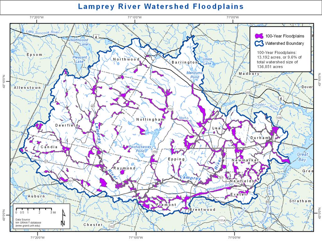
2 Lamprey River Watershed, New Hampshire
3 5 Decades of Population Growth and Development 90,000 18,000 Population 80,000 70,000 60,000 50,000 40,000 30,000 Population (all towns with at least a portion of their area in the watershed) Urban & Developed Land (Lamprey River Watershed) 16,000 14,000 12,000 10,000 8,000 6,000 Acres of Urban & Developed Land 20, ,000
4
5

6
7

8 4 Inch Precipitation Events by Decade Durham, NH Lawrence, MA


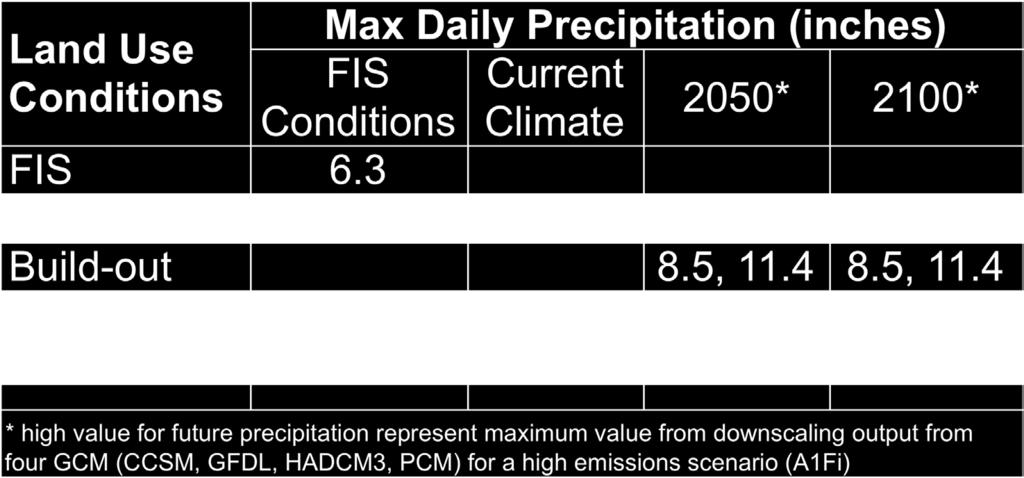
9 100-year Rainfall Estimates TP-40 Rainfall Frequency Atlas used for effective conditions = 6.3 ( ) Northeast Regional Climate Center Atlas for Extreme Precipitation for current conditions = 8.5
10 Daily Discharge, Lamprey River ,000 FIS 100 year flood (7,300 cfs) 4/ / Mothers Day Storm 4/ Patriots Day Nor'easter discharge (cubic feet per second) 6,000 4,000 2,000 3/ Nor'easter Year
11 Costs from Presidentially Declared Disasters in NH
 FEMA 100 yr floodplain")
12 Changing Floodplains with Changing Climate & Land Use Revised 100 yr floodplain with climate change and buildout Revised 100 yr floodplain with buildout Revised 100 yr floodplain with climate change FEMA 100 yr floodplain( 05 conditions) FEMA 100 yr floodplain Stream Channel

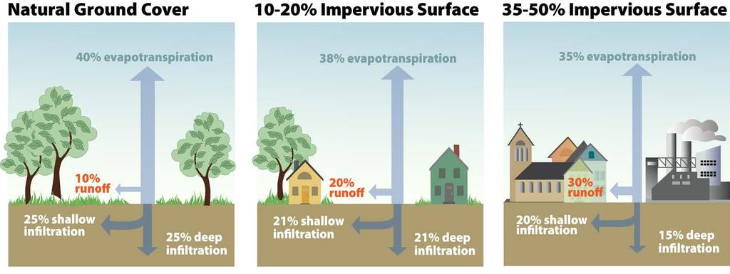
13 Land Use & Climate Scenarios
14 Lamprey River Watershed - Build Out Rates 40,000 30,000 acres 20,000 Residential Development (239 acres per year) 10,000 Commercial and Industrial Development (35 acres per year)

 Conservation lands; public water supply")

15 Starting with total watershed acreage, eliminate: Developed land Mapping Buildout Hydric soils/wetlands/surface water Steep slopes (> 15%, based on soils) Conservation lands; public water supply protection areas Build out flat terrains first, moving incrementally to steeper slopes Within a slope category, build out areas closest to roads first
16
17
18
 Hydrologic Modeling: HEC-GeoHMS & HEC-HMS Hydraulic Modeling: HED-GeoRAS &")
19 Hydrologic Methodology FIS: Annual peak flow frequency analysis peak annual stream flow standard deviation weighted coefficient of skewness Lamprey River Project: Rainfall-Runoff Model Watershed area Time of concentration Runoff curve number (CN) Hydrologic Modeling: HEC-GeoHMS & HEC-HMS Hydraulic Modeling: HED-GeoRAS & HEC-RAS 19

20 Curve Number: Rainfall Runoff Equation

21 Curve Number based on Land Use and Soil Type Subbasin CN W W W W W W W W W W W W6510 W6730 W7060 W7920 W8600 W8380 W11020 W8590 W11900 W10910 W

22 Hydraulic Calibration Results for RT108 Durham Boat House
23 UNH Hydraulics Model Calibration & Results RT River = Beaudette Brook Reach = DS RT108 FP April 2007: modeled=34.4 observed = 34.1 March 2010: modeled =33.6 observed = 33.3 Elevation (ft) Current 100 yr flood = 35.8 FIS 100 yr flood = % increase in the 100-year flood flow from USGS gage: 7,300 cfs (FIS) to 10,649 cfs (NRCC) An increase in the base flood elevations by an average of feet along the 36 mile study reach. Station (ft)
24 Implementing LID 24

 LID build increases flood")
25 Watershed Scale CN and Runoff Conventional build-out increases flood flow by 4.3% (0.3 BFE) LID build increases flood flow by 2.8% increase


26 Urban Scale CN, Runoff, and Discharge


27 Current Conditions CN=66.8 Moonlight Brook, Newmarket LID Build-Out CN=69.5 Forested Type C soil CN = 70 Forested Type D soil CN = 77 Conventional Build-Out CN=78.0 Comm./Ind. Type D soil CN = 80 Residential Type D soil CN = 80 Residential Type D soil CN = 84 Comm./Ind. Type D soil CN = 94
28 New Flood Plain Maps and Questions of Legal Authority, Measures and Consequences In Collaboration with Vermont Law School 1.What is the potential liability of government if they fail to reduce vulnerability to flood risk based on UNH s information? 2.What legal and policy approaches may communities adopt to reduce flood risks in the expanded flood hazard area? 3.Do NH communities have the legal authority under state legislation to design and implement regulatory controls based on current and projected flooding levels? 4.What legal standard of scientific and technical reliability must be met to support regulatory measures based on current and future environmental conditions? 5.What is the potential regulatory takings exposure of communities if they impose regulatory controls that are designed to address anticipated future environmental conditions?

29 FEMA and Current Conditions Lower Lamprey 1 June 2012 Lamprey River Watershed cameron.wake@unh.edu

30 Newmarket Effective 100 Year Floodplain
31 Assessing Flood Risk - Lamprey River Watershed Advisory Committee municipal, regional, state, federal and non-profit representation Cliff Sinnott, Rockingham Planning Commission (Chair) Joanne Cassulo, NH Office of Energy and Planning David Cedarholm, Durham Public Works Cynthia Copeland, Strafford Regional Planning Commission Michael Goetz, FEMA Region 1 Diane Hardy, Newmarket Planning Department Sharon Meeker, Lamprey River Advisory Committee Jack Munn, Southern New Hampshire Planning Commission Jennifer Perry, Exeter Public Works Ron Poltak & Becky Weidman, NEIWPC Keith Robinson, USGS Carl Spang/Dawn Genes, Lamprey River Watershed Association Eric Williams, NH Department of Environmental Services
32 Assessing Flood Risk - Lamprey River Watershed Technical Analysis Construct hydrologic and hydraulic model Develop land use and climate change scenarios Run model; plot cross-sections; map results Dissemination Advisory Group & Focus Groups Community Workshops Municipal & Regional Planners NH GRANIT website Evaluation and Feedback
33
34 Assessing Flood Risk - Lamprey River Watershed Project Objectives: Assess flood risk associated with combined land use and climate change scenarios out to 2100 Produce maps of the 100-year flood risk boundaries and river discharge at specific locations Demonstrate the use of our products to support land use decision-making in coastal communities Serve as a model for other New England watersheds Address legal issues of using projected flood information
35 Projecting Future Climate Change for the Northeast: Greenhouse Gas Emission Scenarios


36 Projecting Future Climate Change for the Northeast: Downscale Global Projections to Regional Level
37
Assessing the Risk of 100-year Freshwater Floods in the Lamprey River Watershed of New Hampshire Resulting from Changes in Climate and Land Use
 Assessing the Risk of 100-year Freshwater Floods in the Lamprey River Watershed of New Hampshire Resulting from Changes in Climate and Land Use Cameron Wake, Institute for the Study of Earth, Oceans and
Assessing the Risk of 100-year Freshwater Floods in the Lamprey River Watershed of New Hampshire Resulting from Changes in Climate and Land Use
 Assessing the Risk of 100-year Freshwater Floods in the Lamprey River Watershed of New Hampshire Resulting from Changes in Climate and Land Use Third Annual Lamprey River Symposium 8 Jan 2010 UNH MUB Newmarket,
Climate and Land Use Consequences to 100-Year Flooding
 Climate and Land Use Consequences to 100-Year Flooding Presented by: Ann Scholz, PE, CPSWQ Grad Student, University of New Hampshire Robert Roseen & Thomas Ballestero, UNH Stormwater Center Michael Simpson,
Assessing the Risk of 100-year Freshwater Floods in the Lamprey River Watershed of New Hampshire Resulting from Changes in Climate and Land Use
 Assessing the Risk of 100-year Freshwater Floods in the Lamprey River Watershed of New Hampshire Resulting from Changes in Climate and Land Use Presented by: Ann Scholz, PE, CPSWQ Advisor: Dr. Robert Roseen,
Climate and Land Use Consequences to 100-Year Flooding
 Climate and Land Use Consequences to 100-Year Flooding Robert Roseen D.WRE, PE, PhD, Ann Scholz, PE, CPSWQ, Thomas Ballestero, PhD, PE, PH, UNH Stormwater Center Nebraska Post- Construction Stormwater
Climate and Land Use Consequences to 100-Year Flooding
 Climate and Land Use Consequences to 100-Year Flooding Robert Roseen D.WRE, PE, PhD, Ann Scholz, PE, CPSWQ, Thomas Ballestero, PhD, PE, PH, UNH Stormwater Center Nebraska Post- Construction Stormwater
Assessing the Risk of 100-year Freshwater Floods in the Lamprey River Watershed of New Hampshire Resulting from Changes in Climate and Land Use
 University of New Hampshire University of New Hampshire Scholars' Repository PREP Reports & Publications Institute for the Study of Earth, Oceans, and Space (EOS) 1-1-2013 Assessing the Risk of 100-year
Growing Your Green Infrastructure Program
 Right Practice, Right Place: Green Infrastructure Technologies that Work in New England Robert Roseen, PhD, D.WRE, PE rroseen@geosyntec.com 617-992-9067 Growing Your Green Infrastructure Program University
Building Resilience to Flooding and Climate Change in the Moonlight Brook Watershed
 Building Resilience to Flooding and Climate Change in the Moonlight Brook Watershed Robert Roseen, Jake Sahl, Waterstone Engineering Nigel Pickering, Rich Claytor, Horsley Witten Group DOWNPOURS AND DROUGHT,
Climate Change and Sea Level Rise in Coastal New Hampshire. Cameron Wake, Ph.D.
 Climate Change and Sea Level Rise in Coastal New Hampshire Cameron Wake, Ph.D. Research Associate Professor Climatology and Glaciology University of New Hampshire Environmental Business Council of New
Hydrologic Calibration:
 Hydrologic Calibration: UPDATE OF EFFECTIVE HYDROLOGY FOR MARYS CREEK October 2010 Agenda Background Hydrologic model Calibrated rainfall Hydrologic calibration 100 year discharges, Existing Conditions
5/25/2017. Overview. Flood Risk Study Components HYDROLOGIC MODEL (HEC-HMS) CALIBRATION FOR FLOOD RISK STUDIES. Hydraulics. Outcome or Impacts
 CALIBRATION FOR FLOOD RISK STUDIES. Hydraulics. Outcome or Impacts") HYDROLOGIC MODEL (HEC-HMS) CALIBRATION FOR FLOOD RISK STUDIES C. Landon Erickson, P.E.,CFM Water Resources Engineer USACE, Fort Worth District April 27 th, 2017 US Army Corps of Engineers Overview Flood
HYDROLOGIC MODEL (HEC-HMS) CALIBRATION FOR FLOOD RISK STUDIES C. Landon Erickson, P.E.,CFM Water Resources Engineer USACE, Fort Worth District April 27 th, 2017 US Army Corps of Engineers Overview Flood
Surprise in Plymouth as flood floods floodplain in flooding season, 28 Feb 2017 (taken from Twitter)
") Surprise in Plymouth as flood floods floodplain in flooding season, 28 Feb 2017 (taken from Twitter) Projecting Future Changes in Flooding Across New England: More Challenging than You Might Think Cameron
Surprise in Plymouth as flood floods floodplain in flooding season, 28 Feb 2017 (taken from Twitter) Projecting Future Changes in Flooding Across New England: More Challenging than You Might Think Cameron
Integrating HEC HMS generated flow hydrographs with FLO-2D. Nanda Meduri, PE, PMP, CFM Seth Lawler Venkata Dinakar Nimmala, CFM
 Integrating HEC HMS generated flow hydrographs with FLO-2D Nanda Meduri, PE, PMP, CFM Seth Lawler Venkata Dinakar Nimmala, CFM Focus of this Presentation Introduction Methodology Challenges & Solutions
IMPROVED MODELING OF THE GREAT PEE DEE RIVER: DOCUMENTATION IN SUPPORT OF FEMA APPEAL. Horry County, South Carolina
 IMPROVED MODELING OF THE GREAT PEE DEE RIVER: DOCUMENTATION IN SUPPORT OF FEMA APPEAL Horry County, South Carolina July 15, 2016 CONTENTS 1 Introduction... 2 2 Hydrology... 3 3 HEC-RAS Model... 7 3.1 Cross
N.H. Sea Grant Research Project Progress Report For time period 2/1/15 1/31/16
 N.H. Sea Grant Research Project Progress Report For time period 2/1/15 1/31/16 Today s date: 30 March 2016 Project number: R/RCE-1 Project title: Analysis and communications of flood damage cost avoidance
INFLOW DESIGN FLOOD CONTROL SYSTEM PLAN PLANT GASTON GYPSUM POND ALABAMA POWER COMPANY
 INFLOW DESIGN FLOOD CONTROL SYSTEM PLAN PLANT GASTON GYPSUM POND ALABAMA POWER COMPANY Section 257.82 of EPA s regulations requires the owner or operator of an existing or new CCR surface impoundment or
SECTION IV WATERSHED TECHNICAL ANALYSIS
 A. Watershed Modeling SECTION IV WATERSHED TECHNICAL ANALYSIS An initial step in the preparation of this stormwater management plan was the selection of a stormwater simulation model to be utilized. It
INFLOW DESIGN FLOOD CONTROL SYSTEM PLAN PLANT BARRY ASH POND ALABAMA POWER COMPANY
 INFLOW DESIGN FLOOD CONTROL SYSTEM PLAN PLANT BARRY ASH POND ALABAMA POWER COMPANY Section 257.82 of EPA s regulations requires the owner or operator of an existing or new CCR surface impoundment or any
INFLOW DESIGN FLOOD CONTROL SYSTEM PLAN 40 C.F.R. PART PLANT YATES ASH POND 3 (AP-3) GEORGIA POWER COMPANY
 GEORGIA POWER COMPANY") INFLOW DESIGN FLOOD CONTROL SYSTEM PLAN 40 C.F.R. PART 257.82 PLANT YATES ASH POND 3 (AP-3) GEORGIA POWER COMPANY EPA s Disposal of Coal Combustion Residuals from Electric Utilities Final Rule (40 C.F.R.
INFLOW DESIGN FLOOD CONTROL SYSTEM PLAN 40 C.F.R. PART 257.82 PLANT YATES ASH POND 3 (AP-3) GEORGIA POWER COMPANY EPA s Disposal of Coal Combustion Residuals from Electric Utilities Final Rule (40 C.F.R.
Green Infrastructure. Jesse Schomberg University of Minnesota Sea Grant Program
 Green Infrastructure Jesse Schomberg University of Minnesota Sea Grant Program Forest Cover Storage (Wetlands) What alters this process? Altered runoff patterns North Shore Streams: Miles of Stream
A Hydrologic Study of the. Ryerson Creek Watershed
 A Hydrologic Study of the Ryerson Creek Watershed Dave Fongers Hydrologic Studies Unit Land and Water Management Division Michigan Department of Environmental Quality May 8, 2002 Table of Contents Summary...2
INFLOW DESIGN FLOOD CONTROL SYSTEM PLAN 40 C.F.R. PART PLANT YATES ASH POND B (AP-B ) GEORGIA POWER COMPANY
 GEORGIA POWER COMPANY") INFLOW DESIGN FLOOD CONTROL SYSTEM PLAN 40 C.F.R. PART 257.82 PLANT YATES ASH POND B (AP-B ) GEORGIA POWER COMPANY EPA s Disposal of Coal Combustion Residuals from Electric Utilities Final Rule (40 C.F.R.
INFLOW DESIGN FLOOD CONTROL SYSTEM PLAN 40 C.F.R. PART 257.82 PLANT YATES ASH POND B (AP-B ) GEORGIA POWER COMPANY EPA s Disposal of Coal Combustion Residuals from Electric Utilities Final Rule (40 C.F.R.
Planning for New Hampshire's Changing Climate: Economic Development for a Sustainable Future. Blending Climate Change Solutions with.
 Planning for New Hampshire's Changing Climate: Blending Climate Change Solutions with Economic Development for a Sustainable Future Cameron Wake Carbon Solutions New England Institute for the Study of
Integrated Watershed Modeling of the Alewife Brook: Developing the Right Tools for Climate Change Preparedness
 Integrated Watershed Modeling of the Alewife Brook: Developing the Right Tools for Climate Change Preparedness David Bedoya, PhD, PE Yovanni Cataño-Lopera, PhD, PE Nicholas Stepina, PE Date Presentation
Climate Research Projects Brief. Steve Miller NH Coastal Adaptation Workgroup GBNERR Coastal Training Program
 Climate Research Projects Brief Steve Miller NH Coastal Adaptation Workgroup GBNERR Coastal Training Program 1. Assessing the Risk of 100-year Freshwater Floods in the Lamprey River Watershed of New Hampshire
SECTION III: WATERSHED TECHNICAL ANALYSIS
 Trout Creek Watershed Stormwater Management Plan SECTION III: WATERSHED TECHNICAL ANALYSIS A. Watershed Modeling An initial step this study of the Trout Creek watershed was the selection of a stormwater
Sunapee Watershed Stormwater Infrastructure Project. A Study of the Lake Sunapee Watershed. NOAA funded, 2-year grant
 Sunapee Watershed Stormwater Infrastructure Project A Study of the Lake Sunapee Watershed NOAA funded, 2-year grant Research Team Latham Stack, Syntectic, LLC Michael Simpson, Antioch University New England
Climate Change in Southern NH
 Climate Change in Southern NH Cameron Wake Institute for the Study of Earth, Oceans, & Space Josephine A. Lamprey Professor, Climate & Sustainability University of New Hampshire @TheClimateDr Resilient
Impervious Surface Analysis for Durham Under Current and Build-Out Conditions In Support of Stormwater Management
 University of New Hampshire University of New Hampshire Scholars' Repository PREP Publications Institute for the Study of Earth, Oceans, and Space (EOS) 10-22-2007 Impervious Surface Analysis for Durham
Climate Change Implications for Stormwater Management in Massachusetts. Thomas Maguire, MassDEP March 2014
 Climate Change Implications for Stormwater Management in Massachusetts Thomas Maguire, MassDEP March 2014 Temperature ( o F) Boston, MA: Temperature Average Annual 1873 to 2013 R² = 0.4 54 2012 2010 52
Recent Activities of the Maryland Hydrology Panel
 Recent Activities of the Maryland Hydrology Panel Kaye L. Brubaker, University of Maryland, College Park Wilbert O. Thomas, Jr., Michael Baker International MAFSM 12 th Annual Conference Linthicum, Maryland
INITIAL INFLOW DESIGN FLOOD CONTROL SYSTEM PLAN PLANT MCMANUS ASH POND A (AP-1) 40 CFR
 40 CFR") INITIAL INFLOW DESIGN FLOOD CONTROL SYSTEM PLAN PLANT MCMANUS ASH POND A (AP-1) 40 CFR 257.82 EPA s Disposal of Coal Combustion Residuals from Electric Utilities Final Rule (40 C.F.R. Part 257 and Part
INITIAL INFLOW DESIGN FLOOD CONTROL SYSTEM PLAN PLANT MCMANUS ASH POND A (AP-1) 40 CFR 257.82 EPA s Disposal of Coal Combustion Residuals from Electric Utilities Final Rule (40 C.F.R. Part 257 and Part
Rainfall, Runoff and Peak Flows: Calibration of Hydrologic Design Methods for the Kansas City Area
 Rainfall, Runoff and Peak Flows: Calibration of Hydrologic Design Methods for the Kansas City Area Bruce McEnroe, Bryan Young, Ricardo Gamarra and Ryan Pohl Department of Civil, Environmental, and Architectural
Hydrologic Study Report for Single Lot Detention Basin Analysis
 Hydrologic Study Report for Single Lot Detention Basin Analysis Prepared for: City of Vista, California August 18, 2006 Tory R. Walker, R.C.E. 45005 President W.O. 116-01 01/23/2007 Table of Contents Page
PWD s Systematic Watershed-wide Approach to Stormwater Mgmt.
 PWD s Systematic Watershed-wide Approach to Stormwater Mgmt. Jeffrey Featherstone, PhD Director, Center for Sustainable Communities, Temple University Paul DeBarry, PE, PH, GISP, D.WRE Director, Geospatial
SEWRPC Staff Memorandum
 SEWRPC Staff Memorandum EVALUATION OF PROPOSED STORMWATER QUANTITY MANAGEMENT FOR THE DES PLAINES RIVER WATERSHED PORTION OF THE PROPOSED FOXCONN DEVELOPMENT IN THE VILLAGE OF MOUNT PLEASANT June, 2018
PTAPP Meeting May 19, 2015 DRAFT PRELIMINARY MODEL RESULTS, NOT FOR DISTRIBUTION
 PTAPP Meeting May 19, 2015 WISE PROJECT TEAM Robert Roseen, Project Lead Renee Bourdeau, Project Manager Chad Yaindl, Senior Staff Engineer Alison Watts, Watershed Science Lead Cliff Sinnott and Theresa
Appendix A Watershed Modeling Technical Data
 Appendix A Watershed Modeling Technical Data An overview of the process that was used to complete the hydrologic modeling in preparation of this Plan is presented in Section 6 Technical Analysis of this
INFLOW DESIGN FLOOD CONTROL SYSTEM PLAN 40 C.F.R. Part PLANT MCINTOSH ASH POND 1 GEORGIA POWER COMPANY
 INFLOW DESIGN FLOOD CONTROL SYSTEM PLAN 40 C.F.R. Part 257.82 PLANT MCINTOSH ASH POND 1 GEORGIA POWER COMPANY EPA s Disposal of Coal Combustion Residuals from Electric Utilities Final Rule (40 C.F.R. Part
INFLOW DESIGN FLOOD CONTROL SYSTEM PLAN 40 C.F.R. PART PLANT DANIEL ASH POND B MISSISSIPPI POWER COMPANY
 INFLOW DESIGN FLOOD CONTROL SYSTEM PLAN 40 C.F.R. PART 257.82 PLANT DANIEL ASH POND B MISSISSIPPI POWER COMPANY EPA s Disposal of Coal Combustion Residuals from Electric Utilities Final Rule (40 C.F.R.
INFLOW DESIGN FLOOD CONTROL SYSTEM PLAN PLANT GREENE COUNTY ASH POND ALABMA POWER COMPANY
 INFLOW DESIGN FLOOD CONTROL SYSTEM PLAN PLANT GREENE COUNTY ASH POND ALABMA POWER COMPANY Section 257.82 of EPA s regulations requires the owner or operator of an existing or new CCR surface impoundment
INFLOW DESIGN FLOOD CONTROL SYSTEM PLAN 40 C.F.R. PART PLANT BOWEN ASH POND 1 (AP-1) GEORGIA POWER COMPANY
 GEORGIA POWER COMPANY") INFLOW DESIGN FLOOD CONTROL SYSTEM PLAN 40 C.F.R. PART 257.82 PLANT BOWEN ASH POND 1 (AP-1) GEORGIA POWER COMPANY EPA s Disposal of Coal Combustion Residuals from Electric Utilities Final Rule (40 C.F.R.
INFLOW DESIGN FLOOD CONTROL SYSTEM PLAN 40 C.F.R. PART 257.82 PLANT BOWEN ASH POND 1 (AP-1) GEORGIA POWER COMPANY EPA s Disposal of Coal Combustion Residuals from Electric Utilities Final Rule (40 C.F.R.
Urban Watershed Renewal in Berry Brook: An Examination of Impervious Cover, Stream Restoration and Ecosystem Response
 Urban Watershed Renewal in Berry Brook: An Examination of Impervious Cover, Stream Restoration and Ecosystem Response Robert Roseen, Tom Ballestero, Melinda Bubier, Joel Ballestero, James Houle, Dean Peschel,
Robert Wood, Associate Director & Watershed Steward Lake Sunapee Protective Association (LSPA)
") Robert Wood, Associate Director & Watershed Steward Lake Sunapee Protective Association (LSPA) LSPA Non-profit, 100+ yrs Environmental Education: public schools, community programs, general public Water
Robert Wood, Associate Director & Watershed Steward Lake Sunapee Protective Association (LSPA) LSPA Non-profit, 100+ yrs Environmental Education: public schools, community programs, general public Water
MIDAS CREEK PROJECT. FINAL DESIGN REPORT SKR Hydrotech 4/11/2012
 2012 MIDAS CREEK PROJECT FINAL DESIGN REPORT SKR Hydrotech 4/11/2012 Executive Summary... 1 Section 1 Introduction... 1 Background Information... 1 Purpose of Study... 1 Scope of Work... 1 Section 2 Description
ACKNOWLEDGEMENTS. Sincerely, Executive Director and Staff. Rockingham Planning Commission. 156 Water Street Exeter, NH (603)
") ACKNOWLEDGEMENTS The gratefully acknowledges the participation of coastal New Hampshire municipalities in the preparation of this report: City of Portsmouth Town of New Castle Town of Rye Town of North
ACKNOWLEDGEMENTS The gratefully acknowledges the participation of coastal New Hampshire municipalities in the preparation of this report: City of Portsmouth Town of New Castle Town of Rye Town of North
Engineering Report Preliminary Floodplain Study. Executive Summary
 Executive Summary Engineering Report Preliminary Floodplain Study The Federal Emergency Management Agency (FEMA) has updated the Flood Insurance Rate Maps (FIRM) for Finney County, including the City of
NEW HAMPSHIRE COASTAL RISK AND HAZARDS COMMISSION. Preparing New Hampshire for Projected Storm Surge, Sea-Level Rise, and Extreme Precipitation
 NEW HAMPSHIRE COASTAL RISK AND HAZARDS COMMISSION Preparing New Hampshire for Projected Storm Surge, Sea-Level Rise, and Extreme Precipitation Final Report and Recommendations November 2016 The final report
Chapter 6. Hydrology. 6.0 Introduction. 6.1 Design Rainfall
 6.0 Introduction This chapter summarizes methodology for determining rainfall and runoff information for the design of stormwater management facilities in the City. The methodology is based on the procedures
HYDROLOGIC MODELING CONSISTENCY AND SENSITIVITY TO WATERSHED SIZE
 HYDROLOGIC MODELING CONSISTENCY AND SENSITIVITY TO WATERSHED SIZE by James C.Y. Guo. Professor, Civil Engineering, U. Of Colorado at Denver, James.Guo@cudenver.edu.. And Eric Hsu, Project Engineer, Parson
The Cost of Green Infrastructure: Worth the Investment?
 University of Southern Maine USM Digital Commons Green Infrastructure New England Environmental Finance Center (NEEFC) 11-2013 The Cost of Green Infrastructure: Worth the Investment? Martha Sheils New
COUNTY OF KANE. Kishwaukee River Headwaters Study Stakeholder Meeting Monday, February 26, :30 am Hampshire Village Hall
 COUNTY OF KANE ENVIRONMENTAL AND BUILDING MANAGEMENT Timothy Harbaugh, P.E., DEE Director County Government Center 719 Batavia Avenue Geneva, IL 60134 www.co.kane.il.us Environmental Management: (630)
INITIAL RUN-ON AND RUN-OFF CONTROL PLAN 40 C.F.R. PART 257
 INITIAL RUN-ON AND RUN-OFF CONTROL PLAN 40 C.F.R. PART 257.81 HUFFAKER ROAD (PLANT HAMMOND) PRIVATE INDUSTRIAL LANDFILL (HUFFAKER ROAD LANDFILL) GEORGIA POWER COMPANY EPA s Disposal of Coal Combustion
2016 New Hampshire Water & Watershed Conference Plymouth State University Friday, March 18, 2016
 Robert Roseen rroseen@waterstone-eng.com Waterstone Engineering Nigel Pickering npickering@horsleywitten.com Horsley Witten Group 2016 New Hampshire Water & Watershed Conference Plymouth State University
Beaver Brook Flood Study
 Alternatives Analysis Beaver Brook Flood Study Pelham, New Hampshire PREPARED FOR Town of Pelham 6 Village Green Pelham, NH 03076 PREPARED BY 101 Walnut Street PO Box 9151 Watertown, MA 02471 617.924.1770
BMP Design Aids. w w w. t r a n s p o r t a t i o n. o h i o. g o v. Equations / Programs
 BMP Design Aids 1 Equations / Programs Outlet Discharge Equations Hydrograph and Pond Routing Programs USGS StreamStats 2 Ohio Department of Transportation 1 Training Intent Introduction and overview of
Estimating the 100-year Peak Flow for Ungagged Middle Creek Watershed in Northern California, USA
 American Journal of Water Resources, 2014, Vol. 2, No. 4, 99-105 Available online at http://pubs.sciepub.com/ajwr/2/4/3 Science and Education Publishing DOI:10.12691/ajwr-2-4-3 Estimating the 100-year
Office of Strategic Planning and Projects Connecticut Department of Transportation CLIMATE CHANGE & EXTREME WEATHER PILOT PROJECT
 Office of Strategic Planning and Projects Connecticut Department of Transportation CLIMATE CHANGE & EXTREME WEATHER PILOT PROJECT LITCHFIELD HILLS Lake Waramaug, Warren/Kent/Washington LITCHFIELD HILLS
GISHYDRO: Developing Discharges and Watershed Parameters
 GISHYDRO: Developing Discharges and Watershed Parameters A Case Study with Baltimore City Watersheds by Mathini Sreetharan, Ph.D., P.E., CFM, Dewberry, VA Kim Dunn, P.E., CFM, Dewberry, PA Baltimore City
Who s in Charge!? 8/9/2018. Houston Geological Society Presents. Peak Floods Brays Bayou
 Houston Geological Society Presents An Informational Workshop Flooding and Floodplains in the Houston Area: Past, Present, and Future: Part 1 Presented May 18, 2018 Dr. William R. Dupre Professor Emeritus
Reservoir on the Rio Boba
 Reservoir on the Rio Boba Michael J. Burns II Guillermo Bustamante J. James Peterson Executive Summary The National Institute of Water Resources in the Dominican Republic (INDRHI) plans to construct a
Margaret Walls. RFF First Wednesday Seminar. Green Infrastructure: Using Natural Landscapes for Flood Mitigation and Water Quality Improvements
 THE ROLE OF LAND USE IN ADAPTATION TO INCREASED PRECIPITATION AND FLOODING Margaret Walls RFF First Wednesday Seminar Green Infrastructure: Using Natural Landscapes for Flood Mitigation and Water Quality
APPENDIX IV. APPROVED METHODS FOR QUANTIFYING HYDROLOGIC CONDITIONS OF CONCERN (NORTH ORANGE COUNTY)
") APPENDIX IV. APPROVED METHODS FOR QUANTIFYING HYDROLOGIC CONDITIONS OF CONCERN (NORTH ORANGE COUNTY) Hydromodification design criteria for the North Orange County permit area are based on the 2- yr, 24-hr
APPENDIX IV. APPROVED METHODS FOR QUANTIFYING HYDROLOGIC CONDITIONS OF CONCERN (NORTH ORANGE COUNTY) Hydromodification design criteria for the North Orange County permit area are based on the 2- yr, 24-hr
Flood Control Planning Below Alluvial Fans
 Flood Control Planning Below Alluvial Fans Presenter: Contributors: Aric Torreyson P.E., Program Manager, Tetra Tech Inc. Nathan Schreiner, P.E., Project Manager, Tetra Tech Inc. Tesfaye Demissie, P.E.,
CEDAR RUN WATERSHED ACT 167 STORMWATER MANAGEMENT PLAN FINAL REPORT
 CEDAR RUN WATERSHED ACT 167 STORMWATER MANAGEMENT PLAN FINAL REPORT I. PURPOSE OF THE REPORT The purpose of this report is to summarize the findings and recommendations of the Cedar Run Watershed Act 167
Sea Level Rise and Recurrent Flooding Update
 Sea Level Rise and Recurrent Flooding Update Informational Briefing City Council Meeting September 18, 2018 Thomas M. Leahy, Deputy City Manager The Sea, Inland Waters, & Groundwater are Rising Projected
INFLOW DESIGN FLOOD CONTROL SYSTEM PLAN. Bremo Power Station CCR Surface Impoundment: North Ash Pond INFLOW DESIGN FLOOD
 INFLOW DESIGN FLOOD CONTROL SYSTEM PLAN INFLOW DESIGN FLOOD CONTROL SYSTEM PLAN Bremo Power Station CCR Surface Impoundment: North Ash Pond Submitted To: Bremo Power Station 1038 Bremo Bluff Road Bremo
Little Bear Brook Flood Hazard Assessment and Redevelopment Area Regional Stormwater Management Analysis. Progress Meeting
 Little Bear Brook Flood Hazard Assessment and Redevelopment Area Regional Stormwater Management Analysis Progress Meeting June 30, 2014 Princeton Hydro, LLC and SWM Consulting, LLC Project Team West Windsor
LAKE COUNTY HYDROLOGY DESIGN STANDARDS
 LAKE COUNTY HYDROLOGY DESIGN STANDARDS Lake County Department of Public Works Water Resources Division 255 N. Forbes Street Lakeport, CA 95453 (707)263-2341 Adopted June 22, 1999 These Standards provide
TABLE OF CONTENTS. 1.0 Background Watershed Description Hydrology - HEC-HMS Models Hydraulics - HEC-RAS Models...
 TABLE OF CONTENTS 1.0 Background... 1 2.0 Watershed Description... 1 3.0 Hydrology - HEC-HMS Models... 2 3.1 Hydrologic Approach... 2 3.2 Drainage Areas... 2 3.3 Curve Numbers... 2 3.4 Lag Times... 3 3.5
INITIAL RUN-ON AND RUN-OFF CONTROL PLAN 40 C.F.R. PART 257
 INITIAL RUN-ON AND RUN-OFF CONTROL PLAN 40 C.F.R. PART 257.81 PLANT BOWEN PRIVATE INDUSTRY SOLID WASTE DISPOSAL FACILITY (ASH LANDFILL) GEORGIA POWER COMPANY EPA s Disposal of Coal Combustion Residuals
Building Partnerships for Climate and Health Programs FINAL REPORT
 Building Partnerships for Climate and Health Programs FINAL REPORT 8/30/12 Prepared for: The Association of State and Territorial Health Officials 2231 Crystal Drive Arlington, VA 22202 Prepared By: New
I(n)Kn. A Qp = (PRF) --- (8) tp Where A is the watershed area in square miles and PRF is the unit hydrograph peak rate factor.
Kn. A Qp = (PRF) --- (8) tp Where A is the watershed area in square miles and PRF is the unit hydrograph peak rate factor.") AN ALTERNATE APPROACH FOR ESTIMATING SCS UNIT HYDROGRAPH PEAK RATE FACTORS (PRFS) IN SOUTHWEST FLORIDA Himat Solanki Southwest Florida Water Management District 115 Corporation Way, Venice, Florida 34292
AN ALTERNATE APPROACH FOR ESTIMATING SCS UNIT HYDROGRAPH PEAK RATE FACTORS (PRFS) IN SOUTHWEST FLORIDA Himat Solanki Southwest Florida Water Management District 115 Corporation Way, Venice, Florida 34292
Project Summary: - Hydrologic Models. - LiDAR Based - 10 Synthetic Events - No Historic Events - 100yr Runoff is Largest - Assumes Even Rainfall
 Project Summary: - Hydrologic Models Phase 2 Underway Nearly Completed (Park/Pembina EOY) - LiDAR Based - 10 Synthetic Events - No Historic Events - 100yr Runoff is Largest - Assumes Even Rainfall Phase
Prepared for: City of Jeffersonville. November Prepared by
 JEFFERSONVILLE STORMWATER MASTER PLAN HYDRAULICS APPENDIX JEFFERSONVILLE, INDIANA Prepared for: City of Jeffersonville November 2011 Prepared by Christopher B. Burke Engineering, Ltd. 115 W. Washington
City of Katy Flood Protection Study (Meeting 3 of 3) October 23, 2017
 October 23, 2017") City of Katy Flood Protection Study (Meeting 3 of 3) October 23, 2017 Phasing of Meetings April Meeting May Meeting October Review of Tax Day Storm Event and Immediate Actions Taken By City Review of Coordination
City of Katy Flood Protection Study (Meeting 3 of 3) October 23, 2017 Phasing of Meetings April Meeting May Meeting October Review of Tax Day Storm Event and Immediate Actions Taken By City Review of Coordination
FAST WATER / SLOW WATER AN EVALUATION OF ESTIMATING TIME FOR STORMWATER RUNOFF
 FAST WATER / SLOW WATER AN EVALUATION OF ESTIMATING TIME FOR STORMWATER RUNOFF Factors Affecting Stormwater Runoff: Rainfall intensity % Impervious surfaces Watershed size Slope Soil type, soil compaction
RUN-ON AND RUN-OFF CONTROL PLAN 40 C.F.R. PART PLANT DANIEL NORTH ASH MANAGEMENT UNIT MISSISSIPPI POWER COMPANY
 RUN-ON AND RUN-OFF CONTROL PLAN 40 C.F.R. PART 257.81 PLANT DANIEL NORTH ASH MANAGEMENT UNIT MISSISSIPPI POWER COMPANY EPA s Disposal of Coal Combustion Residuals from Electric Utilities Final Rule (40
Hydrologic evaluation of flood flows from a burned watershed
 Flood Recovery, Innovation and Response II 257 Hydrologic evaluation of flood flows from a burned watershed A. W. Miller & E. J. Nelson Department of Civil & Environmental Engineering, Brigham Young University,
Vulnerability of Infrastructure due to Climate Change
 1 Vulnerability of Infrastructure due to Climate Change A Case Study of London, Ontario Elisabeth Bowering and Angela Peck M. E. Sc. Candidates Slobodan P. Simonovic, Professor The University of Western
Case Studies in Hazard Class Reductions Implementation of NY s Guidance for Dam Hazard Classification
 Case Studies in Hazard Class Reductions Implementation of NY s Guidance for Dam Hazard Classification Gregory J Daviero, PhD, PE, Principal Kevin Ruswick, PE, CFM, Associate May 2, 2014 Schnabel Engineering
HEC-17: Highways in the River Environment Flood Plains, Extreme Events, Risk, and Resilience
 HEC-17: Highways in the River Environment Flood Plains, Extreme Events, Risk, and Resilience Roger Kilgore, P.E., D.WRE, Kilgore Consulting and Management George Herrmann, Ph.D., P.E., D. WRE, Desert Sky
LIST OF TABLES.II LIST OF FIGURES.II LIST OF ATTACHMENTS.II I. INTRODUCTION.1 II. STUDY AREA.3 III
 Table of Contents LIST OF TABLES...II LIST OF FIGURES...II LIST OF ATTACHMENTS...II I. INTRODUCTION...1 II. STUDY AREA...3 III. PRECIPITATION-RUNOFF PROCESSES AND FLOW ROUTING SIMULATION WITH HEC-HMS 4
Climate Change Resilience and the Vermont Agency of Transportation
 Climate Change Resilience and the Vermont Agency of Transportation Gina Campoli, Environmental Policy Manager Vermont Agency of Transportation Flooding, Vulnerability and Risk Oh My! AASHTO s 21 st Century
Technical Memorandum
 Tucson Office 3031 West Ina Road Tucson, AZ 85741 Tel 520.297.7723 Fax 520.297.7724 www.tetratech.com Technical Memorandum To: Kathy Arnold From: Greg Hemmen, P.E. Company: Rosemont Copper Company Date:
DRAFT FOREST VIEW, ILLINOIS SECTION 205 FLOOD RISK MANAGEMENT APPENDIX E HYDROLOGY AND HYDRAULIC ANALYSIS
 FOREST VIEW, ILLINOIS SECTION 205 FLOOD RISK MANAGEMENT APPENDIX E HYDROLOGY AND HYDRAULIC ANALYSIS U.S. Army Corps of Engineers, Chicago District Hydraulics and Environmental Engineering Section 17 March
Sea-Level Rise Impacts on Drinking Water: A Groundwater Modeling Study in Newmarket, NH
 Sea-Level Rise Impacts on Drinking Water: A Groundwater Modeling Study in Newmarket, NH Jennifer Jacobs 1, Jayne Knott 1, Elizabeth Durfee 2, Rachael Mack 2, and Kyle Pimental 2, University of New Hampshire
DRAFT. Jacob Torres, P.E.; Nick Fang, Ph.D., P.E.
 \ Memorandum SSPEED Center at Rice University Department of Civil & Environmental Engineering 6100 Main MS-317 Houston, Texas 77005-1827 sspeed.rice.edu tel: 713-348-4977 To Andy Yung, P.E. CFM; Lane Lease,
Are Flood Stages Rising? Our Fault or Mother Nature s?!
 Are Flood Stages Rising? Our Fault or Mother Nature s?! ASFPM National Conference June 4, 2014 Presented by: Siavash Beik, PE, CFM, D.WRE Peggy Shepherd, P.E., CFM Christopher B. Burke Engineering, LLC
Stormwater Review Part 2. Rainfall and Runoff. Tom Seybert, PE and Andy Bennett, PE. Pennsylvania Surveyors Conference 2019
 Stormwater Review Part 2 Rainfall and Runoff Tom Seybert, PE and Andy Bennett, PE Pennsylvania Surveyors Conference 2019 1 Topics Covered 1. Rainfall characteristics and sources 2. Watershed characteristics
Creating a Flood Forecasting System for the San Diego River Watershed
 Creating a Flood Forecasting System for the San Diego River Watershed Rand Allan County of San Diego Flood Control Martin J. Teal, P.E., P.H., D.WRE WEST Consultants inc. OUTLINE San Diego River Watershed
Jacobi, Toombs, and Lanz, Inc.
 Area 5: Blackiston Mill Road at Dead Man's Hollow Flooding Assessment Jacobi, Toombs, and Lanz, Inc. This document summarizes an assessment of drainage and flooding concerns and provides recommendations
The prioritization list along with the estimated probable construction cost and future cost index is shown in Table 1.
 EXECUTIVE SUMMARY To address flooding concerns and assess costs of potential capital improvement projects associated with flooding in the downtown Town Center Area Plan (TCAP), the Town of Cary commissioned
MODULE 1 RUNOFF HYDROGRAPHS WORKSHEET 1. Precipitation
 Watershed MODULE 1 RUNOFF HYDROGRAPHS WORKSHEET 1 A watershed is an area of land thaaptures rainfall and other precipitation and funnels it to a lake or stream or wetland. The area within the watershed
Modeling Infiltration BMPs
 Modeling Infiltration BMPs CAHILL ASSOCIATES Environmental Consultants West Chester, PA (610) 696-4150 www.thcahill.com Design Goals for Calculations 1. Mitigate Peak Rates 2-Year to 100-Year 2. No Volume
SUMMARY OF BACKGROUND INFORMATION REVIEWED
 TO: FROM: Mark Lobermeier, PE Ismael Martinez, PE Brad Woznak, PE, PH, CFM Tim Diedrich, PE DATE: RE: Kinni Corridor Plan - Hydrologic & Hydraulic Analysis Summary SEH No. RIVER 138553 14.00 This draft
Cokato Lake (86-263) Wright County. Hydrologic Investigation
 Wright County. Hydrologic Investigation") Cokato Lake (86-263) Wright County Hydrologic Investigation April 14, 2005 Cokato Lake (86-263) Wright County Hydrologic Investigation April 14, 2005 Problem Statement In recent years, heavy rainfall has
Cokato Lake (86-263) Wright County Hydrologic Investigation April 14, 2005 Cokato Lake (86-263) Wright County Hydrologic Investigation April 14, 2005 Problem Statement In recent years, heavy rainfall has
DRAINAGE PLAN OF NAU S EASTBURN EDUCATION AND GAMMAGE BUILDINGS FINAL PROPOSAL
 MAY 10, 2016 DRAINAGE PLAN OF NAU S EASTBURN EDUCATION AND GAMMAGE BUILDINGS FINAL PROPOSAL Connor Klein, Jiangnan Yi, Yuzhi Zhang, Yi Yang NORTHERN ARIZONA UNIVERSITY NAU Water Buffalo Engineering Table
PA of NY&NJ - TETERBORO AIRPORT RUNWAY 6-24 Engineered Material Arresting System (EMAS) UNSTEADY-STATE FLOODPLAIN ANALYSIS
 UNSTEADY-STATE FLOODPLAIN ANALYSIS") 1 NEW JERSEY ASSOCIATION FOR FLOODPLAIN MANAGEMENT PRESENTATION FOR THE 10 TH ANNUAL CONFERENCE PA of NY&NJ - TETERBORO AIRPORT RUNWAY 6-24 Engineered Material Arresting System (EMAS) UNSTEADY-STATE FLOODPLAIN
1 NEW JERSEY ASSOCIATION FOR FLOODPLAIN MANAGEMENT PRESENTATION FOR THE 10 TH ANNUAL CONFERENCE PA of NY&NJ - TETERBORO AIRPORT RUNWAY 6-24 Engineered Material Arresting System (EMAS) UNSTEADY-STATE FLOODPLAIN