Floodplain & Water Resources Management. Opportunities & Challenges
|
|
|
- Damian Alexander
- 5 years ago
- Views:
Transcription
1 Floodplain & Water Resources Management Opportunities & Challenges ASFPM Annual Conference Grand Rapids, Michigan June 21, 2016 Jim Morris Director USGS Michigan-Ohio Water Science Center
2 USGS provides science about the natural hazards that threaten lives and livelihoods; the water, energy, minerals, and other natural resources we rely on; the health of our ecosystems and environment; and the impacts of climate and land-use change. Our scientists develop new methods and tools to supply timely, relevant, and useful information about the Earth and its processes.
 including a National Center in")
3 Water Workforce Water program staff are located at nearly 180 locations (all 50 States, Puerto Rico, American Samoa and Guam) including a National Center in Reston.
4 That s exactly the state of water we ve got crises percolating all over, but lack the data necessary to make smart policy decisions. Charles Fishman - author of The Big Thirst: The Secret Life and Turbulent Future of Water. ( Water Is Broken. Data Can Fix It. New York Times OpEd March 17, 2016)


5
6 Good data creates useful information Useful information creates informed knowledge Informed knowledge supports effective actions

 4% $6.")
7 Surface Water Streamgage Network More than 8,100 real-time surfacewater discharge sites Funded by over 850 partners Totaling $160M in FY15 Funding Sources USGS Groundwater and Streamflow Information Program (Federal Priority Streamgages) 31% $49.4M Other Federal Agencies 18% $28.5M Other (FERC, Coop R&D Agreements) 4% $6.4M States, municipalities, and Tribes 47% $75.4M


8 Water Data Delivery NWISweb webpages WaterServices streamed data WaterAlert push WaterNow on demand WaterWatch mapping Surface WaterWatch GroundwaterWatch WaterQualityWatch (Temp)

9 WaterWatch

10 WaterAlert: Gages Can Contact You! Site number Contact information Alert level

11 Future of water data delivery Redesigned to provide a nationwide interactive and map-based water data dashboard
12 Open and accessible data USGS has always had as part of its mission to make accessible its data as soon as possible New White House initiatives (2013) are driving all federally funded research to make the data collected and used in the research accessible to the public

13 Real-time Data Delivery Demands 80 NWISWeb and NWIS Water Services in Millions of Successful Page Requests per month Water Services Water Data Through July, 2015


14 USGS and NWS Data Networks Close to 8,100 USGS Gages reporting current stream conditions in NWIS Over 3,400 NWS Flood Forecast/Warning locations in AHPS
15 USGS Streamgaging and NWS Flood Forecasting Partnership NWS Rainfall Forecast Rainfall Runoff Model USGS Rating More than 8,100 USGS Streamgages Over 4,000 NWS River Forecast Locations USGS Observations NWS Predictions


16 Flood Inundation Mapping Program Flood Inundation Maps translate a hydrograph into operational maps that communicate risk and consequences Create a flood map library at a USGS gage Uses hydraulic modeling and GIS Sister program with NWS Allow anyone that meets USGS standards to submit a library (Furnished FIM)
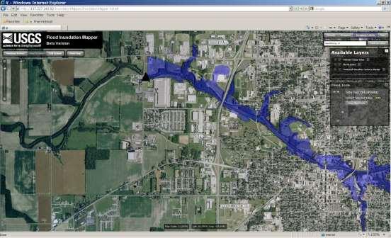
17


18


19 FIM becomes a tool for flood Preparedness What-if scenarios Response Tied to gage & forecast data Recovery Damage assessment Mitigation & planning Flood risk analyses Environmental & ecological assessments


20 FIM becomes a tool for flood Ecological studies of floodplains Such as frequency of inundation Riparian habitat 7-day inundation areas Hazardous substance spills Kalamazoo River Oil Spill
21 USGS Current FIM Research Directions RapidFIM Testing viability and accuracy of non-h&h methods of developing flood map libraries Bathtub; GISFlood Tool; FIS interpolation; Imagery (photo and satellite) processing SAR (synthetic aperture radar) from satellite and UAV was tested in the most recent event on the Missouri/Mississippi. EcoFIM Wetland and/or soils based mapping Working with biologists on additional parameters i.e. x-day inundation areas, velocity mapping, and habitat indexes.
22 USGS Current FIM Research, Cont. SatelliteFIM Partnership with NASA Ames Robotic Lab and EROS to bring their imagery analysis algorithms to HDDS Operationalize the identification of inundation areas in remote observations LANDSAT, MODIS, SAR, Pilot algorithms in place by Q2 FY17 Automatic routines established by Q4FY17
23 Michigan FIM Efforts Lansing completed Presentation today by Cyndi Rachol session B7 at 1:45, room GGO-G Hamberg in progress Under Discussion Newagyo Ann Arbor
24 Integrated Water Resources Science & Services (IWRSS) Goals: integrate information delivery and simplify access to this data increase accuracy and timeliness of water information provide summit-to-the-sea high resolution water resources information and forecasts Currently the collaboration is with four United States (U.S.) federal agencies: USACE, USGS, NOAA-NWS, FEMA
25 ACWI Subcommittee on Hydrology Streamflow Information Collaborative New workgroup comprised of federal, state, and local partners Come together to further the implementation of a national network of streamgages to meet the myriad of streamflow information needs Create cohesive messaging about the value, uses, economic benefits, and critical gaps in our Nation s streamflow information network


26 Streamgaging Forwards and Backwards


27 Streamgaging Forwards Satellite Observed Discharge Accuracy ~67% for 4-day mean discharges Brakenbridge and others, 2012 Journal of Hydrology UAS Non-contact Velocity Continuous Wave Microwave Large Scale Particle Image Velocimetry Non-contact Stage RDG
28 Annual Peak Discharge [cfs] Annual Peak Discharge [cfs] Streamgaging Backwards: B17C But we know big floods occurred in the 1950 s and 1960 s Historical Record peak and 1969 peak New info used by B17C : perception range Systematic Record years Ocheyeden River near Spencer, Iowa
29 B17C Results: Ocheyeden River near Spencer, Iowa Gaged Record Only Annual exceedance probability 1% AEP Flood: 7,912 cfs
30 B17C Results: Ocheyeden River near Spencer, Iowa Gaged Record Only Historical Information Added Annual exceedance probability Annual exceedance probability 1% AEP Flood: 7,912 cfs 17,170 cfs
31 Bulletin 17C Workshop Training Workshop Today at 3:00 Room RO-B Julie Kiang, USGS Officeof Surface Water

32

33
34 Opportunities All collectd flood information can be helpful Bulletin 17C can make use of information collected from old newspapers, pictures, paoleo record, etc. to help inform foll frequency predictions USGS will be adding the opportunity for furnished high water marks to be added to the USGS high water database, creating an opportunity to store, save, and deliver this information
35 Challenges Coordinating data collection and information products Creating long-term support for data collection networks Understanding the uncertainities involved in different data collection efforts Working together and sharing great ideas
36 Good data creates useful information Useful information creates informed knowledge Informed knowledge supports effective actions
37 Thanks
Water Science Update. William Guertal. Deputy Associate Director for Water. ICWP Meeting September 30, 2015
 Water Science Update William Guertal Deputy Associate Director for Water ICWP Meeting September 30, 2015 U.S. Department of the Interior U.S. Geological Survey Water Vision Providing real-time information
USGS Flood Inundation Mapping: Plans for a Collaborative Future
 USGS Flood Inundation Mapping: Plans for a Collaborative Future Marie C. Peppler USGS FIM Program Liaison U.S. Department of the Interior U.S. Geological Survey USGS and NWS Data Networks Over 9,000 USGS
USGS & NWS Flood Inundation Mapping
 USGS & NWS Flood Inundation Mapping Georgia Association of Floodplain Managers March 2011 Brian McCallum USGS GA Water Science Center (w/ assistance from Tom Graziano, NWS) U.S. Department of the Interior
U.S. Geological Survey Streamflow data in Michigan Using the USGS NWIS database MDOT Bridge Scour Conference October 5, 2017
 U.S. Geological Survey Streamflow data in Michigan Using the USGS NWIS database MDOT Bridge Scour Conference October 5, 2017 Tom Weaver Eastern Hydrologic Data Chief Upper Midwest Water Science Center
USGS Streamgage and Indiana Water Quality Optimization
 USGS Streamgage and Indiana Water Quality Optimization An Indiana Silver Jackets and Indiana Water Monitoring Council Assessment Jeff Frey USGS Ohio-Kentucky-Indiana Water Science Center Many Agencies
Transforming NOAA Water Resources Prediction
 Transforming NOAA Water Resources Prediction Presented to APA Water and Planning Connect Conference September 12, 2018 Peter Colohan, Director Service Innovation and Partnership Division Office of Water
Intro to RAFT Rapid Assessment of Flooding Tool
 Intro to RAFT Rapid Assessment of Flooding Tool Ryan Cahill Hydraulic Engineer USACE-Portland District June 25, 2015 US Army Corps of Engineers Outline Motivation behind RAFT RAFT structure Target user
New Flood Risk Products for Flood Forecasting and Warning Systems in Colorado
 Proud Titanium Sponsor of the ASFPM 2016 Annual Conference New Flood Risk Products for Flood Forecasting and Warning Systems in Dr. Shane Parson, AECOM Thuy Patton, Water Conservation Board Remmet DeGroot,
USGS Streamgages: Data Collection and Delivery. USGS Streamgages: Data Collection and Delivery
 USGS Streamgages: Data Collection and Delivery U.S. Geological Survey Pennsylvania Water Science Center New Cumberland, Pennsylvania Bob Hainly Assistant Director Flood Warning User Forum Delaware River
Risk. Management Center
 Risk Hydro-Metrologic Modeling Tools for Water Management and Analysis Management Center US Army Corps of Engineers William Charley Hydrologic Engineering Center Institute for Water Resources June 2016
Welcome to a Webinar on the National Oceanic and Atmospheric Administration. Silver Jackets Webinar Series Partnering Opportunities No.
 Welcome to a Webinar on the National Oceanic and Atmospheric Administration Silver Jackets Webinar Series Partnering Opportunities No. 4 May 31, 2017 Peter Colohan Director of Service Innovation and Partnership
NOAA National Water Model: Big Voluminous Data Challenges
 NOAA National Water Model: Big Voluminous Data Challenges American Water Resources Association November 15, 2016 Edward Clark Director, Geo-Intelligence Office of Water Prediction 1 Presentation Outline
Western U.S. University Library Forum Denver, CO October 2010
 USGS National Water Information System Western U.S. University Library Forum Denver, CO October 2010 John Faundeen U.S. Geological Survey Earth Resources Observation and Science (EROS) Center Sioux Falls,
2008 Water Measurement Workshop
 2008 Water Measurement Workshop Federal Perspective On Water Measurement And Data Availability Lethbridge, Alberta July 16, 2008 Whiskey s for drinking, and Water s for fighting! USGS Mission The USGS
Ward s Stormwater - Floodplain Model Train the Trainer Workshop INAFSM Workshop, South Bend, IN September 7, 2017
 Ward s Stormwater - Floodplain Model Train the Trainer Workshop INAFSM Workshop, South Bend, IN September 7, 2017 Presenter Training for the Stormwater Floodplain Model: A Hands-on Workshop for Education
Water Mission Area (WMA) Don Cline, Associate Director November 1, 2017
 Don Cline, Associate Director November 1, 2017") Water Mission Area (WMA) Don Cline, Associate Director November 1, 2017 USGS Water Resources Mission Since establishment in 1879, the USGS has been a primary source for scientific data to describe and
Water Mission Area (WMA) Don Cline, Associate Director November 1, 2017 USGS Water Resources Mission Since establishment in 1879, the USGS has been a primary source for scientific data to describe and
Pilot Study for Storage Requirements for Low Flow Augmentation
 US Army Corps of Engineers Hydrologic Engineering Center Pilot Study for Storage Requirements for Low Flow Augmentation April 1968 Approved for Public Release. Distribution Unlimited. TP-7 REPORT DOCUMENTATION
USGS Streamgages: Data Collection and Delivery
 USGS Streamgages: Data Collection and Delivery U.S. Geological Survey New Jersey Water Science Center West Trenton, New Jersey Bob Reiser Chief, Hydrologic Data Assessment Program Flood Warning User Forum
Who s in Charge!? 8/9/2018. Houston Geological Society Presents. Peak Floods Brays Bayou
 Houston Geological Society Presents An Informational Workshop Flooding and Floodplains in the Houston Area: Past, Present, and Future: Part 1 Presented May 18, 2018 Dr. William R. Dupre Professor Emeritus
A Federal Family Comes Together Association of State Floodplain Managers Conference
 A Federal Family Comes Together 2016 Association of State Floodplain Managers Conference Region 6 by the Numbers 5 States 5 USGS Offices 6 USACE Districts 6 HUC2 Regions 40 HUC4 Subregions 403 HUC8 Watersheds
Hypothetical Flood Computation for a Stream System
 US Army Corps of Engineers Hydrologic Engineering Center Hypothetical Flood Computation for a Stream System December 1968 Approved for Public Release. Distribution Unlimited. TP-12 REPORT DOCUMENTATION
Facing an Uncertain Future: Increasing Resilience at Marinas and Harbors
 Facing an Uncertain Future: Increasing Resilience at Marinas and Harbors Amy Samples November 17, 2015 National Working Waterfronts and Waterways Symposium Michigan Sea Grant Operators Face Change and
NASA - A Partner in Disaster Risk Reduction for Public Safety
 Plenary Presentation NASA - A Partner in Disaster Risk Reduction for Public Safety Jordan Bell, Disaster Applications Coordinator, NASA Applied Sciences Disasters Program NASA - A Partner in Disaster Risk
Suspended Sediment Discharges in Streams
 US Army Corps of Engineers Hydrologic Engineering Center Suspended Sediment Discharges in Streams April 1969 Approved for Public Release. Distribution Unlimited. TP-19 REPORT DOCUMENTATION PAGE Form Approved
Alternative Approaches to Water Resource System Simulation
 US Army Corps of Engineers Hydrologic Engineering Center Alternative Approaches to Water Resource System Simulation May 1972 Approved for Public Release. Distribution Unlimited. TP-32 REPORT DOCUMENTATION
PWD s Systematic Watershed-wide Approach to Stormwater Mgmt.
 PWD s Systematic Watershed-wide Approach to Stormwater Mgmt. Jeffrey Featherstone, PhD Director, Center for Sustainable Communities, Temple University Paul DeBarry, PE, PH, GISP, D.WRE Director, Geospatial
Towards a National Water Modeling System
 Towards a National Water Modeling System Towards a National Water Modeling System Don Cline Chief, Hydrology Laboratory National Weather Service Jerad Bales Chief Scientist for Water U.S. Geological
Transforming NOAA Water Resources Prediction
 Transforming NOAA Water Resources Prediction presented to Community Advisory Committee for the Office of Water Prediction (CAC-WP) January 30, 2018 Thomas Graziano, Ph.D. Director, Office of Water Prediction
Simulation of Daily Streamflow
 US Army Corps of Engineers Hydrologic Engineering Center Simulation of Daily Streamflow April 1968 Approved for Public Release. Distribution Unlimited. TP-6 REPORT DOCUMENTATION PAGE Form Approved OMB
Hydrostatistics Principles of Application
 US Army Corps of Engineers Hydrologic Engineering Center Hydrostatistics Principles of Application July 1969 Approved for Public Release. Distribution Unlimited. TP-15 REPORT DOCUMENTATION PAGE Form Approved
Global flood inundation forecasting combining GloFAS and flood hazard maps: A case study of the 2017 Brahmaputra floods
 Global flood inundation forecasting combining GloFAS and flood hazard maps: A case study of the 2017 Brahmaputra floods Hydrological Services for Business 8 th May 2018 John Bevington, Beatriz Revilla-Romero,
Hydrologic Calibration:
 Hydrologic Calibration: UPDATE OF EFFECTIVE HYDROLOGY FOR MARYS CREEK October 2010 Agenda Background Hydrologic model Calibrated rainfall Hydrologic calibration 100 year discharges, Existing Conditions
National Strategy for the Assessment of Water Availability and Use in the United States
 Philippine National Workshop Water Availability Enhancement (WAVE) Project March 1-4, 2011 National Strategy for the Assessment of Water Availability and Use in the United States Kevin F. Dennehy Reston,
THE WATER IS RISING SCALABLE, RELIABLE, AND RELEVANT INFORMATION SUPPORTING FIRST RESPONDERS. May 3, 2017
 THE WATER IS RISING SCALABLE, RELIABLE, AND RELEVANT INFORMATION SUPPORTING FIRST RESPONDERS May 3, 2017 Association of State Floodplain Managers 2017 Conference Jim Keith, PE, CFM Walter P Moore Andy
Role of Remote Sensing in Flood Management
 Role of Remote Sensing in Flood Management Presented by: Victor Veiga (M.Sc Candidate) Supervisors: Dr. Quazi Hassan 1, and Dr. Jianxun He 2 1 Department of Geomatics Engineering, University of Calgary
Presentation at the Woodrow Wilson International Center for Scholars Charles Lawson and Willem Brakel July 23, 2009
 Presentation at the Woodrow Wilson International Center for Scholars Charles Lawson and Willem Brakel July 23, 2009 40 percent of the border between the U.S. and Canada is water Over 300 lakes and rivers
Rainfall, Runoff and Peak Flows: Calibration of Hydrologic Design Methods for the Kansas City Area
 Rainfall, Runoff and Peak Flows: Calibration of Hydrologic Design Methods for the Kansas City Area Bruce McEnroe, Bryan Young, Ricardo Gamarra and Ryan Pohl Department of Civil, Environmental, and Architectural
Global Risk Assessment 2015
 Impact Global Risks Landscape 2015 Weapons of mass destruction Spread of Infectious diseases climate-change Energy price adaptation World Economic infrastructure breakdown shock Forum Fiscal crises Unemployment
4. Present Activities and Roles
 4. Present Activities and Roles The present missions, authorities, activities and roles of the various agencies involved with flood protection, floodplain management and flood-damage reduction are identified
Impact-Based Decision Support Services A New Focus for a Weather-Ready Nation
 Impact-Based Decision Support Services A New Focus for a Weather-Ready Nation John Ogren & Kim Runk NWS Training Center Kansas City, Missouri Weather Ready Nation What the Vision Means Americans are educated
FloodCast: A Framework for Enhanced Flood Event Decision Making for Transportation Resilience
 NCHRP 20-59(53) FloodCast: A Framework for Enhanced Flood Event Decision Making for Transportation Resilience April 2017 Presenters: Mat Mampara, Caroline Whitehead & Alaurah Moss (Dewberry) Project Overview
Computer Determination of Flow Through Bridges
 US Army Corps of Engineers Hydrologic Engineering Center Computer Determination of Flow Through Bridges July 1970 Approved for Public Release. Distribution Unlimited. TP-20 REPORT DOCUMENTATION PAGE Form
Tools for Visualizing Sea Level Rise Impacts and Resiliency Planning
 Tools for Visualizing Sea Level Rise Impacts and Resiliency Planning Richard Lathrop Raritan River Workshop December 6, 2013 Coastal Community Resiliency Progression Understand the Issues Assess Risk and
Science Mission Directorate Carbon Cycle & Ecosystems Roadmap NACP
 Science Mission Directorate Carbon Cycle & Ecosystems Roadmap NACP Bill Emanuel Program Scientist, Terrestrial Ecology Carbon Cycle & Ecosystems Focus Area Carbon Cycle & Ecosystems Focus Area Program
Tribal Partnership Program Jamestown S Klallam Tribe and USACE Dungeness River in Washington State
 Tribal Partnership Program Jamestown S Klallam Tribe and USACE Dungeness River in Washington State Zac Corum, PE, Sr. Hydraulic Engineer, Seattle District USACE Randy Johnson, Habitat Program Manager (JSKT)
Making Floodplain Restoration Normal
 Making Floodplain Restoration Normal Eileen Shader American Rivers ASFPM National Conference 2017 Kansas City Rivers Flood Floods drive natural processes and ecosystem functions that sustain rivers and
DEVELOP National Program
 National Aeronautics and Space Administration NASA Earth Science Division Applied Sciences Program DEVELOP National Program Gulf of Mexico Oil Spill Monitoring Oil Spill and Wetlands Impact Assessment
LAKE MICHIGAN DIVERSION ACCOUNTING WATER YEAR 2012 ANNUAL REPORT
 LAKE MICHIGAN DIVERSION ACCOUNTING WATER YEAR 2012 ANNUAL REPORT EXECUTIVE SUMMARY This document is the Water Year (WY) 2012 Annual Report of the Chicago District, U. S. Army Corps of Engineers activities
3/1/18 USING RADAR FOR WETLAND MAPPING IMPORTANCE OF SOIL MOISTURE TRADITIONAL METHODS TO MEASURE SOIL MOISTURE. Feel method Electrical resistance
 3/1/18 USING RADAR FOR WETLAND MAPPING SOIL MOISTURE AND WETLAND CLASSIFICATION Slides modified from a presentation by Charlotte Gabrielsen for this class. Southeast Arizona: Winter wet period From C.
A Hydrologic Study of the. Ryerson Creek Watershed
 A Hydrologic Study of the Ryerson Creek Watershed Dave Fongers Hydrologic Studies Unit Land and Water Management Division Michigan Department of Environmental Quality May 8, 2002 Table of Contents Summary...2
USGS LAKE STUDIES CASE STUDY: SILVER LAKE (OCEANA COUNTY, MI) Angela Brennan, Hydrologist - US Geological Survey Upper Midwest Water Science Center,
 Angela Brennan, Hydrologist - US Geological Survey Upper Midwest Water Science Center,") USGS LAKE STUDIES CASE STUDY: SILVER LAKE (OCEANA COUNTY, MI) Angela Brennan, Hydrologist - US Geological Survey Upper Midwest Water Science Center, Lansing, MI October 18, 2017 USGS Inland lake studies
USGS LAKE STUDIES CASE STUDY: SILVER LAKE (OCEANA COUNTY, MI) Angela Brennan, Hydrologist - US Geological Survey Upper Midwest Water Science Center, Lansing, MI October 18, 2017 USGS Inland lake studies
Integrated Watershed Modeling of the Alewife Brook: Developing the Right Tools for Climate Change Preparedness
 Integrated Watershed Modeling of the Alewife Brook: Developing the Right Tools for Climate Change Preparedness David Bedoya, PhD, PE Yovanni Cataño-Lopera, PhD, PE Nicholas Stepina, PE Date Presentation
NOAA S NATIONAL WATER CENTER
 NOAA S NATIONAL WATER CENTER Informing Decisions for a Water-Prepared Nation Tom Graziano, Ph.D. Acting Director, National Water Center National Weather Service, NOAA 1 Outline Stakeholder Priorities NWC
Integrated Water Resource Services
 Integrated Water Resource Services Water: when scarce, a precious resource when excessive, a source of many hazards 1 Gary Carter NOAA Hydrology Program Manager Interagency Meeting on Water Resources May
Climate Smart Resiliency Plans, Policies, and Projects Improvement Plan for: The Town of Caroline
 Climate Smart Resiliency Plans, Policies, and Projects Improvement Plan for: The Town of Caroline Overview This document should serve as a supplement to the Climate Smart Resiliency Planning Evaluation
Numerical Integration of River Flow Data
 Numerical Integration of River Flow Data CVEN 3 9 1 Introduction River streamflow data contain important information both about stormwater runoff and groundwater baseflow. Stormwater runoff generally consists
JD 14 Project Area Project Team Meeting
 Middle-Snake-Tamarac Rivers Watershed District JD 14 Project Area Project Team Meeting January 31, 2017 RCPP Study Process 1. INITIATE PLANNING 1. Discuss purpose and need for project with sponsors/initiate
Project Management Plan Silver Jackets Interagency Project: Nevada Flood Chronology State of Nevada Flood Risk Management Team 2 November2012
 1. Introduction. Project Management Plan Silver Jackets Interagency Project: Nevada Flood Chronology State of Nevada Flood Risk Management Team 2 November212 The current Carson River Basin website information
Lecture 19: Down-Stream Floods and the 100-Year Flood
 Lecture 19: Down-Stream Floods and the 100-Year Flood Key Questions 1. What is a downstream flood? 2. What were the setup conditions that caused the Nov, 1990 Nooksack flood? 3. What is a 100-year flood?
CGIAR Research Program on Water, Land and Ecosystems: Use of remote sensing and GIS tools in the irrigation commands to assist planning and management
 CGIAR Research Program on Water, Land and Ecosystems: Use of remote sensing and GIS tools in the irrigation commands to assist planning and management Summary Remote sensing (RS) and geographic information
Missouri River Flood Inundation Maps
 State Risk Management Team Missouri 's hazard mitigation team Missouri River Flood Inundation Maps Which is more useful, inundation maps tied to the river stage or tied to flow? Percent Count River stage
Extending the societal and economic benefits of Earth science research, information, and technology
 NASA WATER SCIENCE & APPLICATIONS NASA S APPLIED SCIENCES PROGRAM Steven Ambrose 1, Jared Entin 2, David Toll 3 and Ted Engman 4 1- Applied Sciences Program, NASA/HQ 2-TerrestrialHydrology Program & NASA
Brian Rast, PE, CFM, PMP Lead Silver Jackets Coordinator, Kansas and Missouri Kris Lander, PE, CFM Hydrologist. June 4, 2015
 Presentation to the Association of State Floodplain Managers Interagency Partnering for Flood Forecast Inundation Maps Brian Rast, PE, CFM, PMP Lead Silver Jackets Coordinator, Kansas and Missouri Kris
GIS Applications in Water Resources Engineering
 King Fahd University of Petroleum & Minerals City & Regional Planning Department Introduction to Geographic Information Systems Term Paper Presentation GIS Applications in Water Resources Engineering Prepared
CHANGES ON FLOOD CHARACTERISTICS DUE TO LAND USE CHANGES IN A RIVER BASIN
 U.S.- Italy Research Workshop on the Hydrometeorology, Impacts, and Management of Extreme Floods Perugia (Italy), November 1995 CHANGES ON FLOOD CHARACTERISTICS DUE TO LAND USE CHANGES IN A RIVER BASIN
SURFACE WATER HYDROLOGY AND HYDRAULICS SECTION
 SURFACE WATER HYDROLOGY AND HYDRAULICS SECTION The mission of the Surface Water Hydrology and Hydraulics section is to generate historical and spatial scientific data, investigate and understand watershed
LAKE MICHIGAN DIVERSION ACCOUNTING WATER YEAR 2011 ANNUAL REPORT
 LAKE MICHIGAN DIVERSION ACCOUNTING WATER YEAR 2011 ANNUAL REPORT EXECUTIVE SUMMARY This document is the Water Year (WY) 2011 Annual Report of the Chicago District, U. S. Army Corps of Engineers activities
Federal Regulation. Copyright 2011 Gary A. Robbins. All rights reserved.
 Federal Regulation Copyright 2011 Gary A. Robbins. All rights reserved. Roles Different Federal agencies have different jurisdictions over water resources Main agencies Army Corp of Engineers (USACE) Bureau
SOUTHEAST TEXAS CONTINUING EDUCATION
 EXAM No. 118 FLOOD - RUNOFF ANALYSIS 1. Information gained from flood - runoff analysis includes which one: A. Stage, discharge, volume. B. Measure depth, volume. C. Velocity, depth, storm occurrence.
Common Denominators for Floodplains and Wetland Protection ASWM 2011 Winter Workshop
 Common Denominators for Floodplains and Wetland Protection ASWM 2011 Winter Workshop Thinking Outside of the Box Culvert presented by David Fowler, CFM Region 5 Director and Watershed POD Facillitator
Estimating the 100-year Peak Flow for Ungagged Middle Creek Watershed in Northern California, USA
 American Journal of Water Resources, 2014, Vol. 2, No. 4, 99-105 Available online at http://pubs.sciepub.com/ajwr/2/4/3 Science and Education Publishing DOI:10.12691/ajwr-2-4-3 Estimating the 100-year
Overview of Selected USDA Agencies and Efforts Related to Agriculture, Groundwater, and Water Availability
 Overview of Selected USDA Agencies and Efforts Related to Agriculture, Groundwater, and Water Availability Mary Scruggs Senior Advisor for Water Resources Office of the Chief Scientist United States Department
The NISAR Mission. Paul Siqueira Emerging Technologies and Methods in Earth Observation for Agriculture Monitoring College Park, 2018
 The NISAR Mission Paul Siqueira Emerging Technologies and Methods in Earth Observation for Agriculture Monitoring College Park, 2018 Flyer A one-page paper-flyer is available with more information NISAR
The Corning Primary Aquifer -One of 18. NYSDEC Primary Aquifers in New York
 The Corning Primary Aquifer -One of 18 NYSDEC Primary Aquifers in New York NYSDEC Primary and Principal Aquifers PRIMARY AQUIFERS (18) Highly productive aquifers presently being utilized by major municipal
Forecast Informed Reservoir Operations for Groundwater Recharge Prado Dam
 Forecast Informed Reservoir Operations for Groundwater Recharge Prado Dam Greg Woodside Orange County Water District Bridging the Gap Conference January 29, 2019 Anaheim Army Corps of Engineers & OCWD
Distribution Restriction Statement Approved for public release; distribution is unlimited.
 CECW-EH-Y Regulation No. 1110-2-1464 Department of the Army U.S. Army Corps of Engineers Washington, DC 20314-1000 Engineering and Design HYDROLOGIC ANALYSIS OF WATERSHED RUNOFF Distribution Restriction
National Drought Monitoring in Canada
 National Drought Monitoring in Canada Trevor Hadwen Agriculture and Agri-Food Canada, Agri-Environmental Services Branch (AESB) National Agroclimate Information Service (NAIS) Manitoba, DRI Workshop Winnipeg,
FLOOD Analysis And Development of Groundwater Recharge and Discharge Estimate Maps using GIS
 FLOOD Analysis And Development of Groundwater Recharge and Discharge Estimate Maps using GIS Dr. Ghulam Nabi Assistant Professor Center of Excellence in Water Resources Engineering, g University of Engineering
Remote Sensing Tools for Assessing Wetland Condition and Soil Moisture Status in Agricultural Landscapes
 Remote Sensing Tools for Assessing Wetland Condition and Soil Moisture Status in Agricultural Landscapes Cathleen J. Hapeman US Department of Agriculture Agricultural Research Service Importance of Wetlands
Introduction to Hydrology, Part 2. Notes, Handouts
 Introduction to Hydrology, Part 2 Notes, Handouts Precipitation Much of hydrology deals with precipitation How much? How frequently/infrequently? What form? How quickly? Seasonal variation? Drought frequency?
Water quality and remote sensing in NASA Applied Sciences. Christine M. Lee NASA Earth Science Division Applied Sciences Program
 Water quality and remote sensing in NASA Applied Sciences Christine M. Lee NASA Earth Science Division Applied Sciences Program Great Lakes Workshop Series on Remote Sensing of Water Quality March 12-13,
5/25/2017. Overview. Project Background Information. Project Background Information Modeling Approach Model Development Results Next Steps
 City of Corpus Christi Downtown 2D Mapping Effort Brandon Hilbrich, PE, CFM Jake Fisher, PE, CFM Curtis Beitel, PE, CFM 2016 HDR, Inc., all rights reserved. Overview Project Background Information Modeling
The Land & Infrastructure Resiliency Assessment (LIRA) Project Economic Flood Hazard Assessment
 Project Economic Flood Hazard Assessment") The Land & Infrastructure Resiliency Assessment (LIRA) Project Economic Flood Hazard Assessment Robert Armstrong / Cameron Kayter Agri-Environment Services Branch LIRA Background Subcomponent of Climate
The Land & Infrastructure Resiliency Assessment (LIRA) Project Economic Flood Hazard Assessment Robert Armstrong / Cameron Kayter Agri-Environment Services Branch LIRA Background Subcomponent of Climate
Forecast Informed Reservoir Operations An Opportunity to Improve the Resiliency of our Water Supply
 Forecast Informed Reservoir Operations An Opportunity to Improve the Resiliency of our Water Supply Western States Water Council S2S Precipitation Forecasting May 17, 2017 San Diego, California Jay Jasperse,
SEATTLE CITY LIGHT: CLIMATE RESILIENCE AND ADAPTATION. Crystal Raymond, Climate Change Strategic Advisor Environment, land and Licensing
 SEATTLE CITY LIGHT: CLIMATE RESILIENCE AND ADAPTATION Crystal Raymond, Climate Change Strategic Advisor Environment, land and Licensing Resilience in the Energy Sector Reliability Resilience Adaptation
5/25/2017. Overview. Flood Risk Study Components HYDROLOGIC MODEL (HEC-HMS) CALIBRATION FOR FLOOD RISK STUDIES. Hydraulics. Outcome or Impacts
 CALIBRATION FOR FLOOD RISK STUDIES. Hydraulics. Outcome or Impacts") HYDROLOGIC MODEL (HEC-HMS) CALIBRATION FOR FLOOD RISK STUDIES C. Landon Erickson, P.E.,CFM Water Resources Engineer USACE, Fort Worth District April 27 th, 2017 US Army Corps of Engineers Overview Flood
HYDROLOGIC MODEL (HEC-HMS) CALIBRATION FOR FLOOD RISK STUDIES C. Landon Erickson, P.E.,CFM Water Resources Engineer USACE, Fort Worth District April 27 th, 2017 US Army Corps of Engineers Overview Flood
Agricultural Water Use and Management Using Satellite Remote Sensing
 Agricultural Water Use and Management Using Satellite Remote Sensing Ashutosh Limaye, Ph.D. SERVIR Chief Scientist, NASA Marshall Space Flight Center Linking Science to End User Needs Science End User
Margaret Walls. RFF First Wednesday Seminar. Green Infrastructure: Using Natural Landscapes for Flood Mitigation and Water Quality Improvements
 THE ROLE OF LAND USE IN ADAPTATION TO INCREASED PRECIPITATION AND FLOODING Margaret Walls RFF First Wednesday Seminar Green Infrastructure: Using Natural Landscapes for Flood Mitigation and Water Quality
NASA SCIENCE AND TECHNOLOGY CREATING SOCIETAL BENEFITS
 NASA SCIENCE AND TECHNOLOGY CREATING SOCIETAL BENEFITS NASA Operational Entities Science, Technology Applications Operations National Aeronautics and Water from snow melt California Institute of Technology
US Army Corps HEC- RTS Flood Forecasting Framework
 US Army Corps HEC- RTS Flood Forecasting Framework March 6, 2018 GRCA D. Boyd, Director of Engineering Fundamental Outcomes 1. Reduced Risk to Life 2. Reduced Property Desired Outcome of Floodplain Management
Bexar County Flood Warning System. Curtis Beitel, PE, CFM, Anthony Henry and Wayne Tschirhart, PE, PMP
 Bexar County Flood Warning System Curtis Beitel, PE, CFM, Anthony Henry and Wayne Tschirhart, PE, PMP Software Overview 2 Processes Hydrometric DB Event Manager Automatic Low = Every 6 hours High = Every
The Lower Watershed Ecosystem Services in Coastal Areas with a focus on the Courtenay River Floodplain
 The Lower Watershed Ecosystem Services in Coastal Areas with a focus on the Courtenay River Floodplain Jennifer Sutherst Estuary Coordinator and Staff Biologist Comox Valley Project Watershed Society Lower
Integrated Water Resource Services
 Integrated Water Resource Services Jawed Hameedi NOAA National Ocean Service NJ WMCC -- May 30, 2007 [POC for IWRS: Gary Carter, NWS] Challenge: National Water Resource Impacts Economic Prosperity (energy,
A Path to Resilient Water Resources
 Water Resources Management A Path to Resilient Water Resources Jason M. Bird CH2M August 17, 2017 (8:30-9:30 am) Tampa Convention Center Tampa, Florida About Presenter Jason Bird - Principal Technologist
NASA Earth Science Applications for Water Resource Management
 NASA Earth Science Applications for Water Resource Management Danielle Wood & Brad Doorn National Aeronautics and Space Administration NASA s current Earthobserving fleet NASA Earth Science Missions: Currently
Streamflow of 2013 Water Year Summary
 Streamflow of 23 Water Year Summary U.S. Geological Survey Reston, Virginia January 24 23 Statewide Streamflow Ranks (93 23) Introduction National Overview Regional Patterns Seasonal Characteristics High
Municipal Stadium Wetland
 W A T E R S H E D F A C T S Total watershed area 140 mi 2 Average annual rainfall 38 in Average annual temperature 58 F Elevation Max 1321 ft Min 899 ft C. J. Brown Reservoir controls flow from 83 mi 2
Building a Comprehensive Spatio-Temporal Database of Floodplain Inundation for Environmental Management in the Murray-Darling Basin, Australia
 nd International Congress on Modelling and Simulation, Hobart, Tasmania, Australia, to 8 December mssanz.org.au/modsim Building a Comprehensive Spatio-Temporal Database of Floodplain Inundation for Environmental
Hydrologic engineering Hydraulic engineering Environmental engineering Ecosystems engineering Water resources engineering
 Water Engineering Water Systems: Drainage, flood control, storage (dams), water supply, hydropower, diversion, river training, etc. Planning, design, operation and management of water systems; policy making;
Introduction to the WMO Global Hydrological Status and Outlook System (HydroSOS) Alan Jenkins Centre for Ecology & Hydrology (UK)
 Alan Jenkins Centre for Ecology & Hydrology (UK)") Introduction to the WMO Global Hydrological Status and Outlook System (HydroSOS) Alan Jenkins Centre for Ecology & Hydrology (UK) Resolution 8 (CHy-15) Decides: 1) To initiate the WMO Global Hydrological
Introduction to the WMO Global Hydrological Status and Outlook System (HydroSOS) Alan Jenkins Centre for Ecology & Hydrology (UK) Resolution 8 (CHy-15) Decides: 1) To initiate the WMO Global Hydrological