FOUNDATION ANALYSIS AND DESIGN REPORT
|
|
|
- Brett Osborne
- 5 years ago
- Views:
Transcription
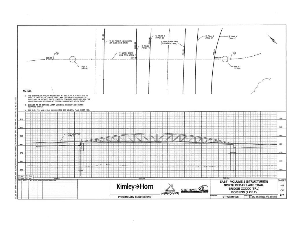
1 FOUNDATION ANALYSIS AND DESIGN REPORT TO: FROM: Mark Bishop, PE, Kimley-Hom and Associates, Inc. Jeffery K. Voyen, PE, American Engineering Testing, Inc. DATE: June 25, 2014 SUBJECT: North Cedar Lake Trail Pedestrian Bridge (Southwest of Penn Station) Southwest Light Rail Transit Project Minneapolis, Minnesota AETNo PROJECT INFORMATION This report provides preliminary foundation recommendations for the pedestrian bridge which is intended to carry the North Cedar Lake Trail over the LRT and freight rail tracks to the southwest of the Penn Station in Minneapolis. The location of the bridge has not been firmly established, although the current layout addressed in this report is presented on attached Figure 1. For the purpose of this report, bottom of foundation elevation is assumed to be about 5 feet below the current grade at the site. The plan and profile sheets from the preliminary bridge plans are attached to this report. The intent of this report is not to serve as a final design report, but a preliminary report to assist advanced design and preliminary pricing. Additional testing and analysis is intended to be performed for final design. The borings performed as of this report which is specific to this bridge were limited to the north side of the existing freight tracks (Minneapolis Park and Recreation Board property). The HCCRA property to the south of the tracks, which represents the east half of the bridge, is wooded; and access to the desired boring locations would have required some tree removal. Therefore, exploration in that area was deferred until advanced design, once the bridge location is firmly established. 2.0 SUBSURFACE EXPLORATION SUMMARY 2.1 Field Scope Four standard penetration test (SPT) borings were drilled and sampled on the north side of the freight tracks in the currently proposed west half of the bridge. The borings are numbered 1241 SW, 1242 SB, 1243 SB, and 1244 SB. The locations of the borings appear on attached Figure Laboratory Scope During laboratory classification logging, water content tests were conducted on cohesive soil samples. The test results appear on the individual boring logs, opposite the samples upon which they were performed.
2 Foundation Analysis and Design Report North Cedar Lake Trail Pedestrian Bridge, Southwest of Penn Station June 25, 2014 Report No AMERICAN ENGINEERING TESTING, INC. 2.3 Methods Standard Penetration Test Borings Logs of the noted borings are attached. The SPT borings were drilled with 3.25 inch diameter hollow stem augers and mud rotary drilling methods. Standard penetration test samples were taken with split-barrel samplers per ASTM: D1586, with the exception that the hammers were calibrated to near N 60 values, consistent with MnDOT requirements. Additional details of the methods used appear on the attached sheet entitled Exploration/Classification Methods. The soils were classified per the Unified Soil Classification System. The Soil Group category per the AASHTO Soil Classification System is also noted. The attached boring logs contain information concerning soil layering, soil classification, geologic description, and moisture condition. Relative density or consistency is also noted for the natural soils, which is based on the standard penetration resistance (N-value). 2.4 Geology/Soils Review About 4 feet to 9 feet of fill is present at the surface; the thickness decreasing to the west. The fill is mostly sand with silt and silty sand, with a lesser amount of clayey sand. Some of the soil includes organic content and roots. Boring 1243 SB included pieces of brick. The N-values suggest relatively good compaction, but the presence of organics indicates that it was not controlled, engineered fill. The underlying natural soils are mostly alluvial (water-deposited). The alluvium is mainly sand and sand with silt, often having significant gravel content. Boring 1244 SB does include some layers of clayey sand and silt at or near the top of the alluvial profile. Glacially-deposited till appears at depth, deeper than elevation 800 feet, except for a thinner interbedded layer at Boring 1244 SB from 19 feet to 24 feet. The till consists of clayey sand, silty sand, sandy lean clay, and lean clay with sand. 2.5 Ground Water Water levels appeared in the boreholes at depths ranging from about 71/z feet to 101/z feet, corresponding to approximate elevation 8481/z feet to 849 feet. As the levels were measured in granular soils, they should reasonably represent the hydrostatic ground-water level for that time and location. Ground-water levels should be expected to fluctuate both seasonally and annually. 3.0 FOUNDATION REVIEW 3.1 Foundation Type In the explored west half of the bridge and retained wall approach area, alluvial sands are present at anticipated foundation grade or are at a reasonable depth below foundation grade such that a local excavate/refill correction operation could be performed to allow spread foundation support. We recommend the footings not be supported on the existing fill due to the intermixed organics Page 2 of 5
3 Foundation Analysis and Design Report North Cedar Lake Trail Pedestrian Bridge, Southwest of Penn Station June 25, 2014 Report No AMERICAN ENGINEERING TESTING, INC. and debris, and due to the potential variation in soil type and compaction level. It is possible that poorer soil conditions will be present on the east side of the bridge. Boring 1025 ST placed in the planned track area to the northeast of the track crossing span did show the presence of buried swamp deposits. Additional soil borings should be performed at final foundation locations during advanced design to explore this condition further. 3.2 Spread Foundation for Bridge and Retained Wall Approaches The alluvial sands are judged competent to support spread foundations. However, we recommend the existing fill not be relied upon for foundation support. Excavation to assumed foundation grade is expected to expose either the fill or the alluvial sandy soils. Where fill is encountered, we recommend excavation of the fill to expose the alluvium. Excavation depth needed at each boring location included in the report is shown on Table 3.2. Boring No. Table 3.2 -Required Excavation Depth Boring Surface Elevation, ft Excavation Depth, ft Excavation Elevation, ft Ground Water Anticipated 1241 SW Yz no 1242 SB \ 6Yz 852Yz no 1243 SB Yz 851 no 1244 SB yes As shown, the excavation in the area of Boring 1244 SB may extend 1 Yz feet to 2 feet below the water level. This boring was completed this June (2014) during a time when ground-water levels are above normal. If standing water is present during construction, we recommend local dewatering be performed as needed to allow observation and verification of a competent excavation bottom. Excavations and subsequent engineered fill placement should maintain m1mmum lateral oversizing of the excavation bottom. This lateral excavation oversizing should be a minimum of 1:l(H:V). The exception would be if organic soils are encountered during the excavation (which is not expected in the area of the four borings). If excavation sides expose organic soils, the lateral excavation bottom oversize requirement should be increased to at least 1. 5: 1 (H: V). Engineered fill placed below foundations should meet the requirements of MnDOT Specification Bl for Granular Borrow. On-site soils could be used, provided they are evaluated at the time of construction to uniformly meet material specifications and to be free of organic soils and Page 3 of 5
4 Foundation Analysis and Design Report North Cedar Lake Trail Pedestrian Bridge, Southwest of Penn Station June 25, 2014 Report No AMERICAN ENGINEERING TESTING, INC. debris. If wet or sensitive excavation bottom conditions exist, it may then be necessary to use Select Granular Borrow (Specification B2) or cleaner sand as the lower lifts of fill. The fill should be compacted in thin lifts, such that the entire lift achieves a minimum compaction level of 98% of the standard maximum dry unit weight per ASTM:D698 (Standard Proctor test). The fill lift thicknesses should be no greater than 12 inches for granular soils and no greater than 8 inches for more clayey/silty soils. The lifts should be thinner than the above if needed to achieve the minimum specified compaction level with the type of compaction equipment being used. 3.3 Spread Foundation Design Considering the preliminary nature of the bridge and approach design, specific foundation load information is not yet available. Advanced design should consider strength resistance and settlement control under axial loads; and for imbalanced/retained loads, resistance to sliding and global stability. For preliminary purposes, the foundations can be sized for an allowable bearing pressure of 4,000 psf (per Allowable Stress Design methods). 3.4 Approach Considerations Fill will be placed between the retained walls leading up to the structured bridge. The fill will impose loads upon underlying soils. However, it is our opinion that trail support over the existing fill would be acceptable with low risk, provided conditions are consistent with that portrayed by the borings. The wall footing excavations will expose the fill along the trench sidewalls and these conditions can be further evaluated during construction. 3.5 Retaining Wall Backfilling Imbalanced retaining walls and abutment/wing walls should be designed to properly resist the lateral pressures exerted. The backfill material should consist of Select Granular Borrow (MnDOT B2), which is modified to containing less than 10% by weight passing the #200 sieve. The "Select Granular Borrow 10% Modified" geometry should be maintained per the requirements shown on attached MnDOT Diagram F-1. However, all excavation backsloping must also meet OSHA requirements and the need for frost zone tapering below the approach pavement. For trail approach performance, frost tapering of the Select Granular Borrow below the trail of lv:loh is recommended within the frost zone (assume a frost zone of 4.5 feet). The backfill should be compacted per the Specified Density Method (MnDOT Fl). The wall design can be based on lateral pressures presented in MnDOT design charts. Page 4 of 5
5 Foundation Analysis and Design Report North Cedar Lake Trail Pedestrian Bridge, Southwest of Penn Station June 25,.2014 Report No AMERICAN ENGINEERING TESTING, INC. I hereby certify that this report was prepared by me or under my direct supervision and that I am a duly Licensed Professional Engineer under Minnesot tatute Section to Name: ~z.;,,-,;~j. ~ ~ Jef ery K. Voyen Date: C::,(z 5"' 6 f License#: Report Reviewed By: --~/L 'll-_.,._ - _ A_, -- f,,l) "'------'-.. {J "---- ~ ~ ~Joseph G. Bentler, PE Attachments: Preliminary Bridge Plan-Profile Sheets Figure 1 - Boring Locations Subsurface Boring Logs Exploration/Classification Methods Boring Log Notes Unified Soil Classification System AASHTO Soil Classification System MnDOT Diagram F-1 Page 5 of 5

6
7

8

9
10
11
12
13
14
15
16

17
18
19 EXPLORATION/CLASSIFICATION METHODS SAMPLING METHODS Split-Spoon Samples (SS) - Calibrated to N 60 Values Standard penetration (split-spoon) samples were collected in general accordance with ASTM: D1586 with one primary modification. The ASTM test method consists of driving a 2" O.D. split-barrel sampler into the in-situ soil with a 140-pound hammer dropped from a height of 30". The sampler is driven a total of 18" into the soil. After an initial set of 6", the number of hammer blows to drive the sampler the final 12" is known as the standard penetration resistance or N-value. Our method uses a modified hammer weight, which is determined by measuring the system energy using a Pile Driving Analyzer (PDA) and an instrumented rod. In the past, standard penetration N-value tests were performed using a rope and cathead for the lift and drop system. The energy transferred to the split-spoon sampler was typically limited to about 60% of its potential energy due to the friction inherent in this system. This converted energy then provides what is known as an N 60 blow count. Most of today's drill rigs incorporate an automatic hammer lift and drop system, which has higher energy efficiency and subsequently results in lower N-values than the traditional N 60 values. By using the PDA energy measurement equipment, we are able to determine actual energy generated by the drop hammer. With the various hammer systems available, we have found highly variable energies ranging from 55% to over 100%. Therefore, the intent of AET's hammer calibrations is to vary the hammer weight such that hammer energies lie within about 60% to 65% of the theoretical energy of a 140-pound weight falling 30". The current ASTM procedure acknowledges the wide variation in N-values, stating that N-values of 100% or more have been observed. Although we have not yet determined the statistical measurement uncertainty of our calibrated method to date, we can state that the accuracy deviations of the N-values using this method are significantly better than the standard ASTM Method. Sampling Limitations Unless actually observed in a sample, contacts between soil layers are estimated based on the spacing of samples and the action of drilling tools. Cobbles, boulders, and other large objects generally cannot be recovered from test borings, and they may be present in the ground even if they are not noted on the boring logs. CLASSIFICATION METHODS Soil classifications shown on the boring logs are based on the Unified Soil Classification (USC) system. The USC system is described in ASTM: D2487 and D2488. Where laboratory classification tests (sieve analysis or Atterberg Limits) have been performed, accurate classifications per ASTM: D2487 are possible. Otherwise, soil classifications shown on the boring logs are visual-manual judgments. Charts are attached which provide information on the USC system, the descriptive terminology, and the symbols used on the boring logs. Visual-manual judgment of the AASHTO Soil Group is also noted as a part of the soil descri~tion. A chart presenting details of the AASHTO Soil Classification System is also attached. The boring logs include descriptions of apparent geology. The geologic depositional origin of each soil layer is interpreted primarily by observation of the soil samples, which can be limited. Observations of the surrounding topography, vegetation, and development can sometimes aid this judgment. WATER LEVEL MEASUREMENTS The ground-water level measurements/comments are shown on the boring logs in the remarks section. The true location of the water table at the boring locations may be different than the water levels measured in the boreholes. This is possible because there are several factors that can affect the water level measurements in the borehole. Some of these factors include: permeability of each soil layer in profile, presence of perched water, amount of time between water level readings, presence of drilling fluid, weather conditions, and use of borehole casing. SAMPLE STORAGE Unless notified to do otherwise, we routinely retain representative samples of the soils recovered from the borings for a period of 30 days. 01REP051C (12/08) AMERICAN ENGINEERING TESTING, INC.
20 BORING LOG NOTES DRILLING AND SAMPLING SYMBOLS Symbol Definition AR: Sample of material obtained from cuttings blown out the top of the borehole during air rotary procedure. B,H,N: Size of flush-joint casing CAS: Pipe casing, number indicates nominal diameter in inches COT: Clean-out tube DC: Drive casing; number indicates diameter in inches DM: Drilling mud or bentonite slurry DR: Driller (initials) DS: Disturbed sample from auger flights DP: Direct push drilling; a inch OD outer casing with an inner 1 Yz inch ID plastic tube is driven continuously into the ground. FA: Flight auger; number indicates outside diameter in inches HA: Hand auger; number indicates outside diameter HSA: Hollow stem auger; number indicates inside diameter in inches LG: Field logger (initials) MC: Column used to describe moisture condition of samples and for the ground water level symbols N (BPF): Standard penetration resistance (N-value) in blows per foot (see notes) NQ: NQ wireline core barrel PD: Plug Drilling (same as RDF) PQ: PQ wireline core barrel RDA: Rotary drilling with compressed air and roller or drag bit. RDF: Rotary drilling with drilling fluid and roller or drag bit REC: In split-spoon ( see notes), direct push and thin-walled tube sampling, the recovered length (in inches) of sample. In rock coring, the length of core recovered (expressed as percent of the total core run). Zero indicates no sample recovered. SS: Standard split-spoon sampler (steel; 1.5" is inside diameter; 2" outside diameter); unless indicated otherwise SU Spin-up sample from hollow stem auger TW: Thin-walled tube; number indicates inside diameter in inches WASH: Sample of material obtained by screening returning rotary drilling fluid or by which has collected inside the borehole after "falling" through drilling fluid WH: Sampler advanced by static weight of drill rod and hammer WR: Sampler advanced by static weight of drill rod 94mm: 94 millimeter wireline core barrel T: Water level directly measured in boring 'v: Estimated water level based solely on sample appearance TEST SYMBOLS Symbol Definition COH: Cohesion, psf (0.5 x qu) CONS: One-dimensional consolidation test y: Wet density, pcf DST: Direct shear test E: Pressuremeter Modulus, tsf HYD: Hydrometer analysis LL: Liquid Limit, % LP: Pressuremeter Limit Pressure, tsf MC: Moisture Content, % OC: Organic Content, % PERM: Coefficient of permeability (K) test; F - Field; L - Laboratory PL: Plastic Limit, % qp: Pocket Penetrometer strength, tsf (approximate) qc: Static cone bearing pressure, tsf qu: Unconfined compressive strength, psf R: Electrical Resistivity, ohm-ems RQD: Rock Quality Designation of Rock Core, in percent (aggregate length of core pieces 4" or more in length as a percent of total core run) SA: Sieve analysis TRX: Triaxial compression test VSR: Vane shear strength, remolded (field), psf VSU: Vane shear strength, undisturbed (field), psf %-200: Percent of material finer than #200 sieve STANDARD PENETRATION TEST NOTES (Calibrated Hammer Weight) The standard penetration test consists of driving a split-spoon sampler with a drop hammer ( calibrated weight varies to provide N 60 values) and counting the number of blows applied in each of three 6" increments of penetration. If the sampler is driven less than 18" (usually in highly resistant material), permitted in ASTM: Dl586, the blows for each complete 6" increment and for each partial increment is on the boring log. For partial increments, the number of blows is shown to the nearest 0.1' below the slash. The length of sample recovered, as shown on the "REC" column, may be greater than the distance indicated in the N column. The disparity is because the N-value is recorded below the initial 6" set (unless partial penetration defined in ASTM: Dl586 is encountered) whereas the length of sample recovered is for the entire sampler drive (which may even extend more than 18"). 01REP052C (7/11) AMERICAN ENGINEERING TESTING, INC.

21
22
23
FOUNDATION ANALYSIS AND DESIGN REPORT
 FOUNDATION ANALYSIS AND DESIGN REPORT TO: FROM: Mark Bishop, PE, Kimley-Hom and Associates, Inc. Jeffery K. Voyen, PE, American Engineering Testing, Inc. DATE: June 25, 2014 SUBJECT: Cedar Lake Trail Pedestrian
FOUNDATION ANALYSIS AND DESIGN REPORT
 FOUNDATION ANALYSIS AND DESIGN REPORT TO: FROM: Mark Bishop, PE, Kimley-Hom and Associates, Inc. Jeffery K. Voyen, PE, American Engineering Testing, Inc. DATE: August 28, 2014 SUBJECT: LRT, Freight Rail,
FOUNDATION ANALYSIS AND DESIGN REPORT. Mark Bishop, PE, Kimley-Hom and Associates, Inc. Jeffery K. Voyen, PE, American Engineering Testing, Inc.
 FOUNDATION ANALYSIS AND DESIGN REPORT TO: FROM: Mark Bishop, PE, Kimley-Hom and Associates, Inc. Jeffery K. Voyen, PE, American Engineering Testing, Inc. DATE: August 28, 2014 SUBJECT: South Connector
FOUNDATION ANALYSIS AND DESIGN REPORT
 FOUNDATION ANALYSIS AND DESIGN REPORT TO: FROM: Mark Bishop, PE, Kimley-Hom and Associates, Inc. Jeffery K. Voyen, PE, American Engineering Testing, Inc. DATE: August 28, 2014 SUBJECT: LRT and Pedestrian
You also requested information regarding a sieve analysis at each boring locations. The test results are attached.
 FORENSICS CONSULTANTS ENVIRONMENTAL GEOTECHNICAL MATERIALS October 4, 2016 Washington County Public Works 11660 Myeron Road Stillwater, MN 55082 Attn: Mr. Marc Briese Re: Additional Borings CSAH 22 (70
EXHIBIT G GEOTECHNICAL REPORT (DRAFT)
") EXHIBIT G GEOTECHNICAL REPORT (DRAFT) APPENDIX 1 PROJECT SITE 'B' B-1 B-2 I-2 B-3 B-4 B-5 I-1 PROJECT LOCATION LEGEND B-1 = APPROXIMATE BORING LOCATION I-1 = APPROXIMATE INFILTRATION
EXHIBIT G GEOTECHNICAL REPORT (DRAFT) APPENDIX 1 PROJECT SITE 'B' B-1 B-2 I-2 B-3 B-4 B-5 I-1 PROJECT LOCATION LEGEND B-1 = APPROXIMATE BORING LOCATION I-1 = APPROXIMATE INFILTRATION
 FIGURES Printed By: aday Print Date: 3/23/2011 12:48:08 PM File Name: \\geodesign.local\files\jobs\m-r\penskeauto\penskeauto-1\penskeauto-1-01\figures\cad\penskeauto-1-01-vm01.dwg Layout: FIGURE 1 VICINITY
GEOTECHNICAL INVESTIGATION I-15 SIGN BRIDGES LAS VEGAS EA JANUARY
 GEOTECHNICAL INVESTIGATION I-15 SIGN BRIDGES LAS VEGAS EA 73171 JANUARY 06 MATERIALS DIVISION STATE OF NEVADA DEPARTMENT OF TRANSPORTATION MATERIALS DIVISION GEOTECHNICAL SECTION GEOTECHNICAL REPORT I-15
Geotechnical Exploration and Evaluation Report
 Geotechnical Exploration and Evaluation Report Nassau Reclaimed Water Main From Radio Avenue to Harts Road Nassau County, Florida CSI Geo Project No.: 71-17-329-04 Client Project No.: JEA 09302-049-01
Site Location. Figure 1: Site Location Map US-24 and I-275 Interchange Ash Township, Monroe County, Michigan
 Site Location 0606 1771 North Dixie Highway Monroe, Michigan 48162 Tel: 734-289-2200 Fax: 734-289-2345 www.manniksmithgroup.com Figure 1: Site Location Map US-24 and I-275 Interchange Ash Township, Monroe
April 7, Webster Street Sub-Surface Stormwater Storage System Bid No Bid Date: 4/13/17 ADDENDUM NO 1
 PUBLIC WORKS DEPARTMENT David A. Jones, P.E., Director April 7, 2017 Webster Street Sub-Surface Stormwater Storage System Bid No. 2017-022 Bid Date: 4/13/17 ADDENDUM NO 1 Please make the following changes
GEOTECHNICAL INVESTIGATION PROPOSED OUTFALL LOCATION CITY OF MORGAN S POINT DRAINAGE HARRIS COUNTY, TEXAS REPORT NO
 GEOTECHNICAL INVESTIGATION PROPOSED OUTFALL LOCATION CITY OF MORGAN S POINT DRAINAGE HARRIS COUNTY, TEXAS REPORT NO. 1140198001 Reported to: SIRRUS ENGINEERS, INC. Houston, Texas Submitted by: GEOTEST
SUBSURFACE INVESTIGATION & GEOTECHNICAL RECOMMENDATIONS PROPOSED MONOPOLE CELL TOWER INDIANAPOLIS, INDIANA A&W PROJECT NO: 15IN0464
 SUBSURFACE INVESTIGATION & GEOTECHNICAL RECOMMENDATIONS PROPOSED MONOPOLE CELL TOWER INDIANAPOLIS, INDIANA A&W PROJECT NO: 15IN0464 PREPARED FOR: AAA DEVELOPMENT AND CONSULTING, INC GREENFIELD, INDIANA
June i TABLE OF CONTENTS
 June 2005 - i - 05-526 TABLE OF CONTENTS SECTION PAGE 1.0 INTRODUCTION... 1 1.1 Purpose of the Investigation... 1 1.2 Description of the Project and Scope of Work... 1 1.3 Site Geology... 1 1.4 Site Description
REPORT OF GEOTECHNICAL EXPLORATION WEST MARJORY AVENUE TAMPA, FLORIDA
 REPORT OF GEOTECHNICAL EXPLORATION WEST MARJORY AVENUE TAMPA, FLORIDA AREHNA PROJECT NO. B-15-008 March 11, 2015 Prepared For: City of Tampa Stormwater Division 306 W. Jackson Street, 6N Tampa, Florida
Geotechnical Engineering Report
 Geotechnical Engineering Report Pavement Subgrade Survey State Highway 125 over Hudson Creek Ottawa County, Oklahoma September 23, 21 Terracon Project No. 415121 Prepared for: Guy Engineering Services,
Subsurface Investigation Report. Proposed New 1-Story Building 6447 Grand Avenue Gurnee, Illinois
 AGI Project No. -11 Subsurface Investigation Report For the Proposed New 1-Story Building 6447 Grand Avenue Gurnee, Illinois Prepared for Mr. Steve Panko Key Development Partners, LLC North State Street,
August 3, 2018 TTL Project No Supplemental Test Borings Cleveland Bulk Terminal Cleveland, Ohio
 1915 North 12 th Street Toledo, OH 43604-5305 T 419-324-2222 F 419-241-1808 www.ttlassoc.com August 3, 2018 TTL Project No. 1706701 Mr. Vito Melilli Coastal Engineer KS Associates, Inc. 260 Burns Road,
mtec REPORT OF GEOTECHNICAL EXPLORATION FTFA Construct Bin Wall at HERD Eglin AFB, Florida
 mtec REPORT OF GEOTECHNICAL EXPLORATION FTFA 14-3001 - Construct Bin Wall at HERD Eglin AFB, Florida MTEC Project Number 2014-101 November 10, 2014 Revised: January 5, 2015 Prepared For: Peterson Engineering,
REPORT OF GEOTECHNICAL EXPLORATION PEPSI PLACE WATER MAIN REPLACEMENT JACKSONVILLE, FLORIDA E&A PROJECT NO CLIENT ID: 4784
 REPORT OF GEOTECHNICAL EXPLORATION PEPSI PLACE WATER MAIN REPLACEMENT JACKSONVILLE, FLORIDA E&A PROJECT NO. 35-55 CLIENT ID: 78 Prepared for: Construction & Engineering Services Consultants, Inc. 93 Baymeadows
GEOTECHNICAL REPORT B-1942
 GEOTECHNICAL REPORT TUSCARORA BRIDGE REPLACEMENT B-1942 E.A. 73561 March 2011 MATERIALS DIVISION STATE OF NEVADA DEPARTMENT OF TRANSPORTATION MATERIALS DIVISION GEOTECHNICAL SECTION GEOTECHNICAL REPORT
Applied GeoScience, Inc Hammond Dr., Suite 6 Schaumburg, Illinois
 AGI Project No. 13-276 Subsurface Investigation Report For the Proposed New Retail Center 9601 South Pulaski Road Evergreen Park, Illinois Prepared for Mr. Feras Sweis FHS Design + Build LLC 2010 West
GEOTECHNICAL SUBSURFACE DATA REPORT
 GEOTECHNICAL SUBSURFACE DATA REPORT SC-41 REPLACEMENT BRIDGE OVER MAIDEN DOWN SWAMP MARION COUNTY, SOUTH CAROLINA PREPARED FOR Mr. Joshua Meetze, E.I.T. RPG-2 GDS South Carolina Department of Transportation
REPORT OF GEOTECHNICAL EXPLORATION BYFORGE ENGINEERING FOR REFERENCE ONLY
 REPORT OF GEOTECHNICAL EXPLORATION BYFORGE ENGINEERING FOR REFERENCE ONLY HERITAGE BAY MASTER PUMP STATION ISSUED FOR BID REPORT OF GEOTECHNICAL EXPLORATION PROPOSED INLINE WASTEWATER BOOSTER STATION Collier
GEOTEK ENGINEERING & TESTING SERVICES, INC. 909 East 50 th Street North Sioux Falls, South Dakota Phone Fax
 GEOTEK ENGINEERING & TESTING SERVICES, INC. 909 East 50 th Street North Sioux Falls, South Dakota 57104 Phone 605-335-5512 Fax 605-335-0773 September 8, 2016 City of Viborg 101 N. Main Street 57070 Attn:
CONTRACT 5E-2 APPENDIX A - TEST HOLE LOGS DYREGROV ROBINSON INC. PORTAGE AVE WINSTON DR BOURKEVALE CAVELL PARKSIDE DR ASSINIBOINE AVE
 APPENDIX A - TEST HOLE LOGS PORTAGE AVE TH -9 CONTRACT E- DR DR BOURKEVALE CAVELL WINSTON DR PARKSIDE DR ASSINIBOINE AVE AUTHORIZED BY: DATE: CONSULTING GEOTECHNICAL ENGINEERS AUTHORIZED /0/ CLIENT DRAWING
REPORT OF GEOTECHNICAL EXPLORATION GLYNN COUNTY DETENTION CENTER GLYNN COUNTY, GEORGIA E&A PROJECT NO
 REPORT OF GEOTECHNICAL EXPLORATION GLYNN COUNTY DETENTION CENTER GLYNN COUNTY, GEORGIA E&A PROJECT NO. - Prepared for: IPG Architects, Inc. Northwood Park Drive Valdosta, Georgia Prepared by: Ellis & Associates,
GEOTECHNICAL REPORT US 93 WILDLIFE UNDERCROSSINGS North of Wells, Nevada E.A July 2009
 GEOTECHNICAL REPORT US 93 WILDLIFE UNDERCROSSINGS North of Wells, Nevada E.A. 73523 July 2009 MATERIALS DIVISION STATE OF NEVADA DEPARTMENT OF TRANSPORTATION MATERIALS DIVISION GEOTECHNICAL SECTION GEOTECHNICAL
REPORT OF GEOTECHNICAL EXPLORATION KINLOCK FM REPLACEMENT NEW MANHOLE STRUCTURE JACKSONVILLE, FLORIDA ECS PROJECT NO A CLIENT ID: 0199
 REPORT OF GEOTECHNICAL EXPLORATION KINLOCK FM REPLACEMENT NEW MANHOLE STRUCTURE JACKSONVILLE, FLORIDA ECS PROJECT NO. 3-6187-A CLIENT ID: 0199 Prepared for: JEA 1 West Church Street Jacksonville, Florida
Geotechnical Engineering Report
 Geotechnical Engineering Report Turner Turnpike Widening Milepost 203 to 210 Drainage Structure Pipe Jacking Creek County, Oklahoma June 1, 2016 Terracon Project No. 04155197 Prepared for: Garver, LLC
REPORT OF GEOTECHNICAL EXPLORATION AND ENGINEERING ANALYSIS
 FIGURE 3 Geotechnical Report (2) REPORT OF GEOTECHNICAL EXPLORATION AND ENGINEERING ANALYSIS RIVER TOWER RESTORATION RIVER TOWER PARK TAMPA, FLORIDA AREHNA PROJECT NO. B-13-002 February 22, 2013 Prepared
GEOTECHNICAL INVESTIGATION MDACC GUHN ROAD FLOOD MITIGATION PROJECT 5610 GUHN ROAD HOUSTON, TEXAS REPORT NO
 GEOTECHNICAL INVESTIGATION MDACC GUHN ROAD FLOOD MITIGATION PROJECT 5610 GUHN ROAD HOUSTON, TEXAS REPORT NO. 1140189301 Reported to: URS CORPORATION Houston, Texas Reported by: GEOTEST ENGINEERING, INC.
GEOTEK ENGINEERING & TESTING SERVICES, INC. 909 East 50 th Street North Sioux Falls, South Dakota Phone Fax
 GEOTEK ENGINEERING & TESTING SERVICES, INC. 909 East 50 th Street North Sioux Falls, South Dakota 57104 Phone 605-335-5512 Fax 605-335-0773 October 28, 2016 City of Vermillion 25 Center Street 57069 Attn:
Earth Mechanics, Inc. Geotechnical & Earthquake Engineering
 Earth Mechanics, Inc. Geotechnical & Earthquake Engineering TECHNICAL MEMORANDUM DATE: June 3, 2009 EMI PROJECT NO: 01-143 TO: COPY: FROM: SUBJECT: John Chun, P.E. / Port of Long Beach (POLB) Jorge Castillo
Preliminary Geotechnical Report
 Preliminary Geotechnical Report Trunk Highway 101 from Pioneer Trail to Lyman Boulevard Chanhassen, Minnesota SEH No. CHANH 114382 March 14, 2011 Table of Contents Certification Page Table of Contents
Subsurface Investigation Report
 AGI Project No. 17-154 Subsurface Investigation Report For the Proposed New One-Story Building Addition 7030 West 111 th Street Worth, Illinois Prepared for T63 Development LLC 11052 Mayflow er Lane Orland
GEOTEK ENGINEERING & TESTING SERVICES, INC. 909 East 50 th Street North Sioux Falls, South Dakota Phone Fax
 GEOTEK ENGINEERING & TESTING SERVICES, INC. 909 East 50 th Street North Sioux Falls, South Dakota 57104 Phone 605-335-5512 Fax 605-335-0773 November 1, 2016 City of Viborg PO Box 56 57070-0056 Attn: Lori
GEOTECHNICAL REPORT US 95 WIDENING ANN ROAD
 GEOTECHNICAL REPORT US 95 WIDENING ANN ROAD to KYLE CANYON ROAD Package 2 E.A. 73627 January 212 MATERIALS DIVISION STATE OF NEVADA DEPARTMENT OF TRANSPORTATION MATERIALS DIVISION GEOTECHNICAL SECTION
GEOTECHNICAL ENGINEERING REPORT
 GEOTECHNICAL ENGINEERING REPORT GRAND AVENUE PEDESTRIAN BRIDGE RELOCATION ROARING FORK RIVER GLENWOOD SPRINGS, COLORADO April 18, 2016 Prepared By: Prepared For: Mr. Bob Pattillo, P.E. Pattillo Associates
SITE INVESTIGATION. Foundation Engineering
 SITE INVESTIGATION Assist. Prof. Berrak TEYMUR Foundation Engineering Analysis Design Construction As a foundation engineer, you need to consider geotechnical/structural issues (involves geology, subsurface
Subsurface Investigations PDCA Professor s Driven Pile Institute. Loren R. Anderson Utah State University June 25, 2015
 Subsurface Investigations PDCA Professor s Driven Pile Institute Loren R. Anderson Utah State University June 25, 2015 Ralph B. Peck (1962) Subsurface engineering is an art; soil mechanics is an engineering
 Appendix A - Vicinity Map Vicinity Map: Palm Beach Gardens City Hall Additions, 000 N Military Trail, Palm Beach Gardens, FL Proposed Location of Police Dept. Attached Addition Proposed Location of New
GEOTECHNICAL REPORT CARSON FREEWAY CLEARVIEW DRIVE GRADE SEPARATION CARSON CITY EA DECEMBER
 GEOTECHNICAL REPORT CARSON FREEWAY CLEARVIEW DRIVE GRADE SEPARATION CARSON CITY EA 72781 DECEMBER 2003 MATERIALS DIVISION STATE OF NEVADA DEPARTMENT OF TRANSPORTATION MATERIALS DIVISION GEOTECHNICAL SECTION
Consultant Specifications for Subsurface Investigation & Geotechnical Analysis and Design Recommendations
 Consultant Specifications for Subsurface Investigation & Geotechnical Analysis and Design Recommendations Mn/DOT Geotechnical Section - Office of Materials & Road Research http://www.mrr.dot.state.mn.us/geotechnical/foundations/tcontract.asp
APPENDIX A DRAINAGE STUDY PHASE 2 ALTERNATIVE IMPROVEMENTS CRYSTAL LAKE ALTERNATIVE 4C IMPROVEMENTS LAKEWOOD PIRATELAND SWASH HORRY COUNTY, SC
 DRAINAGE STUDY PHASE ALTERNATIVE IMPROVEMENTS CRYSTAL LAKE ALTERNATIVE C IMPROVEMENTS ` FOR: LAKEWOOD PIRATELAND SWASH HORRY COUNTY, SC APPENDIX A J-.000 Prepared by: Savannah, GA Charleston, SC Myrtle
Geotechnical Engineering Report
 Geotechnical Engineering Report Turner Turnpike Widening Milepost 210 to 218 Drainage Structure Pipe Jacking Creek County, Oklahoma July 1, 2016 Terracon Project No. 04165017 Prepared for: Benham Tulsa,
Report of Exploratory Test Pits
 Report of Exploratory Test Pits UNF Transportation Projects Stockpile Investigation Osprey Ridge Road Extension Jacksonville, Florida CSI Geo Project No.: 71-17-135-20 Arcadis Project No.: JK017002.0001
GEOTEK ENGINEERING & TESTING SERVICES, INC. 909 East 50 th Street North Sioux Falls, South Dakota Phone Fax
 GEOTEK ENGINEERING & TESTING SERVICES, INC. 909 East 50 th Street North Sioux Falls, South Dakota 57104 Phone 605-335-5512 Fax 605-335-0773 May 10, 2016 Banner Associates, Inc. 2307 W. 57 th Street, Suite
AECOM tel 558 North Main Street fax Oshkosh, Wisconsin 54901
 920.2.0270 tel 8 North Main Street 920.2.021 fax Oshkosh, Wisconsin 4901 May 8, 2012 Mr. James Rabe P.E., CPESC Civil Engineer II City of Oshkosh 21 Church Avenue Oshkosh, WI 490 Subject: Subsurface Exploration
Please include this addendum in your Bid proposal for the above referenced project. Questions are in black ink, and the answers are in red ink.
 JAHarchitects, LLC PROJECT NO. 393 RIVERCREST CDD 11560 RAMBLE CREEK DRIVE, RIVERVIEW FL ADDENDUM TO BID PROJECT: RIVERCREST CDD MULTI PURPOSE FIELD MAINTENANCE BUILDING & DOG PARK POOL & CABANNA JAH PROJECT
GEOTECHNICAL REPORT US 93 WILDLIFE OVERCROSSING At HD SUMMIT North of Wells, Nevada E.A December 2009
 GEOTECHNICAL REPORT US 93 WILDLIFE OVERCROSSING At HD SUMMIT North of Wells, Nevada E.A. 73524 December 2009 MATERIALS DIVISION STATE OF NEVADA DEPARTMENT OF TRANSPORTATION MATERIALS DIVISION GEOTECHNICAL
CONDUCTED FOR: PREPARED FOR: 18 October 2010 YPC Project No. 10GY133
 GEOTECHNICAL EXPLORATION AND ENGINEERING SERVICES REPORT CONDUCTED FOR: Immokalee Stormwater Master Plan Implementation Immokalee, Collier County, Florida PREPARED FOR: Mr. Marc Stonehouse, P. E. Project
PROJECT INFORMATION...
 TABLE OF CONTENTS Page No. PROJECT INFORMATION... 1 PROJECT AUTHORIZATION... 1 PROJECT DESCRIPTION... 1 PURPOSE AND SCOPE OF SERVICES... 1 SITE AND SUBSURFACE CONDITIONS... 3 SITE LOCATION AND DESCRIPTION...
CONDUCTED FOR: PREPARED FOR: 5 May 2016 YPC Project No. 16GY146
 GEOTECHNICAL EXPLORATION SERVICES REPORT CONDUCTED FOR: Collier Boulevard PREPARED FOR: Mr. Christopher L. Johnson Director of Land Development Stock Development, LLC Professional Circle, Suite 01 Naples,
Ardaman & Associates, Inc. Geotechnical, Environmental and Materials Consultants
 SUBSURFACE SOIL EXPLORATION ANALYSIS AND RECOMMENDATIONS PROPOSED WEIRS AT STATIONS 130+00 AND 16+00 DRAINAGE IMPROVEMENTS TO THE FOUR CORNERS MSBU HENDRY COUNTY, FLORIDA Ardaman & Associates, Inc. Geotechnical,
For. Report of Geotechnical Exploration. University of North Florida Parking Lot 47 Jacksonville, Florida
 Report of Geotechnical Exploration For University of North Florida Parking Lot 47 Jacksonville, Florida MAE Project No. 0019-0009 April 5, 2017 Revised: April 6, 2017 Prepared for: Prepared by: Jacksonville,
Exploration, Sampling, and In Situ Soil Measurements. Dr. Omar Al-Hattamleh
 Exploration, Sampling, and In Situ Soil Measurements Dr. Omar Al-Hattamleh Purpose of Soil Exploration Information to determine the type of foundation required (shallow or deep). Information to allow the
Geotechnical Engineering Report Proposed Communications Tower Spain Park Site Hoover, Alabama
 Geotechnical Engineering Report Proposed Communications Tower Spain Park Site Hoover, Alabama July 24, 2014 Terracon Project No. E1145095 Prepared for: The City Of Hoover Hoover, Alabama Prepared by: Terracon
Geotechnical Engineering Report
 Geotechnical Engineering Report Skiatook City Substation Skiatook, Oklahoma October 05, 2017 Terracon Project No. 04175204 Prepared for: GRDA Tulsa, Oklahoma Prepared by: Terracon Consultants, Inc. Tulsa,
TABLE OF CONTENTS 1.0 INTRODUCTION SCOPE OF WORK SUBSURFACE EXPLORATION Sampling Techniques Sample Disposal...
 TABLE OF CONTENTS Page No 1.0 INTRODUCTION... 1 2.0 SCOPE OF WORK... 1 3.0 SUBSURFACE EXPLORATION... 2 3.1 Sampling Techniques... 2 3.2 Sample Disposal... 2 4.0 LABORATORY TESTING... 3 5.0 SUBSURFACE STRATIGRAPHY...
Geotechnical Investigation Long Timber Brewing Building Highway 99 and Kelly Street Monroe, Oregon TABLE OF CONTENTS
 Highway 99 and Kelly Street TABLE OF CONTENTS PROJECT INFORMATION... 1 FIELD EXPLORATION... 1 SITE CONDITIONS... 2 Surface Conditions:... 2 Subsurface Conditions:... 2 FILL.... 2 Topsoil.... 2 Clay Alluvium....
Page 4 Blythe Municipal Airport Project County of Riverside, California December 7, 2015 CTE Job No G
 Geotechnical Investigation Page 4 Blythe Municipal Airport Project County of Riverside, California December 7, 2015 CTE Job No. 40-3264G Laboratory CBR Tests Laboratory CBR tests were performed on samples
WASH STRUCTURE B-420 S EA
 GEOTECHNICAL REPORT US-95 at PIUTE WASH STRUCTURE B-420 S EA 72498 May 2004 MATERIALS DIVISION STATE OF NEVADA DEPARTMENT OF TRANSPORTATION MATERIALS DIVISION GEOTECHNICAL SECTION GEOTECHNICAL REPORT US-95
Presented by: Civil Engineering Academy
 Presented by: Civil Engineering Academy Soil Classification Presented by: Civil Engineering Academy Is an aggregate of loose mineral and organic particles. Exhibits strong and permanent cohesive forces
GEOTECHNICAL REPORT CHEYENNE AVENUE DISTRESS INVESTIGATION
 GEOTECHNICAL REPORT CHEYENNE AVENUE DISTRESS INVESTIGATION and MITIGATION CLARK COUNTY April 2003 MATERIALS DIVISION STATE OF NEVADA DEPARTMENT OF TRANSPORTATION MATERIALS DIVISION GEOTECHNICAL SECTION
Dilatometer Use in Geotechnical Investigations
 Dilatometer Use in Geotechnical Investigations John P. Marshall, P.E. & Robert A. O Berry Marshall Engineering, Inc. 3161 Solomons Island Road, Suite 2 Edgewater, 21037 email: marshallengineering@gmail.com
Geotechnical Investigation Report
 MC Squared, Inc Geotechnical Investigation Report S. Edison Avenue Roadway Improvements City Of Tampa Florida Prepared for: Ms. Barbara Graves City of Tampa DPW Stormwater Engineering 306 E. Jackson St.,6N
SP , Overhead Sign (Metro District) TH94 SB at Stat: Foundations Investigation and Recommendations
 TH94 SB at Stat: Foundations Investigation and Recommendations") Minnesota Department of Transportation MEMO Office of Materials and Road Research Mailstop 645 1400 Gervais Avenue Maplewood, MN 559 Date: September 7 th, To: From: Concur: Subject: Josie Tayse, Project
Minnesota Department of Transportation MEMO Office of Materials and Road Research Mailstop 645 1400 Gervais Avenue Maplewood, MN 559 Date: September 7 th, To: From: Concur: Subject: Josie Tayse, Project
GEOTECHNICAL ENGINEERING REPORT
 GEOTECHNICAL ENGINEERING REPORT 58.6 ROAD (KIMBALL CREEK) 58.9 ROAD TO 58.7 ROAD MESA COUNTY, COLORADO February 9, 2018 Prepared By: Prepared For: Mr. Eric Krch, P.E. SGM, Inc. 744 Horizon Court, Suite
ADDENDUM NO. 1. Clarification/Question/Answer/Updated Plan Sheets
 ADDENDUM NO. 1 DATE: July 20, 2016 INVITATION FOR BID: IFB K160021767 Bellemeade Park Pedestrian Trails and Bridge Project (UPC 107531) DATED: June 28, 2016 RECEIPT DATE: July 28, 2016 @ 2:30 P.M. OPENING
April 21, Odom Investments, Inc. Attn: Mr. Jerry Odom 7100 Westwind Dr., Suite 230 El Paso, TX 79912
 April 21, 2016 Odom Investments, Inc. Attn: Mr. Jerry Odom 7100 Westwind Dr., Suite 230 El Paso, TX 79912 Re: GEOTECHNICAL ENGINEERING REPORT Proposed San Elizario Retail Center Socorro Road & Chicken
May 2, Mr. Tim Kurmaskie, AIA ARCHITECT KURMASKIE ASSOCIATES, INC Washington Street Raleigh, NC
 Mr. Tim Kurmaskie, AIA ARCHITECT KURMASKIE ASSOCIATES, INC. 1030 Washington Street Raleigh, NC 27605-1258 May 2, 2017 Re: Report of Subsurface Investigation Westfield Rehabilitation & Health Care Additions
EXECUTIVE SUMMARY Do not rely on this executive summary Rely on the full report
 EXECUTIVE SUMMARY We have prepared this executive summary solely to provide a general overview. Do not rely on this executive summary for any purpose except that for which it was prepared. Rely on the
Table No. 1: Boring Locations/Elevations by Segment
 Table No. 1: Boring Locations/Elevations by Segment Soil Boring Segment Ground Surface Elevation (ft) Northing Easting B 1 Segment 1 984.6 172544.8 440877.4 B 2 Segment 1 983.3 172429 441711.9 B 3 Segment
SOIL AND FOUNDATION INVESTIGATION PROPOSED DUPLEX 3966 VRAIN STREET DENVER, COLORADO
 SOIL AND FOUNDATION INVESTIGATION PROPOSED DUPLEX 3966 VRAIN STREET DENVER, COLORADO Prepared for: G.J. GARDNER HOMES ATTN: DAVE PAGANO 7660 RALEIGH STREET WESTMINSTER, COLORADO 80030 PROJECT NO. 1090
Geotechnical Engineering Report
 BIG CYPRESS SEMINOLE INDIAN RESERVATION WATER TREATMENT FACILITY October 29, 2015 Terracon Project No. HD155065 Prepared for: REISS ENGINEERING, INC. 1016 Spring Villas Pt. Winter Springs, FL 32708 Prepared
REPORT OF SUBSURFACE EXPLORATION AND GEOTECHNICAL ENGINEERING SERVICES
 REPORT OF SUBSURFACE EXPLORATION AND GEOTECHNICAL ENGINEERING SERVICES FAMILY DOLLAR OF ROCKFORD 09 & CHARLES STREET ROCKFORD, ILLINOIS ECS PROJECT NO. 16:1181 FOR NATIONAL RETAIL DEVELOPMENT LLC CHICAGO,
Geotechnical Engineering Report
 Geotechnical Engineering Report Shaw AFB East Gate Entrance Control Facility Amendment Sumter, South Carolina September 13, 2010 Terracon Project No. 73105020A Prepared for: TranSystems North Charleston,
LETTER OF TRANSMITTAL AS REQUESTED FOR REVIEW AND COMMENT FOR APPROVAL PLEASE RECYCLE
 199 Highland Vista Dr., Suite 170 (703) 726-8030 www.geoconcepts-eng.com TO: LETTER OF TRANSMITTAL Mr. Rob McGinnis FASLA FROM: Rebecca L. Smith-Zakowicz, CPG 108 Second Street, SW, Unit #36 Charlottesville,
Geotechnical Exploration Report Butterfly Branch Pedestrian Bridge Spartanburg, South Carolina S&ME Project No
 S&ME Project No. 16 16 11 Prepared for: City of Spartanburg PO Box 179 90 Prepared by: S&ME, Inc. 01 Zima Park Drive 870 December 5, 016 S&ME Project No. 16-16-11 December 5, 016 City of Spartanburg PO
Geotechnical Engineering Report
 Geotechnical Engineering Report Proposed Retaining Wall 44ARW-1 Interstate 235 between N.W. 50th Street and Interstate 44 Oklahoma City, Oklahoma May 8, 2014 Terracon Project No. 03145071 Prepared for:
HNTB Corporation April 17, 2017 Project No
 www.schonewaldengineering.com HNTB Corporation April 17, 2017 Project No. 16-022 Kittery: Spread Footing 8-foot by 10.5-foot, with the bottom of footing located 6 feet below lowest surrounding finished
APPENDIX A REPORT OF GEOTECHNICAL EXPLORATION
 APPENDIX A REPORT OF GEOTECHNICAL EXPLORATION THIS PAGE IS INTENTIONALLY LEFT BLANK Report of Geotechnical Exploration Proposed Stormwater Drainage Improvements (Segments B-F) Governor Road, La Honda Drive,
LITTLE BENNETT TRAIL CLARKSBURG, MARYLAND
 GEOTECHNICAL ENGINEERING REPORT LITTLE BENNETT TRAIL CLARKSBURG, MARYLAND Consulting Geotechnical Engineers 11127 New Hampshire Ave. Silver Spring, MD 20904 Tel: (301) 754-2882 Fax: (301) 754-2884 1500
Lantz-Boggio Architects, P.C LBA Project No
 SECTION 313430- PART 1 GENERAL 1.1 WORK INCLUDED A. Provide all equipment, material, labor and supervision to design and install Engineered Aggregate Piers for the soil reinforcement. Design shall rely
August 17, DCN Number: ALB07WP001 Revision: 0. Prepared By: 8300 Jefferson NE Suite B Albuquerque, New Mexico 87113
 WORK PLAN ENERGY FUELS RESOURCE CORPORATION URANIUM MILL LICENSING SUPPORT PHASE 1 GEOTECHNICAL INVESTIGATION KLEINFELDER PROJECT NO. 83088 August 17, 2007 DCN Number: 83088.1.4.2-ALB07WP001 Revision:
Site Investigation MUHAMMAD AZRIL HEZMI
 Site Investigation MUHAMMAD AZRIL HEZMI Definition Essential part of the preliminary design workon any important structure in order to provide adequateand reliable geotechnical informationand site condition,
GEOTECHNICAL ENGINEERING REPORT
 GEOTECHNICAL ENGINEERING REPORT Project: NW Bucklin Hill at Silverdale Way NW Project Number: 12023 Prepared for: Barber Development P.O. Box 473 Redmond, WA 98073 Prepared by: South Sound Geotechnical
Typical Subsurface Profile. November 28, 2016
 November 28, 2016 RSCCD Facility Planning, District Construction and Support Services 2323 N. Broadway, Suite 112, Santa Ana, CA 92706 Attn: Re: Ms. Allison Coburn Facilities Project Manager P: (714) 480-7530
GEOTECHNICAL ENGINEERING REPORT. KU Parking Lot 300E Southeast of Lied Center Lawrence, Kansas. Project No. D16G1696. KU No. Lz_n/11062.
 GEOTECHNICAL ENGINEERING REPORT KU Parking Lot 300E Southeast of Lied Center Lawrence, Kansas April 1, 2016 Prepared for: University of Kansas Bartlett & West Prepared by: GeoSource, LLC April 1, 2016
GEOTECHNICAL ENGINEERING REPORT
 GEOTECHNICAL ENGINEERING REPORT PROJECT MINECRAFT ACCESS ROAD BOYDTON PLANK ROAD DINWIDDIE COUNTY, VIRGINIA JOB NUMBER: 37775.003 PREPARED FOR: DINWIDDIE COUNTY PO BOX 70 DINWIDDIE COUNTY, STATE 23841
SITE INVESTIGATION Validation and Interpretation of data
 SITE INVESTIGATION Validation and Interpretation of data Dr. G.Venkatappa Rao The Impact 1 The Need To determine the type of foundation To assess bearing capacity/settlement Location of Ground water table,issues
B. The Bidder shall acknowledge receipt of this Addendum in the appropriate space on the Bid Form.
 City of Casper Baler Building / MRF Expansion DOCUMENT 9113 ADDENDUM.1 ADDENDUM NUMBER: 1.2 PROJECT INFORMATION A. Project Name: Baler Building / MRF Expansion B. Owner: City of Casper C. Architect: Hein
3. FIELD INVESTIGATION PROGRAM
 Department of Public Works U.S. Army Corps of Engineers Phase 1B Geotechnical Investigation Geotechnical Data Report 3.3 FIELD METHODS AND PROCEDURES 3. FIELD INVESTIGATION PROGRAM The borings were advanced
PROPOSED CONDOS 1129 Victoria Drive, Dunedin Parcel: , Pinellas County Geotechnical Services June Report No.
 Central Florida Testing Laboratories, Inc. Testing, Development and Research 12625-40th Street North Clearwater, Florida 33762 ENGINEERING BUSINESS NO. 1066 GEOLOGY BUSINESS NO. 224 TAMPA BAY AREA (727)
PAVEMENT DESIGN SUMMARY TANGERINE ROAD CORRIDOR PROJECT INTERSTATE 10 TO LA CANADA DRIVE PIMA COUNTY, ARIZONA
 PAVEMENT DESIGN SUMMARY TANGERINE ROAD CORRIDOR PROJECT INTETATE 10 TO LA CANADA DRIVE PIMA COUNTY, ARIZONA Terracon Project No. 3105079, Revision 3 1.0 INTRODUCTION This report presents the results of
Applied GeoScience, Inc Hammond Dr., Suite 6 Schaumburg, Illinois
 AGI Project No. 13-109B Subsurface Investigation Report For the Proposed Roosevelt Middle School Site Improvements 7560 Oak Avenue River Forest, Illinois Prepared for Mr. Jerry Pilipowicz Terra Engineering,
Results of Onsite Percolation Testing Ellis Commons Senior Housing Development APN City of Perris, California
 Lansing Companies 12671 High Bluff Drive, Suite 150 San Diego, California 92130 April 18, 2017 Project No. 11607.001 Attention: Subject: References: Mr. Casey Malone Results of Onsite Percolation Testing
November 13, Eckas Water 1514 Ambrosia Court Fort Collins, Colorado Attn: Mr. Wayne Eckas
 November 13, 2018 Eckas Water 1514 Ambrosia Court Fort Collins, Colorado 80526 Attn: Mr. Wayne Eckas (wayne@eckaswater.com) Re: Geotechnical Subsurface Exploration Walker Recharge Pipeline Project Morgan
624 Water Street Prairie du Sac, Wisconsin Phone Fax GEOTECHNICAL REPORT PREPARED FOR:
 624 Water Street Prairie du Sac, Wisconsin 53578 608.644.1449 Phone 608.644.1549 Fax www.edgeconsult.com GEOTECHNICAL REPORT PREPARED FOR: WEST BRANCH DT (IA-00-5315) EDGE PROJECT NUMBER: 8593 JANUARY