Hervé YESOU Claire HUBER, Henri GIRAUD, Mathias STUDER, Sadri HAOUET, Paul de FRAIPONT Maria VIRELLI & Yves Louis DESNOS
|
|
|
- Darcy Wilkinson
- 6 years ago
- Views:
Transcription
1 Mapping water bodies exploited multi-sensors and multi resolution optical and SAR data: gained experience from plain flood monitoring in Western Europe and Asia Hervé YESOU Claire HUBER, Henri GIRAUD, Mathias STUDER, Sadri HAOUET, Paul de FRAIPONT Maria VIRELLI & Yves Louis DESNOS SERTIT, France, ASI, Italy, ESA-ESRIN Mapping Water Bodies from Space - MWBS 2015 ESA ESRIN, March
2 Context: better understanding in of water bodies dynamic (water cycle and services) Test site Alsatian plain flood & Yangtze intermediate basin Dynamic of water bodies EO time series description/access Sentinel 1 versus Envisat ASAR Challenging problems, submerged /floating vegetation, mud banks Water bodies from time series Validation via multi resolution approach Indicators derived from times series Perspectives recommendations Mapping Water Bodies from Space - MWBS 2015 ESA ESRIN, March
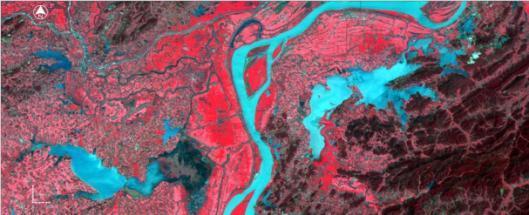
3 Test sites: Poyang Lake (PR China), Alsatian Flood Plain (Fr) Poyang lake, Monsoon lake 15 years of monitoring Mapping Water Bodies from Space - MWBS 2015


4 Test sites: Poyang Lake (PR China), Alsatian Flood Plain (Fr) Poyang lake, Monsoon lake 15 years of monitoring Alsatian Flood plain, less regularly monitor area, but lot of experiment, SPOT Take Five, Pleiades, CSK, Terra SAR, Mapping Water Bodies from Space - MWBS 2015
 reservoir : 1084 km 2 2 to 2.")
5 Poyang study context: Yangtze middle watershed Diversity of types of water bodies, narrow reservoir, large flat depression, etc.. water surface extent behaviors, depending of the season, size factor 5 huge water height variations from 40 to 1 m depending of the water body 3 Gorges Reservoir (3G) reservoir : 1084 km 2 2 to 2.5km width, 40m of annual water height variations Yangtze river: 1-2 km, 9-12m of annual water height variations Dongting Lake: km 2, 9-12m of annual water height variations Poyang Lake: km 2, 9-12m of annual water height variations Anhui lakes: > km 2, 1-3 m of annual water height variations


6 Context: Yangtze river s monsoons lakes monitoring 6000 Lakes, pound, reservoirs 25% freshwater of SE Asia 1 ha to 3500 km 2 Wucheng/Shenjiang Lakes Poyang lake Dongting Lake Poyang lake Large flooded lakes: % of area, 2 majors and 4 small ones Water services: inhabitants Public health Biodiversity stakes Whithin climate change and water management (3GD)


7 Acknowledgement No product without raw material!!!!!! Major pillars : ESA MOST DRAGON ( and more!!) CNES télé-épidémiologie and SWOT ( RTU + Take 5) Others very valuable contributions: - ASI for CSK time series , DLR for Tandem X and multimode data access - Deimos - etc 7

8 Frequency of inundation(8 dates) Water monitoring Alsatian Plain flood TAKE5 SPOT4 exploitation Possibility to follow very small wetlands complex presenting in fact an unexpected/unknown (?) dynamic.

9 Interest of High temporal revisit for monitoring hydrological behaviors Intra annual changes Change within 10 days Change within 40 days 9

10 Interest of High temporal revisit for monitoring hydrological behaviors Inter annual changes 1626 km 2 CSK Mapping Water Bodies from Space - MWBS 2015

11 Interest of High temporal revisit for monitoring hydrological behaviors Inter annual changes 2718 km 2 Sentinel Mapping Water Bodies from Space - MWBS 2015
 Near Half SAR")

12 Monitoring water bodies based on EO resource Request to a secured resource allowing to monitoring large areas with a short revisiting time (10 days) Near Half SAR and optic: =>ENVISAT, Beijing1 and HJ thanks to DRAGON + opportunistic approach to insure revisit, AO JAXA, DEIMOS, TakeFive, AO CSK ASI Open EO database, MODIS, Landsat 46,5 53,5
 Moving from MR to HR, SPOT 4 TakeFive, HJ1A, preparing Sentinel 2 venue Archive TerraSAR, New modes TerraSAR TandemX Cosmo Skymed from ASI (supporting Envisat")
13 Sentinel 1 Monitoring water bodies based on EO resource Request to a secured resource allowing to monitoring large areas with a short revisiting time (10 days) Moving from MR to HR, SPOT 4 TakeFive, HJ1A, preparing Sentinel 2 venue Archive TerraSAR, New modes TerraSAR TandemX Cosmo Skymed from ASI (supporting Envisat Gap)

14 Integration of Sentinel 1 data within the monitoring scheme Poyang lake is one of the rare site that is covered by systematic acquisition as viewed in the Sentinel Scientific Hub 14 Mapping Water Bodies from Space - MWBS 2015
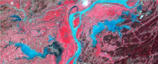
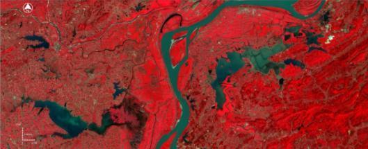
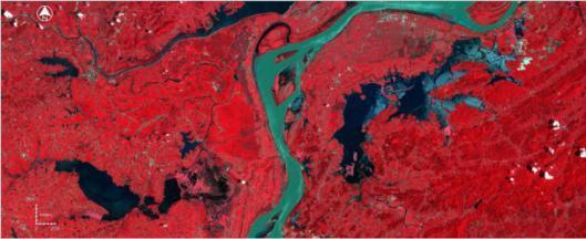
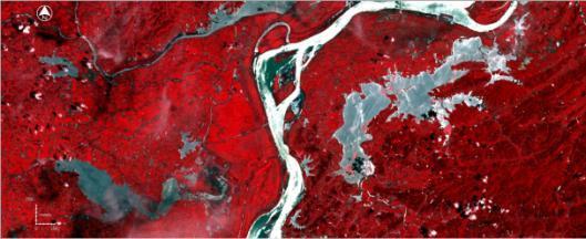
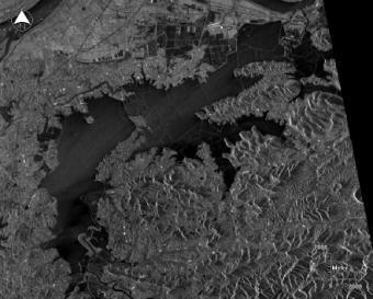
15 Comparison Sentinel1 IWS With ENVISAT ASAR WSM and APP modes over Poyang Lake, PR China 15

16 In term of swath 41 ASAR WSM ENVISAT 400 km ENL 10.5 Sentinel km ENL: 4.9 ASAR APP S4 ENVISAT 88 km ENL

17 17 Land/water surfaces discrimination Major land use such as town, network, infrastructure, agricultural parceling

18 18 Ship detection Land/water surfaces discrimination Major land use such as town, network, infrastructure
19 Recognition of water surface water flooded vegetation and floating vegetation Mapping Water Bodies from Space - MWBS

20 Recognition of water surface water flooded vegetation and floating vegetation Sentinel1 VV less apparent water than on VH Mapping Water Bodies from Space - MWBS
21 Sentinel1 band C VV = CSK band X HH Mapping Water Bodies from Space - MWBS


22 Recognition of water surface water flooded vegetation and floating vegetation Nymphoides Pelatum Mapping Water Bodies from Space - MWBS

23 Recognition of water surface water flooded vegetation and floating vegetation Jacynth Mapping Water Bodies from Space - MWBS

24 CSK Shenjiang Lake Anhui Pr, PR CHina 24

25 Recognition of water surface Wet area after water redraw Mapping Water Bodies from Space - MWBS

26 Recognition of water surface Wet area after water redraw Transitional areas between dry land and open water surface in very flat areas 26
27 Water extraction from Sentinel 1, CSK, HJ1A Time series over Poyang Lake and Anhui lakes, PR China 27
28 HR exploited dataset: HJ Chinese satellite 400 km swath: large diversity of lanscapes HJ1 A/B Daily or every 2 days 400*400 km 30m 28 Mapping Water Bodies from Space - MWBS 2015


29 HR exploited dataset: HJ Chinese satellite 400 km swath: large diversity of lanscapes HJ1 Availability A/B of HJ data over Poyang and Anhui lakes Daily or every 2 days 400*400 km 30m 29 Mapping Water Bodies from Space - MWBS 2015


30 High variability of spectral answer and contrast land/water Shenjian Lake, Anhui Province 30 Mapping Water Bodies from Space - MWBS 2015

31 Poyang lake CSK time series January to December


32 Shenjiang lake CSK time series

33 Sentinel 1: High temporal revisit T0, +5,


34 Sentinel 1-A 27/10/2014 VH/VV Sentinel 1-A 08/11/2014 VH/VV Sentinel 1-A 13/11/2014 VH/VV Sentinel 1-A 20/11/2014 VH/VV Sentinel 1-A 25/11/2014 VH/VV Sentinel 1-A 02/12/2014 VH/VV Sentinel 1-A 07/12/2014 VH/VV Sentinel 1-A 14/12/2014 VH/VV Sentinel 1-A 19/12/2014 VH/VV Sentinel 1-A 26/12/2014 VH/VV 27/10/14 S -1A 1380 km² 08/11/14 S -1A 1871 km² 13/11/14 S -1A 1844 km² 20/11/14 S -1A 1417 km² 25/11/14 S -1A 1485 km² 02/12/14 S -1A 1475 km² Time series of water surfaces Example with Sentinel-1a 07/12/14 S -1A 1514 km² 14/12/14 S -1A 1324 km² 19/12/14 S -1A 1341 km² 26/12/14 S -1A 1048 km²
 or VHR Optical (Pleaides, Kompsat) imagery allow to validate the HR derived flood extent Mapping Water Bodies from Space - MWBS 2015")
35 Validation approach Multi source & multiscale optical and SAR SPOT4/ HJ/Deimos and Pleiades HR TerraSAR, Wide ScanSAR to Staring Spot Light VHR SAR (CSK, Multi mode TerraSAR) or VHR Optical (Pleaides, Kompsat) imagery allow to validate the HR derived flood extent Mapping Water Bodies from Space - MWBS 2015
 Wide Scan SAR 200*200 km 2, 30 m Strip Map mode : 30*50 km 2, 3m SpotLight mode : 5*10 km 2, 1m Staring SpotLight : 3*4 km")
36 Validation of water bodies delineation Based on HR/VHR multi resolution approach Stripmap (SM) / Spotlight standard (SL) / Staring Spotlight (ST) Wide Scan SAR 200*200 km 2, 30 m Strip Map mode : 30*50 km 2, 3m SpotLight mode : 5*10 km 2, 1m Staring SpotLight : 3*4 km 2, 25 cm


37 New TerraSAR X Starring Spot Light images

38 Classical TerraSAR X Strip map images


39 Multi resolution analysis for water extraction validation Muttersoltz, Alsatian flood Plain Comparison TS Staring Spot Light and Strip map Temporal effect and resolution 39 artefact

40

 Mapping Water")
41 Ends: Water surfaces monitoring Analysis of temporal variations of water surfaces from 2000 to Our core information is 15 years of surface extents with a high frequency scoring (10 days in average) Mapping Water Bodies from Space - MWBS 2015


42 Water surfaces monitoring Both in spatial and temporal domains Analysis of temporal variations of water surfaces from 2000 to 2014 Normal hydrological year, wetness and dryer successions => Trends analysis in conjunction with meteo parameters... Mapping Water Bodies from Space - MWBS 2015


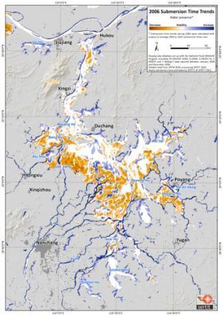


43 Water extent monitoring: Submersion time, occurrence maps Yearly time of submersion Yearly Residual analysis


44 Water extent monitoring: Submersion time: residual analysis Water extent monitoring: Submersion time: residual analysis Ten years averaged of time of submersion Given year: 2014 Yearly Residual analysis
45 Water extent monitoring: Submersion time: residual analysis 45
46 Complementarity SAR Optical HR High complementary-synergy Temporal: Long term few weeks/month with none exploitable Optical data Short term: increase the revisit, that interesting because evolution in less than 5 days (multiscale) => More accurate indicators (be careful with trends motions ) Thematic: - Optical : - Vegetation on optical: flooded, submerged floating vegetation - Water quality Be careful with scale of analysis (Vegetation versus Modis, versus SPOT 20% break each time ).. Water bodies monitoring request regular and long term time series, continuity and consistency are key words Mapping Water Bodies from Space - MWBS
47 Perspectives and recommendations Sentinel1 : systematic VV/VH rather than HH/HV!!!! More global coverage.. Poyang is covered by S1 but only one major sites over hundreds, Sentinel 2: the systematic will be really systematic all around the world.. And at which time Pursuit of the synergy approach with Sentinel3 OCLI (and other L8, Proba 100m), Integrate as much as possible others source of information, such as water height (Jason, Altika, coming S3 and Jason CS before SWOT 2020) Mapping Water Bodies from Space - MWBS

48 Thanks you Questions? YESOU, 2006


 +33 (0)3 68")
49 L ESPACE AU SERVICE DE LA TERRE Herve YESOU SERTIT Université de Strasbourg Institut Telecom Physiques Strasbourg Parc d'innovation 300, Bd Sébastien Brant BP F Illkirch Graffenstaden +33 (0) (Tel) +33 (0) (Fax)
Rice crop monitoring using EO data in the Mekong Delta, Vietnam
 The 10th GEOSS Asia-Pacific Symposium WG5: Agriculture and Food Security Hanoi, 18-20 th, Sep. 2017 Rice crop monitoring using EO data in the Mekong Delta, Vietnam Lam Dao Nguyen, Hoang Phi Phung, Dang
Potential of Pleiades HR data for large gathering monitoring, within security and humanitarian context. H. Yésou SERTIT
 Expectations and hopes of Pleiades HR data for large gathering monitoring Potential of Pleiades HR data for large gathering monitoring, within security and humanitarian context H. Yésou SERTIT GT2 Risks
GEOGLAM international cooperation activities
 GEOGLAM international cooperation activities Chris Justice Center for Global Agricultural Monitoring and Research Dept. of Geographical Sciences University of Maryland GEO: an International Coordinating
Use of Earth Observation Data for Water Resources Management by the Nile Basin Initiative. - Tigernet Project
 Use of Earth Observation Data for Water Resources Management by the Nile Basin Initiative. - Tigernet Project By Milly Mbuliro GIS/ Remote Sensing Specialist Nile Basin Initiative Secretariat 25-27 March,
Integration methods for forest degradation assessment and change monitoring
 VTT TECHNICAL RESEARCH CENTRE OF FINLAND LTD Joint GFOI / GOFC-GOLD / CONABIO / SilvaCarbon R&D Expert and Capacity Building workshop on: Regional solutions to forest type stratification and characterising
Land use change and rice crop monitoring in the Mekong Delta, Vietnam
 International Meeting on Land Use and Emissions in South/Southeast Asia Ho Chi Minh City, 17-19 October 2016 Land use change and rice crop monitoring in the Mekong Delta, Vietnam Nguyen Lam-Dao, Phung
Application of PALSAR data to classify vegetation in an anthropogenically affected wetland area in Central Spain (Las Tablas de Daimiel)
") Rhodes, Greece, Application of PALSAR data to classify vegetation in an anthropogenically affected wetland area in Central Spain (Las Tablas de Daimiel) Thomas Schmid 1, Magaly Koch 2, Jesús Solana 3 and
Rhodes, Greece, Application of PALSAR data to classify vegetation in an anthropogenically affected wetland area in Central Spain (Las Tablas de Daimiel) Thomas Schmid 1, Magaly Koch 2, Jesús Solana 3 and
MONITORING OF CROP GROWTH AND SOIL MOISTURE RETRIEVAL USING NISAR DATA. HARI SHANKER SRIVASTAVA Indian Institute of Remote Sensing (IIRS),
,") NISAR Science Workshop 2015 Space Applications Centre MONITORING OF CROP GROWTH AND SOIL MOISTURE RETRIEVAL USING NISAR DATA HARI SHANKER SRIVASTAVA Indian Institute of Remote Sensing (IIRS), Indian Space
NISAR Science Workshop 2015 Space Applications Centre MONITORING OF CROP GROWTH AND SOIL MOISTURE RETRIEVAL USING NISAR DATA HARI SHANKER SRIVASTAVA Indian Institute of Remote Sensing (IIRS), Indian Space
FOREST AND FOREST CHANGE MAPPING WITH C- AND L-BAND SAR IN LIWALE, TANZANIA
 FOREST AND FOREST CHANGE MAPPING WITH C- AND L-BAND SAR IN LIWALE, TANZANIA J. Haarpaintner a, C. Davids a, H. Hindberg a, E. Zahabu b, R.E. Malimbwi b a Norut, P.O. Box 6434, Tromsø Science Park, N-9294
Oil & Gas Industry. Solutions from the space. Satellite applications in support to
 Satellite applications in support to Oil & Gas Industry Solutions from the space RARTEL S.A. 70 Dr. Iacob Felix, 011041, Bucharest, Romania Phone: +4021 3196804 Fax: +40213196806 www.rartel.ro Summary
DMC 22m Sensors for Supertemporal Land Cover Monitoring. Gary Holmes DMC International Imaging Ltd June 2014
 DMC 22m Sensors for Supertemporal Land Cover Monitoring Gary Holmes DMC International Imaging Ltd June 2014 DMC 2 nd Generation Satellites UK-DMC2 and Deimos-1 launched 29 th July 2009 650km swath width
User Awareness & Training: LAND. Tallinn, Estonia 9 th / 10 th April 2014 GAF AG
 User Awareness & Training: LAND Tallinn, Estonia 9 th / 10 th April 2014 GAF AG Day 2 - Contents LAND (1) General Introduction to EO and the COPERNICUS Sentinel Programme Overview of COPERNICUS/GMES LAND
UrtheCast s Vision for the Democratization of Earth Observation
 UrtheCast s Vision for the Democratization of Earth Observation Fabrizio Pirondini, CEO Deimos Imaging & GM Earth Observation UrtheCast Geospatial World Forum 2016, Rotterdam, The Netherlands, 23 May 2016
A global perspective on land use and cover change
 A global perspective on land use and cover change Alan Belward The Global Environment Monitoring Unit Institute for Environment and Sustainability European Commission Joint Research Centre 21027 Ispra
Intersection of SAR imagery with medium resolution DEM for the estimation of regional water storage changes
 Intersection of SAR imagery with medium resolution DEM for the estimation of regional water storage changes Sonya Spiridonova 1, Karin Hedman 1, Florian Seitz 2 1 Earth Oriented Space Science and Technology
Issues include coverage gaps, delays, measurement continuity and consistency, data format and QC, political restrictions
 Satellite-based Estimates of Groundwater Depletion, Ph.D. Chief, Hydrological Sciences Laboratory NASA Goddard Space Flight Center Greenbelt, MD Groundwater Monitoring Inadequacy of Surface Observations
Global Water Initiative Team Project
 Global Water Initiative Team Project International Space University International, Intercultural, interdisciplinary (3Is) since 1987 UNCOPUOS Scientific and Technical Subcommittee 3 February 2015 GLOBAL
Agata Priolo
 Awareness & Demonstration: EMERGENCY Services Warsaw Poland 25 th June 2014 Agata Priolo agata.priolo@e-geos.it November 26th, 2012 16:30 UTC After heavy rain, rivers were overflowing. The Severn River
The Seven Year Itch. A story by Jose Achache. Starring. Now Playing at The 27 th CEOS SIT La Jolla, California. GEO Secretariat
 The Seven Year Itch A story by Jose Achache Starring Now Playing at The 27 th CEOS SIT La Jolla, California GEOSS has been building-up on 3 Pillars 1. Coordinated Data Access 2. Open Data Policy 3. Political
LAND AND WATER - EARTH OBSERVATION INFORMATICS FSP
 Earth Observation for Water Resources Management Arnold Dekker,Juan P Guerschman, Randall Donohue, Tom Van Niel, Luigi Renzullo,, Tim Malthus, Tim McVicar and Albert Van Dijk LAND AND WATER - EARTH OBSERVATION
GeoCarb. PI: Berrien OU (Leadership, science analysis)
") PI: Berrien Moore @ OU (Leadership, science analysis) Partner Institutions: Lockheed-Martin (instrument) CSU (Algorithms) NASA Ames (Validation) GeoCarb A NASA Earth-Ventures mission, awarded in Dec 2016,
PI: Berrien Moore @ OU (Leadership, science analysis) Partner Institutions: Lockheed-Martin (instrument) CSU (Algorithms) NASA Ames (Validation) GeoCarb A NASA Earth-Ventures mission, awarded in Dec 2016,
Integration of SAR multi-frequency and optical data for the retrieval of soil moisture and vegetation water content
 Integration of SAR multi-frequency and optical data for the retrieval of soil moisture and vegetation water content A. Padovano 1,2, F. Greifeneder 1, R. Colombo 2, G. Cuozzo 1, C. Notarnicola 1 1 - Eurac
DISASTER RESPONSE IN AFRICA BY THE INTERNATIONAL CHARTER
 DISASTER RESPONSE IN AFRICA BY THE INTERNATIONAL CHARTER Ahmed Mahmood *, Canadian Space Agency, Saint-Hubert (Quebec), Canada, J3Y 8Y9, Ahmed.Mahmood@space.gc.ca Eliane Cubero-Castan, Centre National
Numerical modeling of reducing total nitrogen through inflow from channels in Datong Lake, China
 Numerical modeling of reducing total nitrogen through inflow from channels in Datong Lake, China Q. ZHOU1, W.R. HUANG1*, N.Q. ZHOU1, F. TENG2, B.B. WANG2, X.Q. LIU2, S. XIE2, X.P. SHEN2 1 Department of
Conference Title: 2016 CoRP Symposium. Author(s): Kristofer lasko, Colin Miller
: Kristofer lasko, Colin Miller") Conference Title: 2016 CoRP Symposium Author(s): Kristofer lasko, Colin Miller Title: A bottom-up approach to characterizing crop residue burning practices and estimating resultant emissions variations
Conference Title: 2016 CoRP Symposium Author(s): Kristofer lasko, Colin Miller Title: A bottom-up approach to characterizing crop residue burning practices and estimating resultant emissions variations
Forest Changes and Biomass Estimation
 Forest Changes and Biomass Estimation Project Title: Comparative Studies on Carbon Dynamics in Disturbed Forest Ecosystems: Eastern Russia and Northeastern China Supported by NASA Carbon Cycle Science
Application of Space Technology to Water Resources Management & Dragon Project. Li Jiren. Digital Basin Research Centre Institute of Digital china
 Application of Space Technology to Water Resources Management & Dragon Project Li Jiren Digital Basin Research Centre Institute of Digital china 1. Application of space technology to water resources management
Combining Moderate-Resolution Time-Series RS Data from SAR and Optical Sources for Rice Crop Characterisation: Examples from Bangladesh
 Chapter 4 Combining Moderate-Resolution Time-Series RS Data from SAR and Optical Sources for Rice Crop Characterisation: Examples from Bangladesh Andrew Nelson, Mirco Boschetti, Giacinto Manfron, Franceco
 FP7- SPA.2013.1.1-06: Stimulating development of downstream services and service evolution. Contract N : 606983 A downstream service to support agro-production, planning and policy http://www.ermes-fp7space.eu/
Polar Space Task Group Permafrost Review of Requirements, Achievements and Expected Data
 Polar Permafrost Review of Requirements, Achievements and Expected Data Annett Bartsch Central Institute for Meteorology and Geodynamics, Vienna, Austria PSTG 6, ESTEC, Sept., 2016 Developments since last
The role of Remote Sensing in Irrigation Monitoring and Management. Mutlu Ozdogan
 The role of Remote Sensing in Irrigation Monitoring and Management Mutlu Ozdogan Outline Why do we care about irrigation? Remote sensing for irrigated agriculture What are the needs of irrigators? Future
Status of the GSNL initiative
 Status of the GSNL initiative Stefano Salvi Chair of the Supersites Advisory Committee CEOS WG Disasters meeting #6, Vancouver, September 2016 The GSNL initiative A voluntary international partnership
Mapping water constituents concentrations in estuaries using MERIS full resolution satellite data
 Mapping water constituents concentrations in estuaries using MERIS full resolution satellite data David Doxaran, Marcel Babin Laboratoire d Océanographie de Villefranche UMR 7093 CNRS - FRANCE In collaboration
Towards an operational observing system to monitor fossil CO 2 emissions
 Towards an operational observing system to monitor fossil CO 2 emissions Y. Meijer (1), P. Ciais (2), M. Drinkwater (1), P. Ingmann (1), A. Loescher (1), B. Sierk (1), and P. Silvestrin (1) (1) ESA, Noordwijk,
Summary of the socio-economic impact of Copernicus in the EU
 Summary of the socio-economic impact of Copernicus in the EU ESA Since the entry into service of Copernicus first satellite, Sentinel-1A, in 2014, the impacts of the programme are witnessed beyond the
Capacity building for Environmental observations in Finland CLEO workshop Inari, Finland June 2-3, 2016
 Capacity building for Environmental observations in Finland CLEO workshop Inari, Finland June 2-3, 2016 Saku Anttila Finnish Environment Institute Finnish Environment Institute SYKE SYKE is an environmental
Forest and Land Cover Monitoring by Remote Sensing Data Analysis
 Low Carbon Asia Research Network (LoCARNet) 3rd Annual Meeting Bogor, Indonesia November 24 26, 2014 Forest and Land Cover Monitoring by Remote Sensing Data Analysis Muhammad Ardiansyah Center for Climate
MONITORING LAND USE AND LAND USE CHANGES IN FRENCH GUIANA BY OPTICAL REMOTE SENSING
 MONITORING LAND USE AND LAND USE CHANGES IN FRENCH GUIANA BY OPTICAL REMOTE SENSING Photo : Valéry Gond Photo : Valéry Gond Photo Photo : Gaëlle : : Valéry VERGER Gond Gaëlle VERGER ONF, French National
TAKING STOCK OF OUR FORESTS
 Measurement, Reporting and Verification (MRV) systems are expected to be a crucial part of any future international climate agreement, including Reducing Emissions from Deforestation and forest Degradation,
Title: CEDEX Proposal for Use. of CHRIS imagery for Monitoring. Authors: Spain) Topic/subtopic
 Topic/subtopic") Title: CEDEX Proposal for Use of CHRIS imagery for Monitoring oring Ecological Water Quality in smallest Mediterranean Reservoirs integrated in the Intercalibration Exercise of WFD Implementation Process
Title: CEDEX Proposal for Use of CHRIS imagery for Monitoring oring Ecological Water Quality in smallest Mediterranean Reservoirs integrated in the Intercalibration Exercise of WFD Implementation Process
Project WODA: Water Over Abstraction & Illegal Abstraction Detection and Assessment. Pilot Feasibility Study Lombardy
 Project WODA: Water Over Abstraction & Illegal Abstraction Detection and Assessment Pilot Feasibility Study Lombardy Final Report: March 2016 Document change log Version Date Comments 1.0 27/11/15 D. Bellingeri:
Shinichi Sobue, Kei Oyoshi, Lam Dao Nguyen and K.R. Manjunath. On behalf of Asia RiCE team in GEOGLAM
 ASIA RICE CROP TEAM (ASIA-RICE) ACTIVITY IN GEO GLAM Shinichi Sobue, Kei Oyoshi, Lam Dao Nguyen and K.R. Manjunath On behalf of Asia RiCE team in GEOGLAM 1 Asia-RiCE for GEOGLAM (Global Agriculture Monitoring)
Some aspects of the sediment transit on the Mekong river in relation with hydropower development
 Some aspects of the sediment transit on the Mekong river in relation with hydropower development Daniel Loudière Société Hydrotechnique de France A presentation in three parts - the situation when starting
Dong Zheren Chairman of Global Water Partnership - China Global Water Partnership - China
 Ecological Compensation for Dammed Rivers Dong Zheren Chairman of Global Water Partnership - China Global Water Partnership - China Outline 1. The Stresses of Dams on River Ecosystems 2. To choose the
Radar Polarimetry for Forestry Applications: ALOS and Radarsat-2 studies in Canada
 Radar Polarimetry for Forestry Applications: ALOS and Radarsat-2 studies in Canada by S. R. Cloude (1), A. Marino (2), D. Goodenough (3), H Chen (3), A. Richardson (3), B. Moa (4) (1) AEL Consultants,
Tiger project #2 : Biomass evaluation of tropical dry and wet forests. Climate change impacts
 Tiger II Workshop Hartebeeshoek, South Africa, 12 13 December 2011 Tiger project #2 : Biomass evaluation of tropical dry and wet forests. Climate change impacts Laboratory Institution Partners Project
Education, Research, Training and Capacity Building Activities in AIT
 Education, Research, Training and Capacity Building Activities in AIT (Research & Training Node for Sentinel Asia) Manzul Hazarika Ph.D. Associate Director, Geoinformatics Center Asian Institute of Technology
Deforestation evaluation by synergetic use of ERS SAR coherence and ATSR hot spots: The Indonesian fire event of 1997
 sar/atsr synergy 34 Deforestation evaluation by synergetic use of ERS SAR coherence and ATSR hot spots: The Indonesian fire event of 1997 E. Antikidis, O. Arino, H. Laur & A. Arnaud ESA Directorate of
Monitoring Natural Sal Forest Cover in Modhupur, Bangladesh using Temporal Landsat Imagery during
 Monitoring Natural Sal Forest Cover in Modhupur, Bangladesh using Temporal Landsat Imagery during 1972 2015 Hasan Muhammad Abdullah *, M. Golam Mahboob, Md.Mezanur Rahman, Tofayel Ahmed * Assistant Professor,
Earth Explorer 8 Candidate
 Earth Explorer 8 Candidate Hartmut Bösch University of Leicester CarbonSat Earth Explorer 8 Mission Advisory Group Heinrich Bovensmann, IUP, University of Bremen, Bremen, D (Chair) Hartmut Bösch, University
Asia RiCE Highlights (Asian Rice crop estimation & monitoring)
") Asia RiCE Highlights (Asian Rice crop estimation & monitoring) Thuy Le Toan CESBIO, Toulouse, France On behalf of the GEOGLAM Asia RiCE team 13/01/2016 1 Importance of rice monitoring in SE Asia Rice is
Asia RiCE Highlights (Asian Rice crop estimation & monitoring) Thuy Le Toan CESBIO, Toulouse, France On behalf of the GEOGLAM Asia RiCE team 13/01/2016 1 Importance of rice monitoring in SE Asia Rice is
Introducing the Moors for the Future Pilot, Peak District National Park
 Introducing the Moors for the Future Pilot, Peak District National Park Winner of The Copernicus Masters Sustainable Living Challenge 2016 Gail Millin-Chalabi Ioanna Tantanasi Adam Johnston Team based
Outlet Structure Modeling
 Watershed Modeling using HEC-RAS Outlet Structure Modeling Jeff Wickenkamp, P.E., CFM, D.WRE Patrick Lach, P.E. Hey and Associates, Inc. Water Resources, Wetlands and Ecology Outline of Presentation Why
SOUTHERN INDIANA 2008 FLOODS: DAMAGE ASSESSMENT AND WEB MAPPING
 SOUTHERN INDIANA 2008 FLOODS: DAMAGE ASSESSMENT AND WEB MAPPING Ejaz Hussain KyoHyouk kkim Jie Shan, Associate Professor {ehussain,kim458,jshan}@,j purdue.edu Tel:765-494-2168 School Of Civil Engineering
User Contact. Greenhouse Gas Reporting (GHG) for Kyoto
 for Kyoto") F+S_Service case_neu.qxd 23.10.2006 12:51 Uhr Seite 1 SWITZERLAND Client Profile The Federal Office for the Environment (FOEN) and specifically the Federal Department of Environment, Transport, Energy
F+S_Service case_neu.qxd 23.10.2006 12:51 Uhr Seite 1 SWITZERLAND Client Profile The Federal Office for the Environment (FOEN) and specifically the Federal Department of Environment, Transport, Energy
Estimating Michigan s Trophic State Trends with Satellite Imagery USGS Recent Inland Lake Studies
 Estimating Michigan s Trophic State Trends with Satellite Imagery USGS Recent Inland Lake Studies Lori Fuller USGS Michigan-Ohio Water Science Center 2016 Michigan Inland Lakes Convention April 29, 2016
Michel F. Massart DG ENTR - European Commission
 Michel F. Massart DG ENTR - European Commission COPERNICUS Program COPERNICUS Global Land component COPERNICUS Program Copernicus seen from the Regulation (GMES) Global Monitoring for Environment and Security
MICROWAVE REMOTE SENSING FOR THE MONITORING OF FOREST ECOSYSTEMS
 MICROWAVE REMOTE SENSING FOR THE MONITORING OF FOREST ECOSYSTEMS Simonetta Paloscia, Emanuele Santi, Simone Pettinato CNR-IFAC, Firenze (Italy) Introduction & Outline Microwave sensors are well-know to
Decision Support Tools for Water Resource Management: A Case Study of Bung Boraphet Wetland, Thailand
 Journal of Developments in Sustainable Agriculture,: +1,0 (,**1) Decision Support Tools for Water Resource Management: A Case Study of Bung Boraphet Wetland, Thailand Nutchanart Sriwongsitanon +, Kritsanat
System Dynamics Modeling for Sustainable Water Management of a Coastal Area in Shandong Province, China
 Journal of Earth Science and Engineering 4 (2016) 226-234 doi: 10.17265/2159-581X/2016.04.005 D DAVID PUBLISHING System Dynamics Modeling for Sustainable Water Management of a Coastal Area in Shandong
Developing the next generation of coastal water quality products and services - the FP7/HIGHROC project
 Developing the next generation of coastal water quality products and services - the FP7/HIGHROC project K. Ruddick, C. Brockmann, E. Capuzzo, K. Collingridge, S. Constantin, V. Créach, L. De Keukelaere,
SATELLITE-BASED EARTH OBSERVATION
 2017 BROCHURE SATELLITE-BASED EARTH OBSERVATION Market Prospects to 2026 10 th Edition A Euroconsult Research Report The only source for comprehensive industry analysis & forecasts in the growing EO sector
Flood Inundation Mapping of Surat City A Prospective View of Flood Return Period
 Flood Inundation Mapping of Surat City A Prospective View of Flood Return Period Speaker: Dhruvesh Patel Place: University of Exeter Dt: 5/09/2013 Introduction Flood is defined as extremely high flows
The Global Forest Observations Initiative Research & Development Coordination component. GFOI R&D Programme. Technical Progress Report
 The Global Forest Observations Initiative Research & Development Coordination component GFOI R&D Programme Technical Progress Report 31 March 2017 1 Group 1 Yosio Shimabukuro National Institute for Space
Towards hydrometeorological forecast systems
 Towards hydrometeorological forecast systems Patrick Samuelsson SMHI patrick.samuelsson@smhi.se with contributions from Martin Best (UK MetOffice) Kolbjørn Engeland (NVE) Fredrik Wetterhall, Florian Pappenberger
GEO-FCT Product Development Team 2012 Technical Status Report (v. 1.0) 18 October 2012
 18 October 2012") GEO-FCT Product Development Team 2012 Technical Status Report (v. 1.0) 18 October 2012 GEO FOREST CARBON TRACKING Page 1 ! Table of Contents Contents' Table of Contents 2! 1! Introduction 3! 1.1! GEO FCT
GEO-FCT Product Development Team 2012 Technical Status Report (v. 1.0) 18 October 2012 GEO FOREST CARBON TRACKING Page 1 ! Table of Contents Contents' Table of Contents 2! 1! Introduction 3! 1.1! GEO FCT
Global Earth Observation System of Systems (GEOSS) Related Activities in Indonesia
 Related Activities in Indonesia") Global Earth Observation System of Systems (GEOSS) Related Activities in Indonesia Mahdi Kartasasmita Indonesian National Institute of Aeronautics and Space (LAPAN) Introduction Earth observation (EO)
Global Earth Observation System of Systems (GEOSS) Related Activities in Indonesia Mahdi Kartasasmita Indonesian National Institute of Aeronautics and Space (LAPAN) Introduction Earth observation (EO)
Seuils hydro-climatiques critiques au déclenchement de mouvements de terrain le long des côtes Normandes du Calvados
 Seuils hydro-climatiques critiques au déclenchement de mouvements de terrain le long des côtes Normandes du Calvados Candide Lissak*, Olivier Maquaire*, Jean-Philippe Malet**, Robert Davidson* *Laboratoire
Heterogeneous Missions Accessibility Architecture Working Group. HMA Architecture Working Group, Status , S.
 Heterogeneous Missions Accessibility Architecture Working Group HMA Architecture Working Group, Status 2012-06-06, S. Kiemle DLR 1 HMA Architecture Working Group HMA Architecture-Level Concerns HMA Standardization
Real-time crop mask production using high-spatial-temporal resolution image times series
 Real-time crop mask production using high-spatial-temporal resolution image times series S.Valero and CESBIO TEAM 1 1 Centre d Etudes Spatiales de la BIOsphre, CESBIO, Toulouse, France Table of Contents
ESA UNCLASSIFIED - For Official Use
 ESA UNCLASSIFIED - For Official Use Forestry TEP Renne Tergujeff VTT Technical Research Centre of Finland Ltd ESA UNCLASSIFIED - For Official Use Objective of Forestry TEP (F-TEP) One-stop shop for forestry
Land Use/Land Cover Change Research and Management in Vietnam
 NASA-LCLUC Science Team Joint Meeting with MAIRS, GOFCGOLD and SEA START on LC/LU Change Processes in Monsoon Asia Region Jan.12-17, 2009 Land Use/Land Cover Change Research and Management in Vietnam By:
* Author to whom correspondence should be addressed; Tel.:
 Remote Sens. 2015, 7, 11525-11550; doi:10.3390/rs70911525 Technical Note OPEN ACCESS remote sensing ISSN 2072-4292 www.mdpi.com/journal/remotesensing Validation of a Forage Production Index (FPI) Derived
On SEBI-SEBS validation in France, Italy, Spain, USA and China
 On SEBI-SEBS validation in France, Italy, Spain, USA and China Massimo Menenti Li Jia 2 and ZongBo Su 2 - Laboratoire des Sciences de l Image, de l Informatique et de la Télédétection (LSIIT), Strasbourg,
TEEB Related Research Activities in China an overview. TIAN Yu Chinese Research Academy of Environmental Sciences
 TEEB Related Research Activities in China an overview TIAN Yu Chinese Research Academy of Environmental Sciences Background to assess the overall contribution of ecosystems to social and economic well-being;
SPOT4 (Take Five) experiment Sentinel-2 Simulations for the Monitoring of Water Ressources of the Merguellil Watershed and Kairouan Plain (Tunisia)
 experiment Sentinel-2 Simulations for the Monitoring of Water Ressources of the Merguellil Watershed and Kairouan Plain (Tunisia)") SPOT4 (Take Five) experiment Sentinel-2 Simulations for the Monitoring of Water Ressources of the Merguellil Watershed and Kairouan Plain (Tunisia) First Results Bernard Mougenot(1), Vincent Simonneaux
SPOT4 (Take Five) experiment Sentinel-2 Simulations for the Monitoring of Water Ressources of the Merguellil Watershed and Kairouan Plain (Tunisia) First Results Bernard Mougenot(1), Vincent Simonneaux
Near Real Time Applications for Maritime Situational Awareness
 Near Real Time Applications for Maritime Situational Awareness E. Schwarz *, D. Krause, M. Berg, H. Daedelow, H. Maass German Aerospace Center (DLR), Earth Observation Center, German Remote Sensing Data
Operational products for crop monitoring. Hervé Kerdiles, JRC MARS
 Operational products for crop monitoring Hervé Kerdiles, JRC MARS Outline Meteo products Rainfall, temperature, global radiation, ETa, snow depth Biomass indicators & crop yield prediction NDVI & other
Announcement TE AM Agenda and Talks Reorganized. See Registration Desk
 Announcement TE AM Agenda and Talks Reorganized See Registration Desk Review of LCLUC Observations and Data and Land Use Chris Justice LCLUC Program Scientist University of Maryland LCLUC Program Objectives
Sediment management of hydropower cascade: example of CNR run-of-river developments, French Rhone River, France
 Sediment management of hydropower cascade: example of CNR run-of-river developments, French Rhone River, France Christophe PETEUIL Compagnie Nationale du Rhone Engineering Department, River Systems and
Session: For more information:
 Session: For more information: www.hydropower.org/congress General Institute of Water Resources and Hydropower Planning and Design, Ministry of Water Resource Regulation of Downstream Flows in China Li
Global Biomass Map Products
 Global Biomass Map Products Maurizio Santoro (santoro@gamma-rs.ch) & GlobBiomass team Status of global biomass datasets at UW3 A first version of the global AGB and GSV datasets were delivered to ESA and
Defense Technical Information Center Compilation Part Notice
 UNCLASSIFIED Defense Technical Information Center Compilation Part Notice ADPO10817 TITLE: COSMO - SkyMed Mission Overview DISTRIBUTION: Approved for public release, distribution unlimited Availability:
FRAMEWORK CONVENTION ON THE PROTECTION AND SUSTAINABLE DEVELOPMENT OF THE CARPATHIANS
 FRAMEWORK CONVENTION ON THE PROTECTION AND SUSTAINABLE DEVELOPMENT OF THE CARPATHIANS 2 The Parties, ACKNOWLEDGING that the Carpathians are a unique natural treasure of great beauty and ecological value,
GEO Joint Experiment for Crop Assessment and Monitoring (JECAM): 2013 Progress Report
: 2013 Progress Report") GEO Joint Experiment for Crop Assessment and Monitoring (JECAM): 2013 Progress Report March 2013 Executive Summary This report shows the progress that GEO JECAM (Joint Experiment for Crop Assessment and
GEO Joint Experiment for Crop Assessment and Monitoring (JECAM): 2013 Progress Report March 2013 Executive Summary This report shows the progress that GEO JECAM (Joint Experiment for Crop Assessment and
Joint GFOI/GOFC-GOLD Expert Workshop 2: Approaches to monitoring forest degradation for REDD+
 Joint GFOI/GOFC-GOLD Expert Workshop 2: Approaches to monitoring forest degradation for REDD+ Forest carbon monitoring for REDD MRV with satellite 3D SAR Svein Solberg Norwegian Forest and Landscape Institute
COSMO-SkyMed Interoperability, Expandability and Multi-Sensor Capabilities: The Keys for Full Multi-Mission Spectrum Operations
 UNCLASSIFIED/UNLIMITED COSMO-SkyMed Interoperability, Expandability and Multi-Sensor Capabilities: The Keys for Full Multi-Mission Spectrum Operations ABSTRACT Giuseppe Francesco De Luca and Giovanni Rum
Lesson 2-2: Riparian Zones
 2-14 Lesson 2-2: Riparian Zones Time of Lesson: 1 hour Rationale: The purpose of this lesson is to define what a riparian zone is and link its importance for fish and other animals, and humans, and the
Surface Water and Ocean Topography (SWOT) Mission. Lake Vector Products Tamlin Pavelsky and Jean-Francois Cretaux
 Mission. Lake Vector Products Tamlin Pavelsky and Jean-Francois Cretaux") Surface Water and Ocean Topography (SWOT) Mission Lake Vector Products Tamlin Pavelsky and Jean-Francois Cretaux SWOT Science Definition Team Meeting, July 7-9, 2015 Proposed Vector Data Products Pass-based
Surface Water and Ocean Topography (SWOT) Mission Lake Vector Products Tamlin Pavelsky and Jean-Francois Cretaux SWOT Science Definition Team Meeting, July 7-9, 2015 Proposed Vector Data Products Pass-based
A Short Review about Soil Moisture -importance, measurements and scale issues
 CEE 587: Ecohydrology A Short Review about Soil Moisture -importance, measurements and scale issues Haibin Li Department of Environmental Sciences Rutgers University Dec 15, 2003 A Short Review about Soil
BC Hydro Wind Data Study Update
 PUBLIC DOCUMENT September 24, 2009 Prepared for: British Columbia Hydro & Power Authority 333 Dunsmuir Street Vancouver, BC V6B 5R3 DNV Global Energy Concepts Inc. 1809 7th Avenue, Suite 900 Seattle, Washington
SAR forest canopy penetration depth as an indicator for forest health monitoring based on leaf area index (LAI)
") SAR forest canopy penetration depth as an indicator for forest health monitoring based on leaf area index (LAI) Svein Solberg 1, Dan Johan Weydahl 2, Erik Næsset 3 1 Norwegian Forest and Landscape Institute,
SAR forest canopy penetration depth as an indicator for forest health monitoring based on leaf area index (LAI) Svein Solberg 1, Dan Johan Weydahl 2, Erik Næsset 3 1 Norwegian Forest and Landscape Institute,
A hydro-ecological assessment method for temporary rivers. The Candelaro river case study (SE, Italy)
") SWAT 2013 Conference Toulouse France July 17th-19th, 2013 A hydro-ecological assessment method for temporary rivers. The Candelaro river case study (SE, Italy) A.M. De Girolamo 1 F. Gallart 2 G.Pappagallo
SWAT 2013 Conference Toulouse France July 17th-19th, 2013 A hydro-ecological assessment method for temporary rivers. The Candelaro river case study (SE, Italy) A.M. De Girolamo 1 F. Gallart 2 G.Pappagallo
WMO s Expectations on Application of Satellite Information in Hydrology and Water Resources
 WMO World Meteorological Organization weather, climate and water WMO s Expectations on Application of Satellite Information in Hydrology and Water Resources Julius Wellens-Mensah E-Mail: jwellens-mensah@wmo.int
The hydrologic and hydraulic study of the behaviour of the Nyl River floodplain
 River Basin Management IV 149 The hydrologic and hydraulic study of the behaviour of the Nyl River floodplain C. F. B. Havenga 1, A. Jeleni 1, W. V. Pitman 2 & A. K. Bailey 2 1 Department of Water Affairs
Progress Meeting EO4SD Agriculture Cluster 4-5 October 2017 ESRIN, Frascati, Italy. Bolivia and Paraguay. Arjen Vrielink, Satelligence
 Progress Meeting EO4SD Agriculture Cluster 4-5 October 2017 ESRIN, Frascati, Italy Bolivia and Paraguay Arjen Vrielink, Satelligence Introduction Introduction Land tenure control issues (soy, livestock):
An Assessment of the Pull between Landuse and Landcover in Southwestern Nigeria and the Ensuing Environmental Consequences
 An Assessment of the Pull between Landuse and Landcover in Southwestern Nigeria and the Ensuing Environmental Consequences R.O. OYINLOYE and J. OLOUKOI INTRODUCTION HYDRO SPHERE ATMO SPHERE BIO SPHERE
SAR data for forestry and agriculture
 SAR data for forestry and agriculture Thuy Le Toan September 5, 2007 Lecture D3L3 Assets of radar data for vegetation monitoring? All weather capability to secure data acquisition during growing season
EARTH OBSERVATION: DATA DISTRIBUTION
 2014 BROCHURE EARTH OBSERVATION: DATA DISTRIBUTION Profiles, Strategies & Trends 2014 Edition A Euroconsult Executive Report An assessment of the distribution level of the Earth observation value chain