HSA ENGINEERS & SCIENTISTS. A member of the CRA family of companies
|
|
|
- Bernice Mills
- 5 years ago
- Views:
Transcription

1 HSA ENGINEERS & SCIENTISTS A member of the CRA family of companies Report of Pavement Coring and Services Town of Belleair Rosery Road Seawall, Roadway and Drainage Improvements
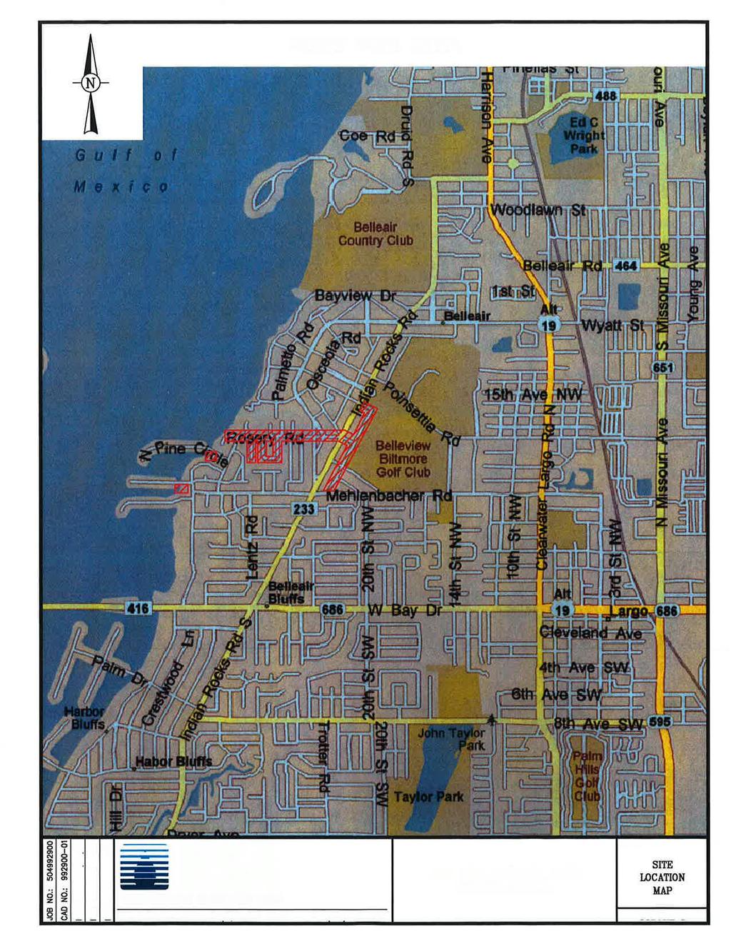
2 Atkins 4030 West Boy Scout Blvd., Suite 700 Tampa, Florida Via Electronic and Regular Mail Attention: Subject: Mr. Doug W. White Associate Project Manager Report of Pavement Coring and Town of Belleair Rosery Road Dear Mr. White: HSA Engineers & Scientists (HSA) is pleased to provide the results of our pavement coring and subsurface exploration to support the planned seawall, roadway and drainage improvements within the Town of Belleair in Pinellas County, Florida. This report briefly describes the testing performed, presents the profiles of the subsurface conditions encountered and provides an interpretation of the subsurface conditions with respect to the planned seawall and roadway improvements. The report also provides general pavement improvement recommendations. PROJECT INFORMATION The project consists of roadway and drainage improvements to about 7,465 lineal feet of existing roads, along with localized seawall improvements, within the Town of Belleair, in Pinellas County, Florida. We understand that the following roads and approximate lengths are part of this study: Rosery Road 2,700 feet Peaceful Avenue 650 feet Evonaire Circle 1,300 feet East Fowler Avenue / Tampa, Florida Tel: (813) / Fax: (813) Locations throughout the Southeastern United States
3 Report of Pavement Coring Page 2 Golf View Drive 2,200 feet Althea Road 315 feet Osceola Road 300 feet In addition, we understand that sections of the existing seawall at the west end of Rosery Road, and at the North Pine Circle and Winston Drive bridges are planned to be modified to accommodate new outfall structures/piping. The approximate limits of the study are shown on the attached Site Location Map (Figure 1). The roadway improvements may consist of standardizing road widths, asphalt milling and resurfacing, full-depth reconstruction, new curbs and/or gutters and drainage improvements as necessary. Existing pavement section data along with near surface soil and groundwater conditions were requested to assist in the development of the projects plans. PURPOSE AND SCOPE OF WORK The purpose of this study was to obtain information on shallow subsurface soil and groundwater conditions, and existing pavement section thickness of the subgrade, base and asphaltic concrete within the planned improvement areas. In addition, the subsurface conditions near three (3) planned seawall improvement projects, were explored. The following scope of work was completed for this evaluation: 1. Notified Sunshine State One Call of Florida, Inc. for utility locations; 2. Reviewed the Pinellas County Soil Survey pertaining to the shallow soils mapped within the project limits; 3. Obtained twenty eight (28) pavement cores to document the existing pavement material types and section thicknesses; 4. Performed twenty eight (28) hand auger borings in general accordance with ASTM D to depths of about 5 feet below existing grade at the pavement coring locations; 5. Performed five (5) Standard Penetration Test (SPT) borings in general accordance with ASTM D-1586 to depths of about 25 feet below existing grade at the seawall improvement locations. Six (6) SPT borings were originally planned; (two at each of the three locations) However, one boring was not performed at the Rosery Road seawall location due to the presence of excessive rip-rap on the water side of the seawall.) 6. Checked groundwater levels at each hand auger boring location; P:\Projects\50 Geotech\ Jobs\ Roadway Study Belleair - Rosery Rd (GEO)\Report\Belleair Rosery Road - Report.doc
4 Report of Pavement Coring Page 3 7. Collected soil samples for laboratory review and classification testing; 8. Performed a laboratory classification test program to further characterize representative soil types. The testing program consisted of moisture content, organic content and percent finer than No. 200 sieve; 9. Provided visual/manual soil classifications per ASTM D2487/2488 and soil profiles for the soil borings; 10. Presented the results of our subsurface exploration and testing in an engineering report, including: The data developed during the study including existing pavement type and thicknesses, soil profiles and laboratory test results. An interpretation of the soil stratigraphy based on our testing and the suitability of the subsurface conditions for the planned improvements. Backfill recommendations for seawall modifications. General pavement design recommendations, if necessary. Pavement underdrain recommendations. Seawall soil strength parameters. Seawall SPT Borings SUBSURFACE EXPLORATION A total of five (5) SPT borings were performed at the locations of the planned seawall improvements, as shown on the attached Boring Location Map (Figure 2). The borings were drilled to depths of about 25 feet below the top of the seawall cap. The SPT borings were performed in general accordance with ASTM D 1586 (Standard Test Method for Penetration Test and Split Barrel Sampling of Soils) using the rotary wash method, where a bentonite (clay) slurry ( drill mud or drill fluid ) was used to flush and stabilize the borehole. Following the advancement of a hand auger to a depth of 4 feet to check for possible unidentified buried utilities at the landside borings, Standard Penetration sampling was performed at closely spaced intervals throughout the drilling depth of 25 feet. After seating the sampler 6 inches into the bottom of the borehole, the number of blows required to drive the sampler one foot further with a standard 140 pound hammer dropped 30 inches is known as the N value or P:\Projects\50 Geotech\ Jobs\ Roadway Study Belleair - Rosery Rd (GEO)\Report\Belleair Rosery Road - Report.doc
5 Report of Pavement Coring Page 4 blowcount. The blowcount has been empirically correlated to soil properties. The recovered samples were placed into containers and returned to our office for visual review. Pavement Cores and Hand Auger Borings A series of twenty-eight (28) pavement cores with associated hand auger borings were performed at the locations shown on the attached Boring Location Map (Figure 2). The borings were advanced to nominal depths of 5 feet to check the shallow soil and groundwater conditions at the core locations. The hand auger borings were performed by manually rotating a bucket auger into the ground in approximately 4 to 6 inch increments. As each soil type was encountered, its depth interval was recorded and representative samples taken for review in the laboratory. The hand auger borings were conducted in general accordance with ASTM D 1452 (Standard Practice for Soil Investigation and Sampling by Auger Borings). LABORATORY TESTING Based on the visual inspection of the recovered samples, five (5) recovered soil samples were selected for laboratory testing. The laboratory tests included moisture content, organic content and a wash gradation. The laboratory testing was conducted in general conformance to ASTM standards and practices. Some procedural variations not considered material to the test data or to the conclusions reached herein may have been taken. The results of the moisture content, organic content and a wash gradation testing are included on the soil profiles illustrated on Figures 6 and 7. The moisture content is measured by weighing a sample of a selected material then drying it in a warm oven. Care is taken to use a gentle heat so as not to destroy any organic material. After heating, the sample is re-weighed. The difference of the two weights is the amount of moisture removed from the sample. The weight of the moisture divided by the weight of the dry soil sample is the percentage by weight of the moisture. The testing was performed in general accordance with ASTM D 2216 (Standard Test Method for the Determination of Water (Moisture) Content of Soil and Rock by Mass). The laboratory organic content test consists drying the soil sample, then heating it in a small furnace to a minimum temperature of 400 degrees Centigrade for 6 hours. The high heat burns off all organic material, leaving only the soil minerals. The difference in the weight prior to and after the burning is the weight of the organics. The weight of the organics divided by the weight of the dried soil is the percentage of the organics within a sample. Organic contents in excess of P:\Projects\50 Geotech\ Jobs\ Roadway Study Belleair - Rosery Rd (GEO)\Report\Belleair Rosery Road - Report.doc
6 Report of Pavement Coring Page 5 about 5 percent are generally considered detrimental. This testing was conducted in general accordance with ASTM D-2974 (Standard Test Methods for Moisture, Ash and Organic Matter of Peat and Other Organic Soils). The wash gradation test measures the percentage of a dry soil sample passing the No. 200 sieve. By definition, the percentage by weight passing the No. 200 sieve is the silt and clay content. This test was performed in general accordance with ASTM D 1140 (Standard Test Methods for Amount of Material Finer than the No. 200 (75 µm) Sieve). Soil Conservation Service Data SUBSURFACE CONDITIONS The U.S. Department of Agriculture Natural Resources Conservation Service, formerly known as the Soil Conservation Service (SCS), has mapped the shallow soils in this area of Pinellas County. This information was archived in an electronic database (Web Soil Survey: URL At the planned seawall improvement sites, the soil survey describes the soils as Matlacha and St. Augustine soils and Urban Land (mapping unit 16). For the majority of the pavement improvement areas, the soil survey describes the soils as Myakka soils and Urban land, (mapping unit 17). For the section of Rosery Road, generally between Peaceful Avenue and Meredith Lane, including most of Evonaire Circle, the soil survey indentifies Astatula soils and Urban land, (mapping unit 4). Finally, for the southern portion of Golf View Drive, the soils are described as Tavares soils and Urban land, (mapping unit 29). Matlacha soil is derived from dredge and fill operations. The typical profile of Matlacha soil is as follows: Depth Soil Description 0 to 42 inches Mixed very dark gray, light brownish gray, and very pale brown sand that has 20 percent, by volume, shell fragments and limestone fragments 42 to 51 inches Gray fine sand that has 5 percent, by volume, shell fragments 51 to 80 inches Light gray fine sand that has 30 percent, by volume, shell fragments P:\Projects\50 Geotech\ Jobs\ Roadway Study Belleair - Rosery Rd (GEO)\Report\Belleair Rosery Road - Report.doc
7 Report of Pavement Coring Page 6 St. Augustine soils are also derived from dredge and fill operations. The typical profile of St. Augustine Soil is as follows: Depth Soil Description 0 to 8 inches Dark gray sand that has 10 percent, by volume shell fragments 8 to 22 inches Light gray fine sand 22 to 33 inches Brown loamy fine sand that has yellowish brown and reddish yellow mottles and 12 percent, by volume, shell fragments 33 to 48 inches Light gray fine sand that has 10 percent, by volume, shell fragments 48 to 63 inches Mixed gray and light brownish gray sandy loam that has yellowish brown mottles and 5 percent, by volume, shell fragments 63 to 80 inches Light gray sand that has 40 percent, by volume, shell fragments Urban land consists of high-density residential developments, commercial buildings, streets, highways, parking lots, and other types of impervious ground cover. The areas of Matlacha and St. Augustine soils that are not covered by impervious material are too small to be delineated separately at the scale of mapping and are mostly grassy areas. Myakka fine sand is nearly level and poorly drained. In its natural state, it is located on broad, low ridges between swamps and sloughs in pine flatwoods and in small areas on the upland ridge. Typically, this soil has a surface layer of black fine sand to a depth of about 4 inches, which is followed by gray fine sand. From depths of 16 to 20 inches, black fine sand is usually indicated, which grades to dark reddish brown fine sand below 20 inches. Dark yellowish brown fine sand occurs from 25 to 30 inches deep, and is in turn underlain by light yellowish brown fine sand. Very pale brown fine sand is then found to a depth of 80 inches or more. Astatula soil in its unaltered state has a surface layer of dark gray fine sand about 5 inches thick. The underlying soil to a depth of about 18 inches is yellowish brown fine sand. The yellowish brown fine sand grades to yellow. A different shade of yellow occurs below 70 inches, and continues to in excess of 80 inches. The typical profile of Tavares soils, which may have been altered by development activities in this mapping unit is as follows: Depth Soil Description 0 to 5 inches Very dark grayish brown fine sand 5 to 25 inches Very pale brown fine sand 25 to 50 inches Light yellowish brown fine sand 50 to 65 inches Very pale brown fine sand with yellowish red mottles 65 to 80+ inches Very pale brown fine sand with yellowish red and reddish brown mottles P:\Projects\50 Geotech\ Jobs\ Roadway Study Belleair - Rosery Rd (GEO)\Report\Belleair Rosery Road - Report.doc
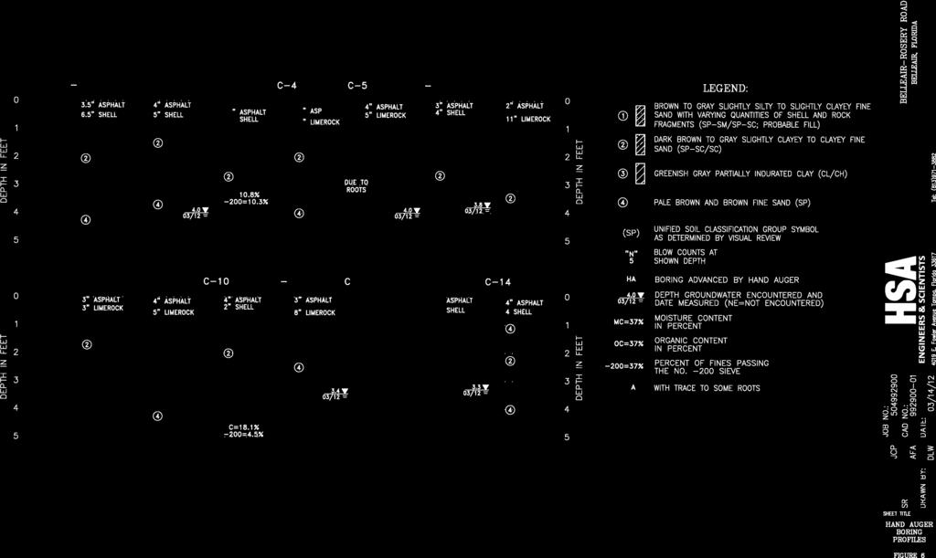
8 Report of Pavement Coring Page 7 The USDA Soil Survey is not necessarily an exact representation of the soils on the site. The mapping is based on interpretation of aerial maps with scattered shallow borings for confirmation. The transition between different soil types may be gradual and the indicated boundary approximate. Differences may also occur from the typical stratigraphy and small areas of other similar and dissimilar soils may occur within the mapping unit. As such, there may be differences in the mapped description and the boring descriptions obtained for this report. The survey is, however, a good basis for evaluating the shallow soil conditions of the area. Seawall SPT Boring Results The SPT borings performed at the three seawall improvement areas encountered relatively uniform subsurface conditions. The upper 2 to 4 feet of the borings performed behind the seawalls generally encountered fill materials consisting of relatively loose, brown to gray fine sands with variable silt and clay fines and varying quantities of shell and rock fragments (Stratum 1). Below the fill materials, the borings penetrated a relatively thin layer of very loose to loose, dark brown to gray slightly clayey to clayey fine sand (Stratum 2). Below a depth of about 4 to 6 feet in all of the SPT borings, stiff to hard greenish gray, partially indurated clay was encountered to the boring termination depths of about 25 feet. The table below presents our estimated values for the various soil strata encountered. Soil Strata RECOMMENDED ESTIMATED SOIL PARAMETERS USCS Soil Group Saturated Unit Weight Friction Angle Cohesion Value Active Earth Pressure Value Ka Passive Earth Pressure Value Kp 1 (SP-SM/SP-SC) pcf 32 deg 0 psf (SC) pcf 33 deg 0 psf (CL/CH) pcf 0 deg 5,000 psf Specific details for each soil profile, along with the laboratory test results are presented on the attached cross-sections, (Figures 3 5). Pavement Core and Hand Auger Boring Results Pavement core thicknesses, base type and thickness, and soil profiles of the hand auger borings for this study are illustrated on Figures 6 and 7. The stratification information was developed from the field logs, laboratory testing results and visual review/manual classification of the P:\Projects\50 Geotech\ Jobs\ Roadway Study Belleair - Rosery Rd (GEO)\Report\Belleair Rosery Road - Report.doc
9 Report of Pavement Coring Page 8 recovered soil samples in general accordance with ASTM D2487/2488. The stratification lines represent the boundary between soil types at the test locations. The transition between strata may be gradual and the boundary approximate. Soil strata boundaries were estimated when they occurred between sample intervals. Small variations not considered important to our engineering evaluation may have been omitted or abbreviated for clarity. The test boring logs include groundwater depths (where encountered) and laboratory testing results. Following are the generalized subsurface conditions encountered in the borings performed for this study. Please refer to the soil boring logs for more detailed information. Pavement Cores In general, the asphaltic concrete thicknesses varied between around 2 and 4 inches. At three (3) of the locations (C-25, C-26 and C-27 Evonaire Circle) the asphaltic concrete thickness was recorded at about 1 inch, and at location C-18 (Golf View Drive), the asphaltic concrete was about 5 inches in thickness. The base course, which consisted of either shell or limerock, was measured to be between around 2 inches and 11 inches thick. The soils encountered below the base course did not appear to be stabilized. Hand Auger Borings Beneath the existing pavement sections, the borings generally encountered two (2) strata. Stratum 2 consisted of dark brown to gray slightly clayey to clayey fine sand and was encountered in the upper portions of most all of the borings. Stratum 4 consisted of pale brown and brown fine sand and was generally encountered in the lower portions of most all of the borings. A few of the borings encountered the Stratum 1 probable fill materials in the upper 1 to 2 feet. Also, boring C-5 was terminated at a depth of about 2-1/2 feet, due to the presence of roots. Trace amounts of roots were also encountered in boring C-27. Laboratory testing performed on four (4) samples of the Stratum 2 soils resulted in moisture contents ranging from 10.8% to 25.4%, percent fines ranging from 5.9% to 16.4%, and organic contents ranging from 1.4% to 3.3%. Laboratory tests performed on one (1) sample of the Stratum 4 soils resulted in a moisture content of 18.1% and a percent fines content of 4.5%. Groundwater Information The phreatic surface of the surficial aquifer was detected at most of the hand auger boring locations. Where encountered, the depth to the groundwater varied from about 3 feet to 4 feet below the existing roadway surface. One exception was at boring C-27 on Evonaire Circle, where the groundwater was encountered around 1.6 feet below existing grade. A homeowner near this location mentioned to our field crew that a French Drain existed in the area. No additional information was provided. Other than boring C-27, the borings performed in and around Peaceful Avenue and Evonaire Circle did not encounter groundwater in the 5 feet explored. P:\Projects\50 Geotech\ Jobs\ Roadway Study Belleair - Rosery Rd (GEO)\Report\Belleair Rosery Road - Report.doc
10 Report of Pavement Coring Page 9 It should be noted that groundwater levels tend to fluctuate during periods of prolonged drought and extended rainfall and may also be affected by tidal influences. A seasonal effect will occur such that groundwater level fluctuations can be expected between the dryer winter and spring months as compared to the summer months or the wet season. Based on the topography of the project area, (higher elevations to the east, sloping downward toward the Intracoastal Waterway to the west), the groundwater flow should be expected to follow the topography toward the west and toward the Intracoastal Waterway. Seasonal High Groundwater Estimates The majority of the hand auger borings penetrated fill/reworked soils with a variable depth to the groundwater table. The table below lists the anticipated depth to the seasonal high groundwater levels at each of the boring locations based on the groundwater levels measured, existing site conditions, soil conditions encountered and SCS reported values. Heavy or prolonged rainfall could result in groundwater levels being temporarily higher than the normal seasonal high groundwater estimates. Town of Belleair Pavements - Estimated Seasonal High Groundwater Depths Location Boring Depth (ft) Groundwater Depth (ft) Estimated Seasonal High Groundwater Depth (ft) C C C C-4 5 N.E. 3 C N.E. 3 C C C C C C C C C C C C C C C P:\Projects\50 Geotech\ Jobs\ Roadway Study Belleair - Rosery Rd (GEO)\Report\Belleair Rosery Road - Report.doc
11 Report of Pavement Coring Page 10 C C C-23 5 N.E. 4 C-24 5 N.E. 4 C-25 5 N.E. 4 C-26 5 N.E. 4 C C N.E.-Not encountered to the boring termination depth. GENERAL PAVEMENT DESIGN GUIDELINES These pavement design guidelines are made without the benefit of specific traffic information, local constraints or grading plans, and are intended as a general guide for the design engineer s evaluation. Site design decisions may obviate certain aspects of these guidelines. The existing pavement subgrade soils appear to consist primarily of fine sands. In general, the near surface soils encountered along the project alignments should be acceptable for construction and support of a flexible (limerock, crushed concrete, or shell base) type pavement sections after nominal subgrade preparation and drainage improvements. Underdrains: Based on the soil conditions encountered and the groundwater levels recorded, it does not appear that underdrains are warranted for the planned roadway improvements. Flexible Pavement: We anticipate that a flexible pavement will be employed for this project. The roadways appeared to be in a fairly satisfactory condition and simply warrant a milling and resurfacing approach. However, for any full depth pavement replacement areas, the choice of pavement base type will depend on final pavement grades as well as economic conditions. At a minimum, the base thickness should be no less than 6 inches in light automobile traffic areas and 8 inches in the more frequent traffic areas. The base should be compacted to a density of no less than 98% of the modified Proctor value. If a minimum separation of 24 inches between the bottom of the base and the seasonal high groundwater level is maintained, then a limerock or shell base can be utilized. Limerock and shell base material should meet Florida Department of Transportation (FDOT) requirements and a minimum LBR of 100. P:\Projects\50 Geotech\ Jobs\ Roadway Study Belleair - Rosery Rd (GEO)\Report\Belleair Rosery Road - Report.doc
12 Report of Pavement Coring Page 11 A soil cement or processed concrete aggregate base could be utilized if the separation between bottom of the base material and the seasonal high groundwater level is a minimum of 12 inches. Crushed concrete should also have a minimum LBR value of 100 and be graded in accordance with FDOT Standard Specification Section 204. A soil cement base, if selected, should be designed according to FDOT short cut design procedures. A minimum 7-day compressive strength of 300 pounds per square inch (psi) should be achieved on laboratory cured specimens. The flexible pavement surface course should consist of at least 1-1/2 inches of FDOT Type SP 9.5 asphaltic concrete material for the light automobile traffic areas and 2 inches for more frequent traffic areas. The asphaltic concrete should meet standard FDOT material requirements and placement procedures as outlined in the current FDOT Standard Specifications for Road and Bridge Construction, except that the asphaltic concrete should be compacted to a minimum of 96% of the Marshall maximum laboratory unit weight of samples secured daily during placement. LIMITATIONS Our professional services have been performed, our findings obtained and our opinions prepared in accordance with generally accepted geotechnical engineering principles and practices. HSA is not responsible for the conclusions, opinions or recommendations made by others based on these data. The scope of this study was intended to evaluate generalized pavement and subsurface conditions along the project limits. The analysis and opinions submitted in this report are based upon the data obtained from the soil borings performed at the locations indicated. If any subsurface variations become evident, a re-evaluation of the opinions contained in this report will be necessary after we have had an opportunity to observe the characteristics of the conditions encountered. The scope of our services does not include any environmental assessment or investigation for the presence or absence of wetlands, hazardous or toxic materials in the soil, groundwater, or surface water within or beyond the site studied. Any statements in this report regarding odors, staining of soils, or other unusual conditions observed are strictly for the information of our client. P:\Projects\50 Geotech\ Jobs\ Roadway Study Belleair - Rosery Rd (GEO)\Report\Belleair Rosery Road - Report.doc
13 Report of Pavement Coring Page 12 CLOSURE HSA Engineers & Scientists appreciates the opportunity to be of service to you on this project. We look forward to working with you during construction as your materials testing laboratory. Should you have any questions or require additional information, please do not hesitate to contact us at your convenience. Sincerely, HSA Engineers & Scientists John C. Phillips, P.E. Andres F. Alberdi, P.E. Senior Geotechnical Engineer Senior Geotechnical Engineer Florida License No Florida License No Figures 1-7 P:\Projects\50 Geotech\ Jobs\ Roadway Study Belleair - Rosery Rd (GEO)\Report\Belleair Rosery Road - Report.doc

14

15

16
17
18
19
20
21 June 12, 2012 Atkins 4030 West Boy Scout Blvd., Suite 700 Tampa, Florida Via Electronic and Regular Mail Attention: Subject: Mr. Doug W. White Associate Project Manager Addendum to Report of Pavement Coring and Town of Belleair Rosery Road Dear Mr. White: HSA Engineers & Scientists (HSA) is pleased to provide this addendum to our previous report, dated. The purpose of this addendum is to provide recommendations for pavement underdrain areas and full depth pavement section replacement areas. Underdrains: Based on the groundwater level recorded at location C-27, underdrains should be considered along the east portion of Evonaire Circle. Flexible Pavement: Based on our observations of the existing roadway surface conditions, it would appear that the following roads may warrant a full depth replacement: South and east portions of Evonaire Circle Harborside Drive, west of Eagles Nest Drive These roads are currently exhibiting excessive wear and pavement surface failures that may be related to base failures and/or groundwater flow conditions. The remaining roadways appeared to be in a fairly satisfactory condition and simply warrant a milling and resurfacing approach East Fowler Avenue / Tampa, Florida Tel: (813) / Fax: (813) Locations throughout the Southeastern United States

22 Addendum to Report of Pavement Coring June 12, 2012 Page 2 For the full depth replacement areas, the choice of pavement base type will depend on final pavement grades as well as economic conditions. At a minimum, the base thickness should be no less than 6 inches in light automobile traffic areas and 8 inches in the more frequent traffic areas. The base should be compacted to a density of no less than 98% of the modified Proctor value. If a minimum separation of 24 inches between the bottom of the base and the seasonal high groundwater level is maintained, then a limerock or shell base can be utilized. Limerock and shell base material should meet Florida Department of Transportation (FDOT) requirements and a minimum LBR of 100. A soil cement or processed concrete aggregate base could be utilized if the separation between bottom of the base material and the seasonal high groundwater level is a minimum of 12 inches. Crushed concrete should also have a minimum LBR value of 100 and be graded in accordance with FDOT Standard Specification Section 204. A soil cement base, if selected, should be designed according to FDOT short cut design procedures. A minimum 7-day compressive strength of 300 pounds per square inch (psi) should be achieved on laboratory cured specimens. The flexible pavement surface course should consist of at least 1-1/2 inches of FDOT Type S asphaltic concrete material (SI or SIII) for the light automobile traffic areas and 2 inches for more frequent traffic areas. The asphaltic concrete should meet standard FDOT material requirements and placement procedures as outlined in the current FDOT Standard Specifications for Road and Bridge Construction, except that the asphaltic concrete should be compacted to a minimum of 96% of the Marshall maximum laboratory unit weight of samples secured daily during placement. Should you have any questions or require additional information, please do not hesitate to contact us at your convenience. Sincerely, HSA Engineers & Scientists John C. Phillips, P.E. Senior Geotechnical Engineer Florida License No P:\Projects\50 Geotech\ Jobs\ Roadway Study Belleair - Rosery Rd (GEO)\Report\Belleair Rosery Road - Addendum to Report.doc
REPORT OF GEOTECHNICAL EXPLORATION WEST MARJORY AVENUE TAMPA, FLORIDA
 REPORT OF GEOTECHNICAL EXPLORATION WEST MARJORY AVENUE TAMPA, FLORIDA AREHNA PROJECT NO. B-15-008 March 11, 2015 Prepared For: City of Tampa Stormwater Division 306 W. Jackson Street, 6N Tampa, Florida
August 15, 2006 (Revised) July 3, 2006 Project No A
 July 3, 2006 Project No A") August 15, 2006 (Revised) July 3, 2006 Project No. 01-05-0854-101A Mr. David Reed, P.E. Protean Design Group 100 East Pine Street, Suite 306 Orlando, Florida 32801 Preliminary Soil Survey Report Polk Parkway
August 15, 2006 (Revised) July 3, 2006 Project No. 01-05-0854-101A Mr. David Reed, P.E. Protean Design Group 100 East Pine Street, Suite 306 Orlando, Florida 32801 Preliminary Soil Survey Report Polk Parkway
Report of Subsurface Exploration and Geotechnical Evaluation Services
 Final Report of Subsurface Exploration and Geotechnical Evaluation Services Noho 2 Apartments Multi-Family Development Tampa, Florida Prepared for: Pollack Shores Real Estate Group Conestoga-Rovers & Associates
PROPOSED CONDOS 1129 Victoria Drive, Dunedin Parcel: , Pinellas County Geotechnical Services June Report No.
 Central Florida Testing Laboratories, Inc. Testing, Development and Research 12625-40th Street North Clearwater, Florida 33762 ENGINEERING BUSINESS NO. 1066 GEOLOGY BUSINESS NO. 224 TAMPA BAY AREA (727)
This report presents the findings of the subsurface exploration concerning the design of the taxiway rehabilitation. Description
 September 22, 2016 American Infrastructure Development, Inc. 3810 Northdale Boulevard, Suite 170 Tampa, Florida 33624 Attn: Mr. Mohsen Mohammadi, Ph.D., P.E. Senior Consultant Mob: (813) 244-6609 E-mail:
Geotechnical Exploration and Evaluation Report
 Geotechnical Exploration and Evaluation Report Nassau Reclaimed Water Main From Radio Avenue to Harts Road Nassau County, Florida CSI Geo Project No.: 71-17-329-04 Client Project No.: JEA 09302-049-01
ORLANDO SANFORD INTERNATIONAL AIRPORT OUTPARCEL 1 SANFORD, FLORIDA
 PRELIMINARY GEOTECHNICAL STUDY ORLANDO SANFORD INTERNATIONAL AIRPORT OUTPARCEL 1 SANFORD, FLORIDA November 9, 2015 Prepared For: Ms. Diane H. Crews, A.A.E. Sanford Airport Authority 1200 Red Cleveland
April 7, Webster Street Sub-Surface Stormwater Storage System Bid No Bid Date: 4/13/17 ADDENDUM NO 1
 PUBLIC WORKS DEPARTMENT David A. Jones, P.E., Director April 7, 2017 Webster Street Sub-Surface Stormwater Storage System Bid No. 2017-022 Bid Date: 4/13/17 ADDENDUM NO 1 Please make the following changes
CONDUCTED FOR: PREPARED FOR: 18 October 2010 YPC Project No. 10GY133
 GEOTECHNICAL EXPLORATION AND ENGINEERING SERVICES REPORT CONDUCTED FOR: Immokalee Stormwater Master Plan Implementation Immokalee, Collier County, Florida PREPARED FOR: Mr. Marc Stonehouse, P. E. Project
ORLANDO SANFORD INTERNATIONAL AIRPORT OUTPARCEL 6 SANFORD, FLORIDA
 PRELIMINARY GEOTECHNICAL STUDY ORLANDO SANFORD INTERNATIONAL AIRPORT OUTPARCEL 6 SANFORD, FLORIDA November 9, 2015 Prepared For: Ms. Diane H. Crews, A.A.E. Sanford Airport Authority 1200 Red Cleveland
Geotechnical Investigation Report
 MC Squared, Inc Geotechnical Investigation Report S. Edison Avenue Roadway Improvements City Of Tampa Florida Prepared for: Ms. Barbara Graves City of Tampa DPW Stormwater Engineering 306 E. Jackson St.,6N
Ardaman & Associates, Inc. Geotechnical, Environmental and Materials Consultants
 SUBSURFACE SOIL EXPLORATION ANALYSIS AND RECOMMENDATIONS PROPOSED WEIRS AT STATIONS 130+00 AND 16+00 DRAINAGE IMPROVEMENTS TO THE FOUR CORNERS MSBU HENDRY COUNTY, FLORIDA Ardaman & Associates, Inc. Geotechnical,
mtec REPORT OF GEOTECHNICAL EXPLORATION FTFA Construct Bin Wall at HERD Eglin AFB, Florida
 mtec REPORT OF GEOTECHNICAL EXPLORATION FTFA 14-3001 - Construct Bin Wall at HERD Eglin AFB, Florida MTEC Project Number 2014-101 November 10, 2014 Revised: January 5, 2015 Prepared For: Peterson Engineering,
REPORT OF GEOTECHNICAL EXPLORATION AND ENGINEERING ANALYSIS
 FIGURE 3 Geotechnical Report (2) REPORT OF GEOTECHNICAL EXPLORATION AND ENGINEERING ANALYSIS RIVER TOWER RESTORATION RIVER TOWER PARK TAMPA, FLORIDA AREHNA PROJECT NO. B-13-002 February 22, 2013 Prepared
Preliminary Soil Survey Report
 Florida Department of TRANSPORTATION Preliminary Soil Survey Report Malabar Road (SR 514) PD&E Study From East of Babcock Street (SR 507) to US 1 Brevard County, Florida FPID: 430136 1 22 01 ETDM: 13026
Sepetember 27, Florida Department of Environmental Protection Attn: Dawn Templin 160 Governmental Center Pensacola, FL
 Bay County Solid Waste 11411 Landfill Rd. Panama City Beach, Florida 32413 Telephone: (850) 236-2212 Fax: (850) 233-5053 Board of County Commissioners www.baycountyfl.gov Sepetember 27, 2018 Florida Department
ADDENDUM NO. 1. PROJECT NAME: Bostic Pelt Road NRCS Drainage Improvements PRI PROJECT NO: Wakulla Co ITB#
 ADDENDUM NO. 1 DATE: January 22, 214 TO: Prospective Bidders via individual e-mails FROM: Alan Wise, P.E. PROJECT NAME: Bostic Pelt Road NRCS Drainage Improvements PRI PROJECT NO: 23.15 ---- Wakulla Co
SUMMARY REPORT OF A GEOTECHNICAL SITE EXPLORATION LACROSSE CITRUS REPOSITORY LACROSSE, ALACHUA COUNTY, FLORIDA. GSE PROJECT No.
 SUMMARY REPORT OF A GEOTECHNICAL SITE EXPLORATION LACROSSE CITRUS REPOSITORY LACROSSE, ALACHUA COUNTY, FLORIDA GSE PROJECT No. 1128 Prepared For: BURE OF CITRUS BUDWOOD REGISTRATION SEPTEMBER 2011 Certificate
For. Report of Geotechnical Exploration. University of North Florida Parking Lot 11 Jacksonville, Florida
 Report of Geotechnical Exploration For University of North Florida Parking Lot 11 Jacksonville, Florida MAE Project No. 0019-0008 January 13, 2017 Prepared for: GAI Consultants 1301 Riverplace Boulevard,
Geotechnical Exploration and Evaluation Report
 Geotechnical Exploration and Evaluation Report Pavement Coring and Evaluation UNF Parking Lot 3 Jacksonville, Florida CSI Geo Project No.: 71-18-135-23 Prepared by CSI Geo, Inc. 2394 St. Johns Bluff Road
Applied GeoScience, Inc Hammond Dr., Suite 6 Schaumburg, Illinois
 AGI Project No. 13-276 Subsurface Investigation Report For the Proposed New Retail Center 9601 South Pulaski Road Evergreen Park, Illinois Prepared for Mr. Feras Sweis FHS Design + Build LLC 2010 West
 Appendix A - Vicinity Map Vicinity Map: Palm Beach Gardens City Hall Additions, 000 N Military Trail, Palm Beach Gardens, FL Proposed Location of Police Dept. Attached Addition Proposed Location of New
Subsurface Investigation Report. Proposed New 1-Story Building 6447 Grand Avenue Gurnee, Illinois
 AGI Project No. -11 Subsurface Investigation Report For the Proposed New 1-Story Building 6447 Grand Avenue Gurnee, Illinois Prepared for Mr. Steve Panko Key Development Partners, LLC North State Street,
REPORT OF GEOTECHNICAL CONSULTING SERVICES
 REPORT OF GEOTECHNICAL CONSULTING SERVICES Escambia County Public Works Department Thompson, Crary and McNeal Roadway Project Escambia County, Century,FL Thompson Engineering Project No.: 15-1101-0297
100% Report of Geotechnical Engineering Investigation CENTRAL FLORIDA COMMUTER RAIL TRANSIT SUNRAIL PHASE 2 SOUTH Poinciana Vehicle Storage & Light
 100% Report of Geotechnical Engineering Investigation CENTRAL FLORIDA COMMUTER RAIL TRANSIT SUNRAIL PHASE 2 SOUTH Poinciana Vehicle Storage & Light Maintenance Facility (VSLMF) Osceola County, Florida
Ardaman & Associates, Inc. Geotechnical, Environmental and Materials Consultants
 SUBSURFACE SOIL EXPLORATION ANALYSIS AND RECOMMENDATIONS CREEKSIDE BOULEVARD FORCE MAIN EXTENSION AND INTERCONNECT NAPLES, COLLIER COUNTY, FLORIDA COLLIER COUNTY PROJECT NO. 700.2. P.O. #0003, CN #3-66
Report of Exploratory Test Pits
 Report of Exploratory Test Pits UNF Transportation Projects Stockpile Investigation Osprey Ridge Road Extension Jacksonville, Florida CSI Geo Project No.: 71-17-135-20 Arcadis Project No.: JK017002.0001
Geotechnical Engineering Report
 BIG CYPRESS SEMINOLE INDIAN RESERVATION WATER TREATMENT FACILITY October 29, 2015 Terracon Project No. HD155065 Prepared for: REISS ENGINEERING, INC. 1016 Spring Villas Pt. Winter Springs, FL 32708 Prepared
Report of Geotechnical Exploration For. University of North Florida Kernan Shuttle Stop Jacksonville, Florida
 Report of Geotechnical Exploration For University of North Florida Kernan Shuttle Stop Jacksonville, Florida MAE Project No. 0016-0023 March 18, 2015 Prepared for: Prepared by: Jacksonville, Florida 32256
CONDUCTED FOR: PREPARED FOR: 5 May 2016 YPC Project No. 16GY146
 GEOTECHNICAL EXPLORATION SERVICES REPORT CONDUCTED FOR: Collier Boulevard PREPARED FOR: Mr. Christopher L. Johnson Director of Land Development Stock Development, LLC Professional Circle, Suite 01 Naples,
Geotechnical Engineering Report
 Geotechnical Engineering Report Pavement Subgrade Survey State Highway 125 over Hudson Creek Ottawa County, Oklahoma September 23, 21 Terracon Project No. 415121 Prepared for: Guy Engineering Services,
REPORT OF GEOTECHNICAL EXPLORATION GLYNN COUNTY DETENTION CENTER GLYNN COUNTY, GEORGIA E&A PROJECT NO
 REPORT OF GEOTECHNICAL EXPLORATION GLYNN COUNTY DETENTION CENTER GLYNN COUNTY, GEORGIA E&A PROJECT NO. - Prepared for: IPG Architects, Inc. Northwood Park Drive Valdosta, Georgia Prepared by: Ellis & Associates,
Civil Geotechnical Surveying
 Civil Geotechnical Surveying Mr. David Burnett Cabarrus County Schools 4425 Old Airport Road Charlotte, North Carolina 28025 May 16, 2017 Reference: Geotechnical Engineering Evaluation Future PLC Site
REPORT OF GEOTECHNICAL EXPLORATION PEPSI PLACE WATER MAIN REPLACEMENT JACKSONVILLE, FLORIDA E&A PROJECT NO CLIENT ID: 4784
 REPORT OF GEOTECHNICAL EXPLORATION PEPSI PLACE WATER MAIN REPLACEMENT JACKSONVILLE, FLORIDA E&A PROJECT NO. 35-55 CLIENT ID: 78 Prepared for: Construction & Engineering Services Consultants, Inc. 93 Baymeadows
Please include this addendum in your Bid proposal for the above referenced project. Questions are in black ink, and the answers are in red ink.
 JAHarchitects, LLC PROJECT NO. 393 RIVERCREST CDD 11560 RAMBLE CREEK DRIVE, RIVERVIEW FL ADDENDUM TO BID PROJECT: RIVERCREST CDD MULTI PURPOSE FIELD MAINTENANCE BUILDING & DOG PARK POOL & CABANNA JAH PROJECT
DEPARTMENT OF TRANSPORTATION DIVISION: MATERIALS REPORT COVER SHEET. Revised Soil Survey Report November 24, 2015 Matthew G. Moore, P.E.
 LD-0 /12/09 DEPARTMENT OF TRANSPORTATION DIVISION: MATERIALS REPORT COVER SHEET Revised Soil Survey Report November 2, 201 Matthew G. Moore, P.E. VDOT (Division) or Company Name Insert Location, Virginia
PART 2D. Section 7.2 of SJRWMD Special Publication SJ93-SP10
 PART 2D GEOTECHNICAL INVESTIGATION TO ESTIMATE AQUIFER PARAMETERS Note the word is estimate & not determine. Must appreciate the physical meaning of each aquifer parameter. Aquifer, in this sense, does
October 11, 2011 Re-Issued November 15, 2011
 Shadow Wood Investors LLC 425 W New England Avenue, Suite 425 Winter Park, FL 32789 October 11, 2011 Re-Issued November 15, 2011 LOCATIONS: Atlanta Daytona Beach Fort Myers Fort Pierce Gainesville Jacksonville
Report of Preliminary Geotechnical Engineering Investigation for Ponds
 Report of Preliminary Geotechnical Engineering Investigation for Ponds Segment 3: State Road 400 (SR 400)/Interstate 4 (I-4) from One Mile East of SR 434 to East of SR 15-600/US 17-92 Seminole County (77160),
Report of Geotechnical Exploration For Baymeadows Road/Old Still PUD 6 inch Reclaimed Water Main Jacksonville, FL
 Report of Geotechnical Exploration For Baymeadows Road/Old Still PUD inch Reclaimed Water Main Jacksonville, FL MAE Project No. 0 000 June, 0 Prepared for: CPH, Inc. 00 Belfort Road, Suite 0 Jacksonville,
GEOTECHNICAL INVESTIGATION PROPOSED OUTFALL LOCATION CITY OF MORGAN S POINT DRAINAGE HARRIS COUNTY, TEXAS REPORT NO
 GEOTECHNICAL INVESTIGATION PROPOSED OUTFALL LOCATION CITY OF MORGAN S POINT DRAINAGE HARRIS COUNTY, TEXAS REPORT NO. 1140198001 Reported to: SIRRUS ENGINEERS, INC. Houston, Texas Submitted by: GEOTEST
PART 1b. Section 7.2 of SJRWMD Special Publication SJ93-SP10
 PART 1b GEOTECHNICAL INVESTIGATION TO ESTIMATE AQUIFER PARAMETERS Note the word is estimate & not determine. Must appreciate the physical meaning of each aquifer parameter. Aquifer, in this sense, does
APPENDIX A DRAINAGE STUDY PHASE 2 ALTERNATIVE IMPROVEMENTS CRYSTAL LAKE ALTERNATIVE 4C IMPROVEMENTS LAKEWOOD PIRATELAND SWASH HORRY COUNTY, SC
 DRAINAGE STUDY PHASE ALTERNATIVE IMPROVEMENTS CRYSTAL LAKE ALTERNATIVE C IMPROVEMENTS ` FOR: LAKEWOOD PIRATELAND SWASH HORRY COUNTY, SC APPENDIX A J-.000 Prepared by: Savannah, GA Charleston, SC Myrtle
May 2, Mr. Tim Kurmaskie, AIA ARCHITECT KURMASKIE ASSOCIATES, INC Washington Street Raleigh, NC
 Mr. Tim Kurmaskie, AIA ARCHITECT KURMASKIE ASSOCIATES, INC. 1030 Washington Street Raleigh, NC 27605-1258 May 2, 2017 Re: Report of Subsurface Investigation Westfield Rehabilitation & Health Care Additions
For. Report of Geotechnical Exploration. University of North Florida Parking Lot 47 Jacksonville, Florida
 Report of Geotechnical Exploration For University of North Florida Parking Lot 47 Jacksonville, Florida MAE Project No. 0019-0009 April 5, 2017 Revised: April 6, 2017 Prepared for: Prepared by: Jacksonville,
REPORT OF GEOTECHNICAL EXPLORATION BYFORGE ENGINEERING FOR REFERENCE ONLY
 REPORT OF GEOTECHNICAL EXPLORATION BYFORGE ENGINEERING FOR REFERENCE ONLY HERITAGE BAY MASTER PUMP STATION ISSUED FOR BID REPORT OF GEOTECHNICAL EXPLORATION PROPOSED INLINE WASTEWATER BOOSTER STATION Collier
May 1, THE CORRADINO GROUP 4055 N.W. 97 th Avenue Miami, Florida Mr. Carlos E. Verson, P.E. Project Manager
 May 1, 213 THE CORRADINO GROUP 455 N.W. 97 th Avenue Miami, Florida 33178 Attention: Mr. Carlos E. Verson, P.E. Project Manager Re: Report of Geotechnical Engineering Services - Roadway Soil Survey Bird
This Page Intentionally Left Blank
 GEOTECHNICAL REPORT This Page Intentionally Left Blank July 30, 2014-Revised December 11, 2013 South Florida Water Management District 3301 Gun Club Road West Palm Beach, Florida 33406 Attn: Mr. Jesse
EEI PROJECT NUMBER 5891G-NC PREPARED FOR: HILCO LTD 1435 US HIGHWAY 285 N KINSTON, NC SUBMITTED BY: MATTHEW C. KIRCHNER, E.I.
 SUMMARY REPORT OF GEOTECHNICAL SUBSURFACE EXPLORATION AND ENGINEERING EVALUATION PROPOSED PINEY GROVE NURSING & REHABILIATION CENTER EXPANSION 728 PINEY GROVE RD KERNERSVILLE, NORTH CAROLINA EEI PROJECT
Geotechnical Investigation Report
 MC Squared, Inc. Geotechnical Investigation Report City of St. Petersburg Forcemain Pinellas County, Florida Prepared for: Hazen and Sawyer 10002. Princess Palm Ave., Suite 200 Tampa, Florida 33610 Prepared
GEOTECHNICAL INVESTIGATION & ASSESSMENT TO ESTIMATE AQUIFER PARAMETERS
 GEOTECHNICAL INVESTIGATION & ASSESSMENT TO ESTIMATE AQUIFER PARAMETERS SJRWMD PONDS WORKSHOP! Note the word is estimate & not determine! Must appreciate the physical meaning of each aquifer parameter!
Report of Preliminary Geotechnical Engineering Investigation for Ponds
 Report of Preliminary Geotechnical Engineering Investigation for Ponds Segment 2: State Road 400 (SR 400)/Interstate 4 (I-4) from West of SR 528 (Beachline Expressway) to West of SR 435 (Kirkman Road)
GEOTECHNICAL STUDY PROPOSED CONCRETE ROADWAY TIKI ISLAND COMMUNITY GALVESTON COUNTY, TEXAS PROJECT NO E
 GEOTECHNICAL STUDY PROPOSED CONCRETE ROADWAY TIKI ISLAND COMMUNITY GALVESTON COUNTY, TEXAS PROJECT NO. 15-945E TO VILLAGE OF TIKI ISLAND TIKI ISLAND, TEXAS BY SERVICING TEXAS, LOUISIANA, NEW MEXICO, OKLAHOMA
Typical Subsurface Profile. November 28, 2016
 November 28, 2016 RSCCD Facility Planning, District Construction and Support Services 2323 N. Broadway, Suite 112, Santa Ana, CA 92706 Attn: Re: Ms. Allison Coburn Facilities Project Manager P: (714) 480-7530
PROJECT CULVERT REPLACEMENTS GEOTECHNICAL ENGINEERING REPORT CONTRACT No WO01 PALM BEACH COUNTY, FL FEBRUARY 2013
 SOUTH FLORIDA WATER MANAGEMENT DISTRICT PROJECT CULVERT REPLACEMENTS GEOTECHNICAL ENGINEERING REPORT CONTRACT No. 4600002703-WO01 PALM BEACH COUNTY, FL FEBRUARY 2013 Prepared for: South Florida Water Management
Geotechnical Investigation Long Timber Brewing Building Highway 99 and Kelly Street Monroe, Oregon TABLE OF CONTENTS
 Highway 99 and Kelly Street TABLE OF CONTENTS PROJECT INFORMATION... 1 FIELD EXPLORATION... 1 SITE CONDITIONS... 2 Surface Conditions:... 2 Subsurface Conditions:... 2 FILL.... 2 Topsoil.... 2 Clay Alluvium....
Florida s Leading Engineering Source
 Since 1988 Florida s Leading Engineering Source Environmental Geotechnical Construction Materials Testing Threshold and Special Inspections Plan Review & Code Compliance Mr. Ron Ridenour Hanson Professional
For. Report of Geotechnical Exploration. St. Johns Parkway Race Track Road to Espada Lane 8-inch Reclaimed Water Main St.
 Report of Geotechnical Exploration For St. Johns Parkway Race Track Road to Espada Lane 8-inch Reclaimed Water Main St. Johns County, FL MAE Project No. 0106-0005 June 14, 2017 Prepared for: CPH, Inc.
PROJECT INFORMATION EVALUATION PROCEDURES
 April 10, 2012 Board of Directors Hunters Ridge Amenities Association, Inc. 422 Hunters Circle Greenville, SC 29617 Attention: Mr. Jerry Miller Mr. Bruce Williams Re: Engineering Evaluation of Existing
SUBSURFACE INVESTIGATION & GEOTECHNICAL RECOMMENDATIONS PROPOSED MONOPOLE CELL TOWER INDIANAPOLIS, INDIANA A&W PROJECT NO: 15IN0464
 SUBSURFACE INVESTIGATION & GEOTECHNICAL RECOMMENDATIONS PROPOSED MONOPOLE CELL TOWER INDIANAPOLIS, INDIANA A&W PROJECT NO: 15IN0464 PREPARED FOR: AAA DEVELOPMENT AND CONSULTING, INC GREENFIELD, INDIANA
Subsurface Environmental Investigation
 Subsurface Environmental Investigation Lake Development East Lake and 21 st Avenue South February 23, 201 Terracon Project No. MP14738A Prepared for: Minneapolis Public Schools Prepared by: Terracon Consultants,
Washtenaw Community College Design & Construction Facilities Management 4800 East Huron River Drive Ann Arbor, MI
 Washtenaw Community College Design & Construction Facilities Management 4800 East Huron River Drive Ann Arbor, MI 4810-4800 GEOTECHNICAL INVESTIGATION FOR Proposed Pavement Rehabilitation Parking Lots
Earth Mechanics, Inc. Geotechnical & Earthquake Engineering
 Earth Mechanics, Inc. Geotechnical & Earthquake Engineering TECHNICAL MEMORANDUM DATE: June 3, 2009 EMI PROJECT NO: 01-143 TO: COPY: FROM: SUBJECT: John Chun, P.E. / Port of Long Beach (POLB) Jorge Castillo
Geotechnical Investigation for Navajo Gallup Water Supply Project Reach 26.3
 Geotechnical Investigation for Navajo Gallup Water Supply Project Reach 26.3 Geo-Test Geotechnical Engineering Services Report No. 1-718 for Reach 26.3 Tank Site Geo-Test Job No. 1-718, Addendum No. 1
DRAFT Geotechnical Technical Memorandum
 DRAFT Geotechnical Technical Memorandum US 19 (SR 55) Reevaluation from 66 th Avenue North to SR 690/118 th Avenue North Work Program Item Segment No. 435914-1 Project Development and Environment Study
Report of Geotechnical Exploration PROPOSED SANITARY SEWER AND FORCE MAIN REPLACEMENT
 Report of Geotechnical Exploration PROPOSED SANITARY SEWER AND FORCE MAIN REPLACEMENT Collier County Project Number 70043.14.1 Vanderbilt Drive and Finger Streets From Vanderbilt Beach Road to 111th Avenue
REPORT OF LIMITED SUBSURFACE AND EXISTING PAVEMENT EVALUATION Melrose Street Reconstruction Winston-Salem, North Carolina S&ME Project No.
 REPORT OF LIMITED SUBSURFACE AND EXISTING PAVEMENT EVALUATION Melrose Street Reconstruction Winston-Salem, North Carolina S&ME Project No. 1583-12-129 Prepared for: City of Winston-Salem Engineering 100
For. Report of Geotechnical Exploration. Beaver St Lane Ave to Carnegie St Trans Water Main Project Jacksonville, FL
 Report of Geotechnical Exploration For Beaver St Lane Ave to Carnegie St Trans Water Main Project Jacksonville, FL MAE Project No. 0106-0002.02 March 30, 2017 Prepared for: CPH, Inc. 5200 Belfort Road,
Subsurface Investigation Report
 AGI Project No. 17-154 Subsurface Investigation Report For the Proposed New One-Story Building Addition 7030 West 111 th Street Worth, Illinois Prepared for T63 Development LLC 11052 Mayflow er Lane Orland
GEOTECHNICAL INVESTIGATION I-15 SIGN BRIDGES LAS VEGAS EA JANUARY
 GEOTECHNICAL INVESTIGATION I-15 SIGN BRIDGES LAS VEGAS EA 73171 JANUARY 06 MATERIALS DIVISION STATE OF NEVADA DEPARTMENT OF TRANSPORTATION MATERIALS DIVISION GEOTECHNICAL SECTION GEOTECHNICAL REPORT I-15
GEOTECHNICAL SUBSURFACE DATA REPORT
 GEOTECHNICAL SUBSURFACE DATA REPORT SC-41 REPLACEMENT BRIDGE OVER MAIDEN DOWN SWAMP MARION COUNTY, SOUTH CAROLINA PREPARED FOR Mr. Joshua Meetze, E.I.T. RPG-2 GDS South Carolina Department of Transportation
ENGINEERING SERVICES REPORT FOREST LAKES BOULEVARD PAVEMENT EVALUATION TAMPA ROAD TO COUNTY LINE FOR PINELLAS COUNTY, FL. May 21, 2010 URS CORPORATION
 ENGINEERING SERVICES REPORT FOREST LAKES BOULEVARD PAVEMENT EVALUATION TAMPA ROAD TO COUNTY LINE FOR PINELLAS COUNTY, FL May 21, 2010 URS CORPORATION May 21, 2010 Mr. Brent D. Hall Senior Department Administrative
EXHIBIT G GEOTECHNICAL REPORT (DRAFT)
") EXHIBIT G GEOTECHNICAL REPORT (DRAFT) APPENDIX 1 PROJECT SITE 'B' B-1 B-2 I-2 B-3 B-4 B-5 I-1 PROJECT LOCATION LEGEND B-1 = APPROXIMATE BORING LOCATION I-1 = APPROXIMATE INFILTRATION
EXHIBIT G GEOTECHNICAL REPORT (DRAFT) APPENDIX 1 PROJECT SITE 'B' B-1 B-2 I-2 B-3 B-4 B-5 I-1 PROJECT LOCATION LEGEND B-1 = APPROXIMATE BORING LOCATION I-1 = APPROXIMATE INFILTRATION
Report of Geotechnical Engineering Investigation OIA SOUTH CELL LOT (W340) AID Project No. GOA16001 Orange County, Florida GEC Project No.
 AID Project No. GOA16001 Orange County, Florida GEC Project No.") Report of Geotechnical Engineering Investigation OIA SOUTH CELL LOT (W40) AID Project No. GOA16001 Orange County, Florida GEC Project No. 956G July 6, 2017 American Infrastructure Development, Inc. 7 North
Report of Geotechnical Engineering Investigation OIA SOUTH CELL LOT (W40) AID Project No. GOA16001 Orange County, Florida GEC Project No. 956G July 6, 2017 American Infrastructure Development, Inc. 7 North
April 21, Odom Investments, Inc. Attn: Mr. Jerry Odom 7100 Westwind Dr., Suite 230 El Paso, TX 79912
 April 21, 2016 Odom Investments, Inc. Attn: Mr. Jerry Odom 7100 Westwind Dr., Suite 230 El Paso, TX 79912 Re: GEOTECHNICAL ENGINEERING REPORT Proposed San Elizario Retail Center Socorro Road & Chicken
PAVEMENT DESIGN SUMMARY TANGERINE ROAD CORRIDOR PROJECT INTERSTATE 10 TO LA CANADA DRIVE PIMA COUNTY, ARIZONA
 PAVEMENT DESIGN SUMMARY TANGERINE ROAD CORRIDOR PROJECT INTETATE 10 TO LA CANADA DRIVE PIMA COUNTY, ARIZONA Terracon Project No. 3105079, Revision 3 1.0 INTRODUCTION This report presents the results of
GEOTECHNICAL ENGINEERING REPORT
 GEOTECHNICAL ENGINEERING REPORT PROJECT MINECRAFT ACCESS ROAD BOYDTON PLANK ROAD DINWIDDIE COUNTY, VIRGINIA JOB NUMBER: 37775.003 PREPARED FOR: DINWIDDIE COUNTY PO BOX 70 DINWIDDIE COUNTY, STATE 23841
GEOTECHNICAL REPORT US 93 WILDLIFE UNDERCROSSINGS North of Wells, Nevada E.A July 2009
 GEOTECHNICAL REPORT US 93 WILDLIFE UNDERCROSSINGS North of Wells, Nevada E.A. 73523 July 2009 MATERIALS DIVISION STATE OF NEVADA DEPARTMENT OF TRANSPORTATION MATERIALS DIVISION GEOTECHNICAL SECTION GEOTECHNICAL
September 9, Corzo Castella Carballo Thompson Salman, P.A. 901 Ponce de Leon Boulevard Suite 900 Coral Gables, Florida 33134
 September 9, 2009 Corzo Castella Carballo Thompson Salman, P.A. 90 Ponce de Leon Boulevard Suite 900 Coral Gables, Florida 3334 Attn: Mr. Ian John, E.I. Re: Exfiltration Test Results Glenroyal East Phase
Geotechnical Investigation Report
 Geotechnical Investigation Report Proposed,000-Gallon Water Storage Tank Fagasa Pass Tank Upper Pago Pago, American Samoa Prepared for: ASPA Water Engineering Division Tafuna, American Samoa PO Box PPB
Site Location. Figure 1: Site Location Map US-24 and I-275 Interchange Ash Township, Monroe County, Michigan
 Site Location 0606 1771 North Dixie Highway Monroe, Michigan 48162 Tel: 734-289-2200 Fax: 734-289-2345 www.manniksmithgroup.com Figure 1: Site Location Map US-24 and I-275 Interchange Ash Township, Monroe
REPORT OF GEOTECHNICAL EXPLORATION KINLOCK FM REPLACEMENT NEW MANHOLE STRUCTURE JACKSONVILLE, FLORIDA ECS PROJECT NO A CLIENT ID: 0199
 REPORT OF GEOTECHNICAL EXPLORATION KINLOCK FM REPLACEMENT NEW MANHOLE STRUCTURE JACKSONVILLE, FLORIDA ECS PROJECT NO. 3-6187-A CLIENT ID: 0199 Prepared for: JEA 1 West Church Street Jacksonville, Florida
Senior Geotechnical Engineer SC License No.: 21288
 9 Pilgrim Road Greenville, SC 29607 Phone (864) 234-7368 Fax (864) 234-7369 November 30, 2017 Greystone Cottages HOA Board of Directors c/o Mr. Bill McCall 101 Ashler Drive Greer, South Carolina 29650
 FIGURES Printed By: aday Print Date: 3/23/2011 12:48:08 PM File Name: \\geodesign.local\files\jobs\m-r\penskeauto\penskeauto-1\penskeauto-1-01\figures\cad\penskeauto-1-01-vm01.dwg Layout: FIGURE 1 VICINITY
MEMORANDUM. TO: STUART OLSON DOMINION CONSTRUCTION LTD. DATE: JANUARY 31, 14 ATTENTION: MR. Dave Bauder, Construction Manager KENNY K. C.KO, P.ENG.
 MEMORANDUM Levelton Consultants Ltd. 150-12791 Clarke Place Richmond, BC V6V 2H9 Canada Tel: 604 278-1411 Fax: 604 278-1042 E-Mail: rhillaby@levelton.com Web Site: www.levelton.com TO: STUART OLSON DOMINION
August 13, Geotechnical Recommendations, New Physical Education Building, Chabot College, Hayward, California
 August 13, 2008 003-09176-17 Douglas Horner, AIA Chabot Las Positas Community College District 25555 Hesperian Boulevard Hayward, California 94545 Subject: Geotechnical Recommendations, New Physical Education
March 10, 2017 SITE AND PROJECT INFORMATION
 March 10, 2017 Derek Hawkes, PE NASH COUNTY 120 W. Washington Street - Suite 2004 Nashville, NC 27856 Re: Report of Subsurface Investigation Middlesex Corporate Park, Lot 3 Middlesex, North Carolina GeoTechnologies
ITEM NO. 1: NEW MAINTENANCE BAY TECHNICAL SPECIFICATIONS, SECTION :
 ADDENDUM NO. 3 Project: FMS #8 LIFE CYCLES UPGRADE AND NEW MAINTENANCE BAY Florida National Guard Lake City, Florida September 10, 2018 This Addendum forms a part of the contract documents and modifies
GEOTEK ENGINEERING & TESTING SERVICES, INC. 909 East 50 th Street North Sioux Falls, South Dakota Phone Fax
 GEOTEK ENGINEERING & TESTING SERVICES, INC. 909 East 50 th Street North Sioux Falls, South Dakota 57104 Phone 605-335-5512 Fax 605-335-0773 May 10, 2016 Banner Associates, Inc. 2307 W. 57 th Street, Suite
Geotechnical Engineering Report
 Geotechnical Engineering Report Coquina Beach Drainage Improvements Bradenton Beach, Florida July 16, 2018 Dunkelberger Project No. HC1032 Prepared for: Manatee County Construction Services Division Bradenton,
GFA INTERNATIONAL FLORIDA S LEADING ENGINEERING SOURCE
 GFA INTERNATIONAL FLORIDA S LEADING ENGINEERING SOURCE Report of Geotechnical Exploration Addie s Corner Entry Bridge and Lake Areas 8799 Immokalee Road Naples, Collier County, Florida October 26, 2016
Geotechnical Engineering Report
 Mobile Offices and Future Service Center Range Road Eglin Air Force Base, Florida November 2, 2016 Project No. EA165075 Prepared for: American States Utility Services, Inc. Prepared by: Terracon Consultants,
B. The Bidder shall acknowledge receipt of this Addendum in the appropriate space on the Bid Form.
 City of Casper Baler Building / MRF Expansion DOCUMENT 9113 ADDENDUM.1 ADDENDUM NUMBER: 1.2 PROJECT INFORMATION A. Project Name: Baler Building / MRF Expansion B. Owner: City of Casper C. Architect: Hein
GEOTECHNICAL INVESTIGATION MDACC GUHN ROAD FLOOD MITIGATION PROJECT 5610 GUHN ROAD HOUSTON, TEXAS REPORT NO
 GEOTECHNICAL INVESTIGATION MDACC GUHN ROAD FLOOD MITIGATION PROJECT 5610 GUHN ROAD HOUSTON, TEXAS REPORT NO. 1140189301 Reported to: URS CORPORATION Houston, Texas Reported by: GEOTEST ENGINEERING, INC.
GENERAL NOTES ROADWAY CONSTRUCTION RD0001-1A ISSUED:2017 REVISED: --
 ROADWAY CONSTRUCTION NOTES 1. ALL RIGHT-OF-WAY OTHER THAN ROADWAY AREAS SHALL BE SODDED. ALL SLOPE STEEPER THAN 6:1 SHALL REQUIRE SODDING. THE CITY RESERVES THE RIGHT TO REQUIRE SODDING IN SPECIAL AREAS
Geotechnical Engineering Report
 Geotechnical Engineering Report Turner Turnpike Widening Milepost 210 to 218 Drainage Structure Pipe Jacking Creek County, Oklahoma July 1, 2016 Terracon Project No. 04165017 Prepared for: Benham Tulsa,
GEOTECHNICAL ENGINEERING REPORT
 GEOTECHNICAL ENGINEERING REPORT 58.6 ROAD (KIMBALL CREEK) 58.9 ROAD TO 58.7 ROAD MESA COUNTY, COLORADO February 9, 2018 Prepared By: Prepared For: Mr. Eric Krch, P.E. SGM, Inc. 744 Horizon Court, Suite
Ardaman & Associates, Inc.
 SUBSURFACE SOIL EXPLORATION PRELIMINARY ANALYSIS AND RECOMMENDATIONS PROPOSED MULTI-FAMILY RESIDENTIAL DEVELOPMENT SOUTH PART OF ALICO INTERCHANGE PARK SWC OF I-7 AND ALICO ROAD FORT MYERS, LEE COUNTY,
Earth Mechanics, Inc. Geotechnical & Earthquake Engineering
 DATE: August 31, 2000 Earth Mechanics, Inc. Geotechnical & Earthquake Engineering TECHNICAL MEMORANDUM EMI PROJECT NO: 99-136 PREPARED FOR: COPIES: PREPARED BY: Tayfun Saglam / Parsons Brinckerhoff Juan
Report of Geotechnical Study
 Report of Geotechnical Study 12930 Warwick Blvd. Prepared For: 712 Gum Rock Court 23606 Prepared By: Froehling & Robertson, Inc. Greenbrier Commerce Park 833 Professional Place, W. Chesapeake, Virginia