M/S Overseas Min-Tech Consultants, Jaipur. Pre-Feasibility Report Index INDEX 1 EXECUTIVE SUMMARY... 1
|
|
|
- Jennifer Scott
- 6 years ago
- Views:
Transcription
1 White Clay/China Clay Mining Project (3,250 TPA), M.L. No.3/01, ML Area 4.80 ha, Index INDEX 1 EXECUTIVE SUMMARY INTRODUCTION OF THE OBJECT/ BACKGROUND INFORMATION IDENTIFICATION OF PROJECT AND PROJECT PROPONENT NEED FOR THE PROJECT & ITS IMPORTANCE TO THE COUNTRY/ REGION DEMAND SUPPLY GAP IMPORTS VS. INDIGENOUS PRODUCTION EXPORT POSSIBILITY DOMESTIC/EXPORT MARKETS EMPLOYMENT GENERATION (DIRECT AND INDIRECT) DUE TO THE PROJECT PROJECT DESCRIPTION TYPE OF PROJECT LOCATION OF PROPOSED PROJECT; DETAILS OF ALTERNATE SITES CONSIDERED SIZE OR MAGNITUDE OF OPERATION REGIONAL GEOLOGY LOCAL GEOLOGY: MINERAL RESERVES PROJECT DESCRIPTION YEARWISE PRODUCTION DETAILS PROPOSED METHOD OF MINING: EXTENT OF MECHANIZATION CONCEPTUAL MINING PLAN DRILLING BLASTING RAW MATERIAL REQUIRMNET RESOURCES OPTIMIZATION/ RECYCLING AND REUSE ENVISAGED... 14
2 White Clay/China Clay Mining Project (3,250 TPA), M.L. No.3/01, ML Area 4.80 ha, Index 3.8 AVAILABILITY OF WATER& ITS SOURCE ENERGY /POWER REQUIREMENT: QUANTITY OF WASTE TO BE GENERATED (LIQUID AND SOLID) AND SCHEME FOR THEIR MANAGEMENT/DISPOSAL SITE ANALYSIS CONNECTIVITY (Mine Site) LAND FORM, LAND USE AND LAND OWNERSHIP LAND OWNERSHIP TOPOGRAPHY EXISTING LAND USE PATTERN EXISTING INFRASTRUCTURE WATER BASIC AMENITIES SOIL CLASSIFICATION CLIMATE SOCIAL INFRASTRUCTURE AVAILABLE PLANNING BRIEF PLANNING CONCEPT PROJECTPOPULATION PROJECTION LAND USE PLANNING ASSESSMENT OF INFRASTRUCTURE DEMAND (PHYSICAL AND SOCIAL) AMENITIES/FACILITIES PROPOSED INFRASTRUCTURE INDUSTRIAL AREA RESIDENTIAL AREA (NON PROCESSING AREA) GREEN BELT SOCIAL INFRASTRUCTURE... 26
3 White Clay/China Clay Mining Project (3,250 TPA), M.L. No.3/01, ML Area 4.80 ha, Index 6.5 CONNECTIVITY DRINKING WATER MANAGEMENT (SOURCE & SUPPLY OF WATER) SEWAGE SYSTEM INDUSTRIAL WASTE MANAGEMENT SOLID WASTE MANAGEMENT POWER REQUIREMENT & SUPPLY/SOURCE REHABILITATION AND RESETTLEMENT (R & R PLAN) POLICY TO BE ADOPTED PROJECT SCHEDULE AND COST ESTIMATES TIME SCHEDULE FOR THE PROJECT ESTIMATED PROJECT COST ANALYSIS OF PROPOSAL ENVIRONMENT MANAGEMENT PLAN... 31
4 White Clay/China Clay Mining Project (3,250 TPA), M.L. No.3/01, ML Area 4.80 ha, Index List of Tables TABLE 1-1: SALIENT FEATURES OF THE PROJECT SITE... 1 TABLE 2-1: MANPOWER REQUIREMENT... 5 TABLE 3-1: COORDINATES OF MINING LEASE... 7 TABLE 3-2: REGIONAL GEOLOGY... 9 TABLE 3-3: MINERAL RESERVES TABLE 3-4: YEAR WISE PRODUCTION OF QUARTZ & FELDSPAR FOR THE FIVE YEARS PERIOD TABLE 3-5: LIST OF MACHINERIES TABLE 3-6: STAGE WISE LAND USE AND RECLAMATION AREA (HA.) TABLE 3-7: POST MINING LAND USE OF CORE ZONE WITH ENVIRONMENT MANAGEMENT TABLE 3-8: THE BROAD BLASTING PARAMETERS WILL BE AS UNDER: TABLE 3-9: WATER DEMAND TABLE 3-10: QUANTITY OF WASTE TO BE GENERATED TABLE 4-1: CONNECTIVITY TABLE 4-2: LAND USE PATTERN TABLE 4-3: EXISTING LAND USE PATTERN (IN HA.) TABLE 4-4: ENVIRONMENTAL SETTINGS TABLE 4-5: WIND DIRECTION AS PER CLIMATOLOGICAL TABLE OF IMD TABLE 4-6: SOCIAL INFRASTRUCTURE TABLE 5-1: DEMOGRAPHIC PROFILE TABLE 5-2: GREEN BELT PROGRAMME TABLE 8-1: PRODUCTION PLAN FOR 5 YEARS... ERROR! BOOKMARK NOT DEFINED. TABLE 10-1: ENVIRONMENT MANAGEMENT PLAN LIST OF FIGURES FIGURE 3-1 LOCATION MAP... 8 FIGURE 4-1: KEY PLAN... 19
5 1.0 Executive Summary 1 EXECUTIVE SUMMARY The proposed White Clay/ China Clay Mining project, Ml No. 3/2001 of Sh. Naval Singh Gurjar S/ o Sh. Durga Singh Gurjar Mining is situated Near Village Sewa, Tehsil & District Karauli, Rajasthan nover an area of 4.80 ha in Khasra No. 3989, 859 Government Land. The letter of intent has been issued in favour of Sh. Naval Singh Gurjar S/ o Sh. Durga Singh Gurjar for White Clay/ China Clay Mining vide letter no. DMG/KARAULI/CC-10/P.1 (1)3/01/13 dated for 20 years. Copy of Letter of Intent is enclosed as ANNEXURE - I. The Mining Scheme with progressive mining plan has been approved by Department of Indian Bureau of Mines, Ajmer Department of Mines and Geology, Rajasthan, vide letter no. 584(6)(3)(584)/2014/RCM-AJM/7304 dated:17/11/14. Copy of approved Simplified Mining Scheme Letter is enclosed as ANNEXURE II. The mining will be carried out by open-cast semi - mechanized method as per the approved mining plan only. The entire mining area is government waste land. As per RMMCR 1986, validity of mining is 20 years from the date of registration. The proposed production is 3,250 TPA. The estimated cost of project will be Rs. 40 Lac China clay is one of the essential raw material for Ceramic Industries. China clay does not swell on adding water & Alumina present in clay do not form isomorphous series with any other metallic compound. China clay is a naturally hydrated Aluminum silicate. China clay is the heart of potteries tiles, ceramics and many other industries. The china clay produce from the mine will be sold in the various industrious i.e. ceramic rubber industries, crockery sanitary wares, glazed tiles at various units located at Gujarat Material will be dispatched in lumps form. China clay is used as extender and filler in paints, paper, detergents, Bakelite Powder and in rubber industries etc. China clay is heart of several industries like potteries tiles, ceramics, glass and others. Table 1-1: Salient Features of the project site S.No. Particulars Details A. Nature of the Project Proposed White Clay/ China Clay Mining Project, ML No. 3/2001 B. Size of the Project 1. Mine Area 4.80 ha 2. Proposed Production capacity 3,250 TPA C Location Details 1. Village Sewa 1
6 1.0 Executive Summary 2. Tehsil Karauli 3. District Karauli 4. State Rajasthan 5. Latitude & Longitude Pillar Latitude (N) Longitude (E) A B C D Toposheet No. 54B/14 & 54B/15 D Environmental Settings of the Area 1. Ecological Sensitive Areas No ecologically sensitive area such as wildlife sanctuary, bio reserve, Etc. Present within 15 Km of the mining lease area. One Reserve forest are present within the 15 Km of the mining lease. Name Distance Directions Paitoli P.F 5.77K.M. South-East Gauneshra P.F 8.10 K.M. South-East Karauli P.F K.M. South-East Kohri P.F K.M. South-East 2. River / water body Water bodies and rivers which falls within 15 Km radius Buffer zone are as follows: NAME DISTANCE DIRECTIONS Chandpura Talav 11.0 K.M. North-West Bhambalka Talav 5.75 K.M. South Panchal Nadi K.M. South-East Namai Nadi 9.66 K.M. South-East 3. Nearest Town / City Karauli at distance of ~15 km in NE direction from Mining Lease area 4. Nearest Railway Station Choti Udai Railway Station at a distance of ~8 km. in NW direction from Mining Lease area. 5. Nearest Airport Jaipur at a distance of around ~111 km. in North-West direction from Mining Lease area. 6. State Boundary No state boundary is located within 15 km radius. 2
7 1.0 Executive Summary 7. Seismic Zone Zone II [as per IS 1893 (Part-I): 2002] D Cost Details 1. Total Project Cost The proposed project cost will be Rs 40 Lac/Annum Capital Cost: Rs Lac/Annum Recurring Cost: Rs12.0Lac/Annum E Requirements of The Project 1. Proposed Water Requirement 6.32 KLD 2. Fuel requirement 100 LPD 3. Man Power Requirement 15(skilled, semi-skilled, unskilled & technical persons ) 3
8 2.0 Introduction of The Object 2 INTRODUCTION OF THE OBJECT/ BACKGROUND INFORMATION 2.1 IDENTIFICATION OF PROJECT AND PROJECT PROPONENT The proposed White Clay/China Clay Mining Project, Ml No. 03/2001 of Sh. Naval Gurjar S/o Sh. Durga Singh Gurjar Mining is situated Near Village Sewa, Tehsil & District: Karauli, Rajasthan over an area of 4.80 ha in Khasra No. 3989,859 Govt. land. The letter of intent has been issued in favour of Sh. Naval, White Clay/ China Clay Mining vide letter no. DMG/KARAULI/CC-10/P.1 (1)3/01/13 dated for 20 years. Copy of Letter of Intent is enclosed as ANNEXURE - I. 2.2 BRIEF DESCRIPTION OF THE NATURE OF PROJECT This is a proposed White Clay/China Clay Mining Project. As per EIA Notification dated its subsequent amendments and as per S.O.2601 (E)- amendment notification dated , the project falls under, Category B1. The total area including this lease & other mining leases, falling within 500 m of the periphery is 25 ha. It has been proposed to excavate approximately 3,250 TPA of White Clay/China Clay from M.L. No. 03/2001, by open - cast, semi - mechanized method. The lease area is 4.80 ha. Total mineable reserve available is MT of White Clay/China Clay mineral. The expected life of mine is 19 years. Waste (mineral reject) generated during the five year plan period will be 1382 TPA respectively. The minerals will be transported through dumpers. The mining lease area is 4.80 ha which Government waste land. At the end of life of mine, total excavated area will be ha out of which ha will be converted into reservoir, ha area will be backfilled and ha area will be planted around the periphery. The daily water demand during the operation phase will be 6.32 KLD. The daily water demand during operation phase will be 6.32 KLD water demand will be met from the nearby village pond (desolation and impoundment will be carried out by P.P.). On one hand this will recharge the ground water table on the other will act as a water source for nearby habitants. Only water for drinking purposes i.e KLD will be brought from nearby dug well/phed. However, rain water stored in the pit during the rainy season will be used for plantation and dust suppression. The depth of water table is 55 m (Pre-Monsoon) to 50 m (Post-Monsoon) below the general ground level. Thus ground water table will not be encountered during working in the mine. 2.2 NEED FOR THE PROJECT & ITS IMPORTANCE TO THE COUNTRY/ REGION China clay is one of the essential raw materials for Ceramic Industries. China clay is used as extender and filler in paints, paper, detergents, Bakelite Powder and in rubber industries etc. 4
9 2.0 Introduction of The Object China clay is heart of several industries like potteries tiles, ceramics, glass and others. Thus, keeping in mind this requirement, mining of China clay is necessary for durability and beauty of ceramic industry.the mining and associated activities in the mineral rich areas increase the gains in gross domestic product (Gross Domestic Product).Total of 15 people will be employed for the mining activity which will create direct & indirect opportunity for employment to local people. By mineral production the applicant will pay royalty & other taxes which will be an additional source of revenue for the government. The proposed China clay mining project will cater the need of requirement for individual and market. Besides this, the project will prove beneficial in terms of socio economic development. 2.3 DEMAND SUPPLY GAP 2.4 RTS VS. INDIGENOUS PRODUCTION China clay is a constituent for Ceramic Industries. It has high demand in region due to increase in industrial and other infrastructural activities. 2.5 EXPORT POSSIBILITY In the current China clay business scenario, import of China clay is not envisaged. It is for. Captive use only no import is done. 2.6 DOMESTIC/EXPORT MARKETS Domestic demand is one of the chief reasons for the rapid growth of China clay business in India. Thus, domestic market for China clay for Ceramic Industries is well established. China clay is used as extender and filler in paints, paper, detergents, Bakelite Powder and in rubber industries etc. China clay is heart of several industries like potteries tiles, ceramics, glass and others. No export will be done. 2.7 EMPLOYMENT GENERATION (DIRECT AND INDIRECT) DUE TO THE PROJECT The total manpower requirement for the mining activity is 15. Priority for employment will be given to local workers. Following staff & workers are proposed to be employed:- Table 2-1: Manpower requirement S. No. Particulars Number(s) 1. Mines Manager 1 2. Geologist 1 2. Permit Manager 1 5
10 Skilled Workers 3 3. Semi Skilled Workers 2 4. Laborers 6 Total Introduction of The Object 6
11 3.0 Project Description 3 PROJECT DESCRIPTION 3.1 TYPE OF PROJECT The mining of White Clay/China Clay is carried out by open-cast semi - mechanized method. This is an independent project. No interlinked project is proposed. 3.2 LOCATION OF PROPOSED PROJECT; The proposed White Clay/China Clay mine area falls in M.L. No. 03/2001 of, Village- Sewa, Tehsil & District -Karauli, in the State of Rajasthan over an area of 4.80 ha. The project site falls in Survey of India Toposheet No54B/14 & 54B/15. The geographical location with respect to boundary pillars of the proposed White Clay/China Clay area are:- The location map is given below as Figure 1the coordinated of proposed mining lease are given in Table 3-1: Coordinates of Mining Lease Pillar Latitude (N) Longitude (E) A B C D


12 3.0 Project Description Figure 3-1 Location Map 8
13 3.0 Project Description 3.3 DETAILS OF ALTERNATE SITES CONSIDERED Mining activity is site specific hence no alternative sites examined. 3.4 SIZE OR MAGNITUDE OF OPERATION Proposed White Clay/ China Clay mine is 4.80 ha and proposed production capacity is 3,250 TPA REGIONAL GEOLOGY The rain water will be flowing towards its natural slope i.e. Northwest. Drainage in the mining lease area within 5.0 kms periphery in almost north westerly by perennial seasonal nala. There is no any habitation located in and around the lease area within 5 kms. The lease area covers govt. waste land. the forestland does not fall under the mining lease area and same does not observed in 5 kms periphery of the area. No PWD road passes through the area. Regional Geology: As per geological and mineral atlas of india sheet No 54 B /14, miscellaneous bulletin no 30 and mineral resources map of the district, the rocks of the area belongs to Ranthambhor Group of Bhilwara Supergroup overlain by sand group from Lower Vindhyan of Vindhyam Group. The Stratigraphic succession of rocks as follows. Table 3-2: REGIONAL GEOLOGY Recent Soil Bhander Group Rewa Group Kaimur Group Upper Bhander ( Maihar) Lower Bhander (Bhundi Hill) Upper Rewa ( Govindgarh) Lower Rawa ( Indergarh) Sandstone, Shale Sandstone Sandstone Shale, Jhiri Shale Sandstone Kaimur Sandstone Sand Group Tirohan Breccia with pocellanite 9
14 3.0 Project Description Ranthambhor Mandakgarh Quartzite, Clay, Impur Silicifies Limestone with shale and slate LOCAL GEOLOGY:- The deposit of White Clay/ China Clay belongs to Mandalgarh Quartzite of Ranthambhor Group. The mineral White Clay/ China Clay is outcropping as well as there in pits located due north side in adjacent lease area at a distance of 200 m from M.L area. The White Clay/ China Clay is exposed in the pit put at the location 14 N-95 E of the lease area whereas the remaining area is covered with scree and tirohan breccia. China Clay is occurring as associate mineral with white clay. The general strike of the deposite is NE-SW with di[ of 75 degree due easterly. Recent Sand Group Ranthambhor Group Soil Tirohan Breccia with porcellanite Mandalgarh Quartzite,Clay MINERAL RESERVES Table 3-3: MINERAL RESERVES Reserve UNFC Quantity in Tonnes Proved Probable Possible Total Life of Mine Mineable reserve/ annual production 62111/3250 =19 Years 10
15 3.0 Project Description 3.5 PROJECT DESCRIPTION YEARWISE PRODUCTION DETAILS YEAR WISE PRODUCTION DETAILS In this area the mining of China clays involves the use just to loosen the rocks China clay working for a period of 19.0 years with a production of 3,250 TPA as per the mine plan. The details of year wise production for the five years period are given below. Table 3-4: Year wise Production of White Clay/China Clay for the five years period Year Recovery of Mineral (90%) 1 st Year nd Year rd Year th Year th Year 3250 Total PROPOSED METHOD OF MINING: The proposed White Clay/China Clay Mine shall be developed by semi - mechanized open cast mining which includes drilling, blasting, loading, transport and dispatch of mineral to end users OPEN CAST MINING The mining will be done by open- cast, semi - mechanized method of mining. The bench width will be maintained at 3m and the height will be not less the width of the bench. The ultimate depth of the workings is estimated to reach up to 43 m from the highest level SALIENT FEATURES OF MINING METHOD The salient features of proposed mining method are:- 1. The height of the bench will be not less than the width of the bench. 2. The width of the bench will be maintained at more than 3.0m. 11
16 3.0 Project Description 3. Considering the stability of rocks the final slope or say ultimate pit slope is proposed 60 0 from vertical. 4. Blasting will be done to loosen the mineral body only. 5. Transportation of the mineral from mine to end users will be done by Dumpers EXTENT OF MECHANIZATION The mining machineries to be used in proposed mining operation are as below:- Table 3-5: List of Machineries S. No. Machine Type No. of Size/Capacity Items 1. JCB/Small capacity excavator 1 0.3cum/0.9 cum 2. Trucks / Dumpers 4 20 tonnes 3. Water Sprinkler 1 4 KL 4. Tractor trolley 2 5 Tons each CONCEPTUAL MINING PLAN The White Clay/China Clay occurs throughout the area. The mineable reserves are estimated to be T. The annual Production is proposed to be 3,250 TPA. Life of the mine is 19 Years LAND USE PATTERN The land use for mining and allied purposes is given below:- Table 3-6: STAGE WISE LAND USE AND RECLAMATION AREA (Ha.) S. No. Particulates Present Land - Use 12 After 5 th year land- Use At the end of life of mine land- Use 1. Top soil Excavated area & Road (Total excavated area Ha will be Converted into water Reservoir & ha will be backfilled area ) 3. Dumps Nil Nil 4 Minerals Stack Yard Nil Nil Nil 5. Road
17 3.0 Project Description 6. Building Plantation Nil Reclaimed Land Nil -- (Backfilled) 8. Undisturbed area Total *Out of total plantation of hect, hectare will be planted on statuary barrier & ha area will be backfilled, rest area ha will be Undisturbed area. Table 3-7: POST MINING LAND USE OF CORE ZONE WITH ENVIRONMENT MANAGEMENT S. Description Land Use (In Ha.) Plantation Water Body Public Use Undisturbed Total 1 Top Soil Dump Nil Nil Nil Nil Nil 2 External Waste Dump Nil Nil Nil Nil Nil 3 (a)excavation (Voids) Nil 0.78 Nil Nil 0.78 (b)excavation(backfilled) Nil Nil Nil Road Nil Nil Nil Nil Nil 5 Built Up Area Nil Nil Nil Nil Nil 6 Township Area Nil Nil 0.02 Nil Afforestation 1.58 Nil Nil Nil Mineral Storage Nil Nil Nil Nil Nil 9 Undisturbed Area Nil Nil Nil Total *Out of total plantation of hect, hectare will be planted on statuary barrier & ha area will be backfilled, rest area ha will be Undisturbed area. The conceptual plan is enclosed as Plate No. II DRILLING The excavation of mineral is proposed by excavators. No blasting will only be done to remove OB as unconsolidated & friable sandy soil, grit & kankar & ferruginous sandstone which can be easily removed by excavator. So, no drilling is required BLASTING No blasting will only be done to remove OB as the unconsolidated & friable sandy soil, grit & kankar & ferruginous sandstone which can be easily removed by excavator. 13
18 3.0 Project Description 3.6 RAW MATERIAL REQUIRMNET No raw material will be required. The final product will be sent to consumer industries based on their demand. The mode of transportation of final product will be road. Dumpers will be used for transportation of White Clay/China Clay. 3.7 RESOURCES OPTIMIZATION/ RECYCLING AND REUSE ENVISAGED The China clay will be mined in the form of lump so there will be no recycling and reuse envisaged. 3.8 AVAILABILITY OF WATER& ITS SOURCE The daily water demand for the proposed project is 6.32 KLD. It will be procured from the PHED supply source of Village- Sewa. The detailed breakup of the water requirement is given below. Table 3-8: Water Demand S. No. Particulars Quantity (KLD) 1. Domestic Purpose Dust Suppression / Water 2.0 Sprinkling 3. Green belt / Plantation 3.8 Total ENERGY /POWER REQUIREMENT: Power Supply: Electric power supply line does not exit near the mining lease area. The nearby villages area electrified. It is proposed to connect the applied mine with power supply connection in the future 3.10 QUANTITY OF WASTE TO BE GENERATED (LIQUID AND SOLID) AND SCHEME FOR THEIR MANAGEMENT/DISPOSAL About 1382 Cum of mineral reject will be generated at the end of five years period. This will be dumped in the statutory barrier and plantation will be done over it. At the conceptual phase no dump will be left. Table 3-9: QUANTITY OF WASTE TO BE GENERATED PARTICULARS MANAGEMENT 14
19 3.0 Project Description Topsoil Overburden Thin cover of scree is available in the lease area which will be stacked separately and simultaneously used for plantation of saplings within the lease area. About 1382 cum mineral reject will be generated at the end of first five year s period. Total waste generated at conceptual stage will be 2495 Cum. The waste will be stabilized by plantation over it. 15
20 4.0 SITE ANALYSIS 4 SITE ANALYSIS 4.1 CONNECTIVITY (Mine Site) The site is well connected by road as the study area is already well explored having many mines. The connectivity details are given in Table & below. Table 4-1: Connectivity PARTICULARS Nearest Railway Station Nearest Airport Nearest Highway DISTANCE & DIRECTION Choti Udai Railway Station at a distance of ~8 km. in NW direction from Mining Lease area. Jaipur at a distance of around ~111 km. in North-West direction from Mining Lease area. SH-1 is ~3.0km in NW direction from the mine site. 4.2 LAND FORM, LAND USE AND LAND OWNERSHIP LAND FORM The Mining lease area is low undulating area. LAND USE The present land use pattern is as below:- Table 4-2: Land Use Pattern S. No. Particulars Present Land-use (ha.) 1. Excavation Pit (Voids Only) Waste Dump (External) Infrastructure including office Road Nil 4. Afforestation Nil 5. Undisturbed Area Green Belt Development Minerals Stack Yard Nil 8. Undisturbed area 4.29 Total 4.80 LAND OWNERSHIP The land as per revenue records is government waste land of 4.80 hectare. The Surface Plan is enclosed as Plate No.-III 16
21 4.0 SITE ANALYSIS 4.3 TOPOGRAPHY Topographically, the Mining area is high undulating area having highest elevation of 358mRL and lowest elevation of 296.4mRL. 4.4 EXISTING LAND USE PATTERN Mining lease falls in government waste land, the existing land use pattern of the mining lease is given in table below. S. No. Particulars Forest Land Table 4-3: Existing Land Use Pattern (In Ha.) Govt. Grazing Land 17 Govt./ Private waste land Private land Ag. Non Ag. Total 1. Excavation Pit (Voids Only) 2. Waste Dump (External) Infrastructure including office Road 4. Afforestation Undisturbed Area Minerals Stack Yard Total As mentioned the mining lease is in government waste land and study area is devoid of any National Park, Wild Life Sanctuary, Biosphere Reserve, Tiger Reserve, Wildlife Corridor, Reserved Forest the environmental settings of the study area are given in Table 4-4 below and also shown in Figure II. Table 4-5: Environmental Settings S. No. Particulars Details 1. National Park, Wild Life Sanctuary, Biosphere Reserve, Tiger Reserve, Wildlife Corridor, Reserved Forest No National Park, Wild Life Sanctuary, Biosphere Reserve, Tiger Reserve, Wildlife Corridor, Reserved Forest Following Protected Forests falls within 15 km radius of Buffer zone, are as follows: Two protected forest are present within the 15 Km of the mining lease. Name Distance Directions Paitoli P.F 5.77K.M. South-East Gauneshra P.F 8.10 K.M. South-East Karauli P.F K.M. South-East
22 4.0 SITE ANALYSIS Kohri P.F K.M. South-East 2. River / water body Water bodies and rivers within 15 Km radius Buffer zone as follows: - NAME DISTANCE DIRECTIONS Chandpura Talav 11.0 K.M. North-West Bhambalka Talav 5.75 K.M. South Panchal Nadi K.M. South-East Namai Nadi 9.66 K.M. South-East 18


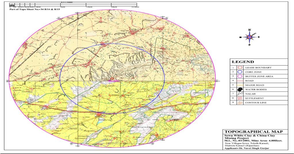
23 4.0 SITE ANALYSIS Figure 4-1: KEY Plan 19
24 4.5 EXISTING INFRASTRUCTURE Refer the para no. 4.1 of section Site Analysis WATER The total water demand will be as follows: Daily Water Demand 6.32 KLD Domestic 0.52 KLD Dust Suppression 2.0 KLD Plantation 3.8 KLD BASIC AMENITIES a) School:-The Primary school & High school facility is available at Sewa (3.0Km, NW). b) Hospital: - Nearest dispensary is located at Sewa 3.0Km NW of lease area while hospital is available at Karauli (15.0 Km, NW). 4.6 SOIL CLASSIFICATION Soils of the district are classified as: Loamy sand to sandy loam Sandy clay loam Sandy clay 4.7 CLIMATE The climate in the region shows broadly four seasonal variations, namely: Winter: December - February Summer: March Mid June Monsoon: Mid June - September Post-monsoon: October November 20
25 4.0 Site Analysis Information presented in subsequent paragraphs is from the Indian Meteorological Department (IMD), Long Term Climatological Tables, , Sawai Madhopur. These tables give useful information about a region s weather, since they are collected over a 30-year period Temperature May is the hottest months of the year mean daily maximum temperature recorded is 45.9 C and a minimum of 21.4 C. Highest temperature ever recorded at Sawai Madhopur is 48.0 C on 24 th & 13 th of May & June 1983 respectively. During winter season mean daily minimum temperature drops down to -1.0 C in the month of January, the lowest temperature ever recorded at Bhilwara is -1.0 C on 20 th of January During the post-monsoon months of October and November mean daily maximum mean daily minimum temperatures remain between ºC Wind Long- term wind direction data is presented in Table 4 5: and give its reference and indicates that the predominant wind during the summer season is (March- May) North- West winds at daytime as well as evening time. During monsoon season also the first predominant wind direction is Clam winds, second predominant is observed to be West direction, during winter season also the first predominant is calm wind and second predominant being West again. Predominant Wind Direction Table 4-6: Wind Direction as per Climatological Table of IMD First Predominant Wind Direction Second Predominant wind Direction 21 Third Predominant wind Direction Month Morning Evening Morning Evening Morning Evening January Calm Calm N/NE North South West North East February Calm Calm N/SW North NW/NE North West March Calm North South West Calm North West West April Calm North South West Calm West West West May Calm North West West South West North West June Calm North West West North West N/SW
26 4.0 Site Analysis West July Calm Calm West West SouthWest SouthWest August Calm Calm W/SW West NorthWest SouthWest September Calm Calm SouthWest W/NW West N/SW October Calm Calm SouthWest North S/W NorthWest November Calm Calm SouthWest North North/West NE/NW December Calm Calm SouthWest North North NorthEast Humidity: Most humid conditions are found in the monsoons, followed by summer, post-monsoons, and winter in that order. Mornings are more humid than evenings and humidity ranges from a high of 84-75% in monsoon mornings to a low of 35.56% in winter evenings. During post-monsoon season, in morning humidity remains between % and in the evening it remains between47-42% Rainfall: The total rainfall in a year is observed to be mm. Distribution of rainfall by season is 25.9 mm in winter (December, January, February), 27.2 mm in summer (March, April, May), approximately 88% of the total rainfall i.e mm in monsoons (June, July, August, September) and 42.7 mm in post-monsoons (October November) 4.8 SOCIAL INFRASTRUCTURE AVAILABLE The social infrastructure available in the study area is given in Table below. Table 4-7: SOCIAL INFRASTRUCTURE Particulars Name Distance (Km) Direction (From Mine Area) Nearest Habitation Karauli 15 Km NE Nearest Town Karauli 15 Km NE Nearest Airport Jaipur 111 Km North-West Nearest Highway SH 3.0 NW Nearest Station Railway Choti Udai 8.0 Km NW Nearest Dispensary Karauli 15 Km NE Educational Facility Karauli 15 Km NE 22
27 5.0 Planning Brief S. No. Human 5 PLANNING BRIEF 5.1 PLANNING CONCEPT Type of Industry: Mining of White Clay/ China Clay Facilities: Drinking water, first aid, mine office, rest shelter Transportation: White Clay/China Clay will be transported by means of Dumpers Town and Country Planning Development Authority Classification: not applicable, since this is a mining 5.2 PROJECTPOPULATION PROJECTION Settlement In the Buffer zone, total household is Total population is out of which, 8892 are males and 7597 are females. The total literate person in the surrounding area is 8268 and total worker s population is The detailed demographic profile of villages located in the study area is given below:- Table 5-1: Demographic Profile Total Total Total Total Total Total Total Total Non- House Hold Population Male Female Literates Illiterates worker Worker 1 Manderoo Bholooki Kothi Nangal Sultanpur Bhandari Berooni Bindapura Jagatpura Bharka Anandgarh Rundi Rampur Palan Doondipura Paharpura Haroti Fatehpur Suratpura Ramthara TOTAL (Source: Census Data, 2011) 23
28 5.0 Planning Brief 5.3 LAND USE PLANNING The sapling for plantation for green belt development will be selected based on less water availability in the region and according to climatic condition and hence it is proposed to plant 760 saplings per year. The plantation will be done at the lease boundary and outside the lease area. Year- wise programme of green belt development for five years, about 760 saplings will be planted in an area of ha. Up to the conceptual phase 760 saplings will be planted. Green belt development will improve the eco-system and aesthetic beauty of the area. Post plantation care will be taken such as provision for watering, soil mulching manure supply to plants etc these activities will be taken up for plants. The list of the species to be planted in the green belt is provided below:- Table 5-2: Green belt Programme Year Area (ha.) No. of Species Place of Saplings Plantation I Babool, Salar, Boundary barrier II Neem & of the lease&in the III Khejari. lease area& Near IV By Grampanchayt, Hospital, School V etc After - -- V th Year At the end of Lease period ASSESSMENT OF INFRASTRUCTURE DEMAND (PHYSICAL AND SOCIAL) The mine area is easily accessible from the state highway by SH-1 is ~3.0km in NW direction from the mine site. These state highways will be helpful for approach of workers to the mine site as well as transportation of mineral to the nearby areas and end users. Choti Udai Railway Station at a distance of ~8 km. in NW direction from Mining Lease area. The infrastructure demand in the villages will be evaluate on the basis of necessity and priority. Job opportunities are inadequate and new possibility for income generation is required. 5.5 AMENITIES/FACILITIES Mine Office: It is proposed to have a temporary mine office with First Aid Facility. 24
29 5.0 Planning Brief Rest Shelter: Temporary Rest Shelter will be made available. Drinking Water Facility: The drinking water will be made available from the nearby open well as well as from the PHED supply of Sewa village by water tankers. It will be stored in earthen pots and tanks at the site. Toilets: The toilet facility is proposed for the better sanitary condition of the workers employed in Mining area. Other facilities will be developed as per recumbent of the local people of the local of the nearby area under corporate social responsibilities programs. Table 5-3: Break-up of Budgetary Provision for the Facilities provided for the Labours S. No. PARTICULARS CAPITAL COST RECURRING COST (P.A.) (IN RS.) 1. Shelter, Safe Drinking water, 35,000 (One Drinking water, Sanitation Facility Time) 15, Health facility -- 15, Education for Children for -- 15,000 mine employees Total 35,000/- 45, 000/- 25
30 6.0 Proposed Infrastructure 6 PROPOSED INFRASTRUCTURE 6.1 INDUSTRIAL AREA The area is well connected by road network to the mines, District headquarter etc. The area is self-sufficient to supply the needs of the project. Hence no, infrastructure is proposed. 6.2 RESIDENTIAL AREA (NON PROCESSING AREA) The local people will be employed, hence no residential area/ housing is proposed. 6.3 GREEN BELT Refer point no SOCIAL INFRASTRUCTURE The proposed project is situated at Village Sewa, Tehsil & District Karauli (Rajasthan). As local people will be employed for excavation activities, no permanent infrastructure is required. The workers will come to the site by company s vehicle. By this project, indirect means of earnings in the area will be developed, which will bring a positive impact on the adjacent habitation. 6.5 CONNECTIVITY Given in Para No DRINKING WATER MANAGEMENT (SOURCE & SUPPLY OF WATER) The total water requirement for the proposed activity is 6.32 KLD which will be met from the nearby village pond (desolation and impoundment will be carried out by P.P.). On one hand this will recharge the ground water table on the other will act as a water source nearby habitants. Only water for drinking purposes i.e KLD will be brought from nearby dug well/phed. However, rain water stored in the pit during the rainy season will be used for plantation and dust suppression. The proposed indigenous water source created by the project proponent will fulfill the water demand of local habitants. 6.7 SEWAGE SYSTEM Sewage will be disposed of in soak pit at site. 6.8 INDUSTRIAL WASTE MANAGEMENT No industrial waste will be generated. 26
31 6.0 Proposed Infrastructure 6.9 SOLID WASTE MANAGEMENT Given in point no POWER REQUIREMENT & SUPPLY/SOURCE For the proposed mining activity no power is required. If electricity is required it will be provided by the AVVNL. 27
32 7.0 Rehabilitation And Resettlement (R & R Plan) 7 REHABILITATION AND RESETTLEMENT (R & R PLAN) 7.1 POLICY TO BE ADOPTED No rehabilitation and resettlement is either required or proposed for the project as mining will be carried out entirely on Government Waste Land. 28
33 8.0 Project Schedule and Cost Estimate 8 PROJECT SCHEDULE AND COST ESTIMATES 8.1 TIME SCHEDULE FOR THE PROJECT The project will be started immediately after Environmental Clearance and other necessary approvals from concerning authorities of State Government. 8.2 ESTIMATED PROJECT COST Project cost The proposed project cost will be Rs Lac/Annum Capital Cost: Rs. 28 Lac/Annum Recurring Cost: Rs. 12. Lac/Annum 8.3 Expenditure Proposed for Environmental protection activities: It is proposed to invest an amount of Rs 1.50 Lac towards environmental action plan. The details of the same are given below: Table 8-1: Expenditure Proposed for Environmental Protection Activities S. No. Description of Item Recurring Cost (Rs) 1 Air Pollution Control - Water Sprinkling 20,000 2 Environmental Monitoring and Management 25,000 3 Green Belt Development 30,000 4 Water Pollution control 10,000 Total 85,000/- Table 8-2: ESR (Entrepreneur Social Responsibility) S. No. ESR Activity Proposed Budget ( in Lacs) 1. Proposed rain water harvesting Social Forestry (At Gram Panchayat, 0.15 Schools, Hospital) 3. Social responsibility for surrounding area 0.26 of mine site Drinking water facilities near -by Govt. Hospital, 4. Health check - up Camps for villagers as 0.21 well as mine workers Total
34 9.0 Analysis of Proposal 9 ANALYSIS OF PROPOSAL Proposed White Clay/China Clay mine project will result in growth of the surrounding areas. Direct and indirect employment will be created for local people in nearby villages as per eligibility criteria. Special emphasis on Financial and Social benefits will be given to the local People. No major adverse effect on environment is envisaged as the required mitigation measures are inbuilt in the project. 30
35 10.0 Environment Management Plan 10 ENVIRONMENT MANAGEMENT PLAN Table 10-1: below gives the environment management plan for the proposed mining project. Table 10-2: ENVIRONMENT MANAGEMENT PLAN PARTICULARS Air Quality Excavation, Loading and Transportation Water Quality Noise Quality Drilling, Blasting, Loading and MANAGEMENT Dust generated due to drilling, blasting and vehicular movements will be suppressed by water spraying on haul road. To avoid the dust generation from the drilling operations wet drilling method will be practiced. Drill machines will be fitted with dust collectors. Use of appropriate explosives for blasting. Controlled blasting techniques will be practiced. Dust mask will be provided to the workers. Proper maintenance of vehicles & machineries will be done. Water sprinkling on the haul road and other road at regular intervals will be done. Speed of the vehicles will be kept within the prescribed limits. Dumpers will not be over loaded. Sewage will be generated by employing 15 workers in the mine which will be diverted into a septic tank followed by soak pit. Garland drains will be made around the mining area to channelize surface run off into natural drainage pit so that it can be utilized for dust suppression. Mining operations will be at higher levels; therefore there will be no effect on ground water condition due to mining. Adequate silencers in all the diesel operated vehicles will be used. 31
36 10.0 Environment Management Plan unloading of Mineral Personnel protective equipment will be provided to and movement of the workers/employed persons. Trucks. Proper maintenance of machines at regular intervals will be done. Green belt development and plantation. Waste generated during mining operation will be Solid Waste stacked separately in the boundary barrier and will be stabilized by plantation. Small amount of domestic waste will be generated for which dustbin will be kept at proper place and it will be disposed properly and regularly. At the end of life of mine, total excavated area will be Land Reclamation 0.78 ha out of which ha will be converted into reservoir, ha area will be backfilled and ha area will be planted around the periphery. Environmental Management plan is enclosed as Plate No.-III. 32
INDEX 1 EXECUTIVE SUMMARY INTRODUCTION OF THE PROJECT/ BACKGROUND INFORMATION PROJECT DESCRIPTION... 32
 M.L. Area- 4.0580ha., Near Village- Indawar, Tehsil Merta, District - Nagaur (Raj.) Index INDEX 1 EXECUTIVE SUMMARY... 28 2 INTRODUCTION OF THE PROJECT/ BACKGROUND INFORMATION... 30 2.1 IDENTIFICATION
PRE FEASIBILITY REPORT. Company of production capacity: 14,40,000 CFT/ Year located at Khasra No near Village:
 PRE FEASIBILITY REPORT 1.0 EXECUTIVE SUMMARY In our Masonry Stone Mining Lease (M.L. No. 15/96, Area: 1.0 ha), Production capacity of masonry stone: 142920 TPA and existing Stone Crusher Unit named M/s.
INDEX 1 EXECUTIVE SUMMARY INTRODUCTION OF THE PROJECT/ BACKGROUND INFORMATION PROJECT DESCRIPTION... 9
 Index INDEX 1 EXECUTIVE SUMMARY... 4 2 INTRODUCTION OF THE PROJECT/ BACKGROUND INFORMATION... 7 2.1 IDENTIFICATION OF PROJECT AND PROJECT PROPONENT... 7 2.2 NEED FOR THE PROJECT & ITS IMPORTANCE TO THE
EXECUTIVE SUMMARY. 1.1 Executive Summary
 1.1 Executive Summary EXECUTIVE SUMMARY Chobe ki Guwari Sand Stone Mining Project (M.L. No- 26-R-01/2001) is situated near village Chobe ki Guwari, Tehsil Sapotra, District Karoli, State Rajasthan over
PRE FEASIBILITY REPORT
 PRE FEASIBILITY REPORT 1. Introduction 1. Identification of project and project proponent The Pahanbarri Sand Quarry area is located in the Tawa River at Village- Pahanbarri, Tehsil- Itarsi & District-
PRE FEASIBILITY REPORT
 Page1 PRE FEASIBILITY REPORT KALDA FLAG STONE QUARRY AREA OF -1.55 HACTARE STRICTLY AS PER MOEF GUIDELINE DATE 30/12/2006 IN TERMS OF PROVISIONS OF EIA NOTIFICATION 2006 VILLAGE KALDA TEHSIL PAWAI DISTRICT
PRE FEASIBILITY REPORT
 PRE FEASIBILITY REPORT Of Shri Upendra Suryawanshi At Khasra No. 413/1, 413/3 Vill.-Ambada, Tehsil-Amla, District-Betul (M.P.) Production Capacity: Max 6,320 Cu.mt/year Area 1.00Hectare Proponent Name
EXECUTIVE SUMMARY. Kumardeipur Sand Quarry Cum ' 13.3" N to 20 44' 20.7"N Longitude " E to 85 35'27.5 "E
 EXECUTIVE SUMMARY 1.0 INTRODUCTION Sri Mahesh Prasad Mishra proposes to mine Sand Quarry from an approved Mining Lease over an area of 14.85 Ac or 6.01 hectares (Non-Forest Land) which is located in at
EXISTING PROJECT FOR ORDINARY SAND MINING
 (C) PROJECT REPORT OF EXISTING PROJECT FOR ORDINARY SAND MINING OF JASHUBEN CHHAGANBHAI OAD AT VILLAGE:-TIMBA, TALUKA:- KAMREJ, DIST.:- SURAT 1 CONTENTS 1.0 INTRODUCTION 1.1 PREAMBLE 2.0 EXECUTIVE SUMMARY
Limestone Mining Project (Area: ha) at Near Village: Bhod, Taluka Ranavav, District Porbandar (Gujarat) Pre-feasibility Report
 at Near Village: Bhod, Taluka Ranavav, District Porbandar (Gujarat) Pre-feasibility Report") Limestone Mining Project (Area: 16.18 ha) at Near Village: Bhod, Taluka Ranavav, District Porbandar PRE - FEASIBILITY REPORT FOR OBTAINING PRIOR ENVIRONMENT CLEARANCE For MINING ACTIVITY CATEGORY B2 UNDER
Limestone Mining Project (Area: 16.18 ha) at Near Village: Bhod, Taluka Ranavav, District Porbandar PRE - FEASIBILITY REPORT FOR OBTAINING PRIOR ENVIRONMENT CLEARANCE For MINING ACTIVITY CATEGORY B2 UNDER
(B) PREFEASIBILITY REPORT OF EXISTING BLACK TRAP PROJECT OF
 PREFEASIBILITY REPORT OF EXISTING BLACK TRAP PROJECT OF") (B) PREFEASIBILITY REPORT OF EXISTING BLACK TRAP PROJECT OF Makwana Dineshbhai Khimjibhai AT VILLAGE:- Tithava, TALUKA:- Wankaner, DIST.:- Morbi 1 CONTENTS 1.0 INTRODUCTION 1.1 PREAMBLE 2.0 EXCUTIVE SUMMARY
(B) PREFEASIBILITY REPORT OF EXISTING BLACK TRAP PROJECT OF Makwana Dineshbhai Khimjibhai AT VILLAGE:- Tithava, TALUKA:- Wankaner, DIST.:- Morbi 1 CONTENTS 1.0 INTRODUCTION 1.1 PREAMBLE 2.0 EXCUTIVE SUMMARY
PRE- FEASIBILITY REPORT
 PRE- FEASIBILITY REPORT EXECUTIVE SUMMARY 1.0 Executive Summary The Mining lease was granted in favour of Shri Mukesh Kumar S/o Shri Harish Chandra, R/o Tatol vaya Bagra, Tehsil - Bhinmal, Dist.-Jalore
PREFEASIBILITY REPORT
 (B) PREFEASIBILITY REPORT OF EXISTING SAND MINING PROJECT OF RAJESHBHAI BHAGUBHAI PATEL AT VILLAGE:- Panchlai, TALUKA:- Pardi, DIST.:-Valdad. 1 CONTENTS 1.0 INTRODUCTION 1.1 PREAMBLE 2.0 EXECUTIVE SUMMARY
1/1, Index INDEX ANY, SHOULD
 River Sand (Minor Mineral) Mining Project for River Yamuna in Gata No. 1/1, Production (9, 47,368 TPA), M.L Area 52.63 ha, near village: Index 1 2 INDEX EXECUTIVE SUMMARY... 2 INTRODUCTION OF THE OBJECT/
PRE-FEASIBILITY REPORT. Name of Company / Mine Owner Shri Jayant Kumar Choudhary Location
 1. SUMMARY PRE-FEASIBILITY REPORT Project Stone Quarry Name of Company / Mine Owner Shri Jayant Kumar Choudhary Location Village Taluka District State Rupapali Basna Mahasamund Chhattisgarh 1 Mining Lease
Table 1.1: The Salient Features of the Project Proposed Quartz Mine Of M/s. Viswanadha Stone Crusher & 16 others
 1. EXECUTIVE SUMMARY 1.1 Introduction The Road Metal Quarries was granted in Guntur District, Andhra Pradesh has been allotted to M/s. Viswanadha Stone Crusher & 16 others by Assistant Director of Mines
SRI K. RAVI SHANKAR SURVEY NO.100, ODULAPALLI VILLAGE, TALPULA MANDAL, ANANTHAPURAMU DISTRICT, ANDHRA PRADESH
 SRI K. RAVI SHANKAR SURVEY NO.100, ODULAPALLI VILLAGE, TALPULA MANDAL, ANANTHAPURAMU DISTRICT, ANDHRA PRADESH PRE FEASIBILITY REPORT (OPENCAST QUARTZ MINE 40.313 ha) SUBMITTED BY Sri Door No. 39/49/39,
Pre-Feasibility Report for Girgita Limestone Mine of M/s KJS Cements Ltd.)
") Pre-Feasibility Report for Girgita Limestone Mine of M/s KJS Cements Ltd.) 1) Executive Summary Project Name of Company / Mine Owner Location Village Taluka District State Girgita Limestone Mine M/s KJS
Pre-Feasibility Report for Girgita Limestone Mine of M/s KJS Cements Ltd.) 1) Executive Summary Project Name of Company / Mine Owner Location Village Taluka District State Girgita Limestone Mine M/s KJS
PREFEASIBILITY REPORT OF EXISTING SILICA SAND MINING PROJECT OF MANGUBEN KANTILAL THAKKAR
 PREFEASIBILITY REPORT OF EXISTING SILICA SAND MINING PROJECT OF MANGUBEN KANTILAL THAKKAR AT VILLAGE:- BRAHMPURI, TALUKA:- Sayla, DIST.:-Surendranagar 1 CONTENTS 1.0 INTRODUCTION 1.1 PREAMBLE 2.0 EXECUTIVE
Masonry Stone Mining Project, M. L. No. 27/09, M. L. Area 1.0 ha. Near Village: Velangri, Tehsil & District-Sirohi (Rajasthan) PRE FEASIBILITY REPORT
 PRE FEASIBILITY REPORT") 1.0 EXECUTIVE SUMMARY PRE FEASIBILITY REPORT This is an existing mine, proposal for obtaining Environmental Clearance for Masonry Stone with production capacity 37,300 TPA Near Village: Velangri, Tehsil-Sirohi,
1.0 EXECUTIVE SUMMARY PRE FEASIBILITY REPORT This is an existing mine, proposal for obtaining Environmental Clearance for Masonry Stone with production capacity 37,300 TPA Near Village: Velangri, Tehsil-Sirohi,
PRE-FEASIBILTY REPORT
 Aug 2018 PRE-FEASIBILTY REPORT OF M/S. J.M.R.MINES (MINING OF FELDSPAR, QUARTZ & MICA MINE) Lease Area : 5.78 Hectares(14.29 Acres) Sy.No.941,942,943 &947 Giddalur (V), Sydapuram (M), SPSR Nellore District
MODIFIED QUARRYING PLAN FOR "SHINGATALOOR SAND MINING BLOCK-2" EXTENT Acres (4.86 Ha) IN TUNGABHADRA RIVER BED ADJ ACENT TO SY.
 IN TUNGABHADRA RIVER BED ADJ ACENT TO SY.") MODIFIED QUARRYING PLAN FOR "SHINGATALOOR SAND MINING BLOCK-2" EXTENT -12.00 Acres (4.86 Ha) IN TUNGABHADRA RIVER BED ADJ ACENT TO SY.NO - 129 & 131OF SHINGATALOOR - VILLAGE MUNDARGI - TALUK GADAG - DISTRICT
MODIFIED QUARRYING PLAN FOR "SHINGATALOOR SAND MINING BLOCK-2" EXTENT -12.00 Acres (4.86 Ha) IN TUNGABHADRA RIVER BED ADJ ACENT TO SY.NO - 129 & 131OF SHINGATALOOR - VILLAGE MUNDARGI - TALUK GADAG - DISTRICT
PRE-FEASIBILITY REPORT
 M/S. VANAS INFRA PROJECTS PVT. LTD SURVEY NO. 598, CHINTALAPALLY VILLAGE, KOLLAPUR MANDAL, NAGARKURNOOL DISTRICT, TELANGANA PRE-FEASIBILITY REPORT SUBMITTED BY M/s. Sri Soma Jitendra H. No. 7-1-397/150,
PRE FEASIBILITY REPORT
 1.0 EXECUTIVE SUMMARY PRE FEASIBILITY REPORT The proposal for obtaining Environmental Clearance for Marble Mining Project M. L. No. 56/02, Area 4.0 ha with production capacity 40,000 TPA Near Village:
Table 1.1: The Salient Features of the Project. Proposed Quartz Mine Of Sri. Syed Masthan Basha
 1. EXECUTIVE SUMMARY 1.1 Introduction The Eknampuram Quartz mine of 89.80 Acres/ 36.34 ha is located in Sy. No. 60, Eknampuram Village, C.S. Puram Mandal, Prakasam District, Andhra Pradesh has been allotted
PREFEASIBILITY REPORT FOR BRICK EARTH MINE
 Page 1 PREFEASIBILITY REPORT FOR BRICK EARTH MINE Developed By- Village-Chandauhan, Tehsil-Phulpur, District-Allhabaad, Uttar Pradesh. RAI ENVIROMENTAL SERVICES PVT. LTD. Website: www.raienviro.com Email
ENVIRONMENTAL MANAGEMENT PLAN FOR DALPATPUR STONE QUARRY AT VILLAGE DALPUTPUR TEHSIL KHURAI AND DISTRICT SAGAR [MP], AREA (0.
![ENVIRONMENTAL MANAGEMENT PLAN FOR DALPATPUR STONE QUARRY AT VILLAGE DALPUTPUR TEHSIL KHURAI AND DISTRICT SAGAR [MP], AREA (0.](/thumbs/89/98680935.jpg "ENVIRONMENTAL MANAGEMENT PLAN FOR DALPATPUR STONE QUARRY AT VILLAGE DALPUTPUR TEHSIL KHURAI AND DISTRICT SAGAR [MP], AREA (0.") ENVIRONMENTAL MANAGEMENT PLAN FOR DALPATPUR STONE QUARRY AT VILLAGE DALPUTPUR TEHSIL KHURAI AND DISTRICT SAGAR [MP], AREA (0.920ha) 1.1 Introduction The subject quarry is proposed for metal stone on 0.920
ENVIRONMENTAL MANAGEMENT PLAN FOR DALPATPUR STONE QUARRY AT VILLAGE DALPUTPUR TEHSIL KHURAI AND DISTRICT SAGAR [MP], AREA (0.920ha) 1.1 Introduction The subject quarry is proposed for metal stone on 0.920
ENVIRONMENT MANAGEMENT PLAN
 ENVIRONMENT MANAGEMENT PLAN OF ALAMPUR THIKARIYA SAND DEPOSIT QUARRY KHASRA NO. 149, TOTAL AREA- 8.0 Hect. (MALENI RIVER) AT VILLAGE- ALAMPUR THIKARIYA, TEHSIL-JAORA, DISTRICT- RATLAM, STATE-MADHYA PRADESH
Pre- Feasibility RepoRt
 Pre- Feasibility RepoRt AREA- 59.28 ACRE (24.0 HA) FOR KEN RIVER SAND/MORRUM MINING AT BLOCK NO-09 KHAND NO-03 GATA NO-337 VILLAGE- KANWARA TEHSIL-BANDA, DISTRICT- BANDA(U.P) SHRI RAVINDRA NATH SINGH JULY
EIA-EMP REPORT GRAVEL QUARRY (Category-B2)
") EIA-EMP REPORT GRAVEL QUARRY (Category-B2) EXTENT : 4.00.0 Hectares S. F. No : 436/1A (P) VILLAGE TALUK DISTRICT STATE : IYANPAPPAKKUDI : MADURAI : MADURAI : TAMIL NADU PROJECT PROPONENT Thiru P. Ayyanar
EIA-EMP REPORT GRAVEL QUARRY (Category-B2) EXTENT : 4.00.0 Hectares S. F. No : 436/1A (P) VILLAGE TALUK DISTRICT STATE : IYANPAPPAKKUDI : MADURAI : MADURAI : TAMIL NADU PROJECT PROPONENT Thiru P. Ayyanar
PROJECT BRIEF. Noise environment: No Entrant noise generation sources exist in and around project area.
 PROJECT BRIEF PROJECT LOCATION: - Pahar Kua Marble Range Mining Project Q L No 235 is located near village Pahar Kua, Tehsil Makrana., District Nagaur Rajasthan. Project is approachable from national highway.
ENVIRONMENT MANAGEMENT PLAN
 ENVIRONMENT MANAGEMENT PLAN At Narmada River Mining Project:-Category B2 Lease Area: 20.000 Hect. Khasra No. 735 Vill.-Boras, Tehsil- Udaipura District- Raisen (M.P) Project Proponent M/s Shiva Corporation
PRE FEASIBILITY REPORT
 PRE FEASIBILITY REPORT GRANITE BUILDING STONE QUARRY MINING PROJECT STATE : KERALA DISTRICT : KANNUR THALUK : THALASSERY VILLAGE : THRIPPANGOTTUR BLOCK NO. : NIL SURVEY NO. : 275/1A MINERAL : GRANITE BUILDING
Table 1.1 : Salient features of the project. Sy. No. 379/1, Perecherla Village, Medikonduru Mandal, Guntur District, Andhra Pradesh.
 1.0 EXECUTIVE SUMMARY 1.1 Introduction Road Metal of M/s. Lakshmi Stone Crusher covering an extent of 2.10 Ac is located at Sy. No. 379/1 of Perecherla Village, Medikonduru Mandal, Guntur District, Andhra
STONE QUARRY Survey No. : 57/5, Village : Dhadhade, Tehsil: Vikramgad, District Thane, Maharashtra Area (2.0 Ha)
") Pre Feasibility Report On STONE QUARRY Survey No. : 57/5, Village : Dhadhade, Tehsil: Vikramgad, District Thane, Maharashtra Area (2.0 Ha) Submitted to MINISTRY OF ENVIRONMENT & FOREST STATE LEVEL ENVIRONMENTAL
Pre Feasibility Report On STONE QUARRY Survey No. : 57/5, Village : Dhadhade, Tehsil: Vikramgad, District Thane, Maharashtra Area (2.0 Ha) Submitted to MINISTRY OF ENVIRONMENT & FOREST STATE LEVEL ENVIRONMENTAL
PRE FEASIBILITY REPORT
 1.0 EXECUTIVE SUMMARY PRE FEASIBILITY REPORT This is an existing mine. Proposal for obtaining Environmental Clearance for marble with production capacity 72860 TPA Near Village: Sankotra, Tehsil-Jamwa
2. PRE-FEASIBILITY REPORT
 2. PRE-FEASIBILITY REPORT 2.1 Executive Summary Sri D. Ujjinappa has applied for quarry lease for extracting of Building stone in Sy No. 19/2, Chatnihalli Village, Harpanahalli Taluk, Davangere District,
Pramod S. Kambli. Page 1
 PREFEASIBILITY STUDY FOR SHREE. PRAMOD S. KAMBLI Page 1 Executive summary Shree.., has laterite stone quarry in an area 2.61 Ha in the survey No. 1091 With quarrying capacity of 10259.31 TPA. The major
EXECUTIVE SUMMARY 1.0 PROJECT DESCRIPTION 1.1 INTRODUCTION
 EXECUTIVE SUMMARY 1.0 PROJECT DESCRIPTION 1.1 INTRODUCTION Jaypee Group is a leading Business House of the country with its presence in Core industries and Service Sectors like Cement, Infrastructure development,
ENVIRONMENT MANAGEMENT PLAN
 ENVIRONMENT MANAGEMENT PLAN OF Shri Krishna Construction Company AT Khasra No.1046 Vill.-Pipalya Hamir, Tehsil-Barod, District-Agar Malwa (M.P.) Production Capacity: 40000 Cu.mt Crusher Stone for 18 Months
PRE-FEASIBILITY REPORT
 PRE-FEASIBILITY REPORT Motawatan Ball Clay Mine, M.L. No. 20/2003, Production Capacity 1,01,676.6 MTPA, M.L. Area-80.94 ha., Index INDEX 1 EXECUTIVE SUMMARY... 4 2 INTRODUCTION OF THE PROJECT/ BACKGROUND
PRE-FEASIBILITY REPORT FOR ORDINARY SAND
 PRE-FEASIBILITY REPORT FOR ORDINARY SAND Proponent NISANT TRADERS At- Opp. Survey No.- 3 Panam River Area-2.50.00 Hectare Village-Ramji-ni-Nal, Taluka- Shahera Dist.- Panchmahal Mob.- +91924040782 CONTENTS
PRE-FEASIBILITY REPORT. 1. SUMMARY Kudeli Brick Earth Quarry Name of Company / Mine Owner Smt. Premawati Location 744, 760/1, 760/4, 750/1, 750/2
 PRE-FEASIBILITY REPORT 1. SUMMARY Project Kudeli Brick Earth Quarry Name of Company / Mine Owner Smt. Premawati Location 744, 760/1, 760/4, 750/1, 750/2 Village Kudeli Taluka Baikunthpur District Koriya
PRE-FEASIBILITY REPORT OF SAND QUARRY
 PRE-FEASIBILITY REPORT OF SAND QUARRY Survey No Village Taluka District Lease area : 1 Paiki : Marigana : Anjar, : Kutch, Gujarat, : 2.00 Ha. Submitted to MINISTRY OF ENVIRONMENT & FORESTS STATE LEVEL
2. PRE-FEASIBILITY REPORT
 2. PRE-FEASIBILITY REPORT 2.1 Executive Summary Smt. J N Rukmini, has applied for extracting of Building stone in Sy No. 40, Kuroda Bore Kavala village, Hassan Taluk & District, Karnataka over an extent
PRE FEASIBILITY REPORT
 PRE FEASIBILITY REPORT FOR AMJHAR LATERITE DEPOSIT M. L. Area 4.897 ha. In Village - Amjhar Tehsil - Amarpatan, District- Satna State - Madhya Pradesh Proposed Capacity 32256 TPA Lessee - Shri Vikram Singh
1. PRE-FEASIBILITY REPORT
 1. PRE-FEASIBILITY REPORT 1.1 Executive Summary Sri. T. Thimmegowda, has applies quarry lisence for extracting of Building Stone Quarry in Sy No. 33/2, Kurodbore Kaval village, Hassan Taluk, Hassan District,
Pre- FEASIBILITY REPORT
 Pre- FEASIBILITY REPORT In Respect Of KATIKELA RIVER SAND BED OVER 15.00 ACRES OR 6.070 HA IN VILLAGE KATIKELA, JHARSUGUDA TAHASIL OF JHARSUGUDA DISTRICT, ODISHA (For the Financial Year-2015-16 to 2019-20)
(A govt. of Kerala Undertaking)
") Annexure - 1 Basic Information Important Note: Please send the information by e-mail in word format and a signed & scanned copy to the Member Secretary prior to the EAC meeting. Please also provide a copy
Annexure - 1 Basic Information Important Note: Please send the information by e-mail in word format and a signed & scanned copy to the Member Secretary prior to the EAC meeting. Please also provide a copy
ENVIRONMENT MANAGMENT PLAN
 ENVIRONMENT MANAGMENT PLAN DETAIL OF MINE- NAME OF MINERAL SANDSTONE (FURSHI PATTHAR) MINING LEASE FOR FINISHED SANDSTONE VILLAGE PARASWAHA, TEHSEEL JABERA DISTRICT - DAMOH KHASRA NO. 22/1, AREA 1.0 HECTARE
Overburden dumps are stacked separately as per the guidelines and the same will be used for backfilling in mined out area.
 ENVIRONMENT CLEARANCE COMPLIANCE STATUS ENVIRONMENT CLEARANCE No. J-11015/406/2006-IA.II(M) dt. 13/04/2007 DHANGARWADI MINES Sr. CONDITIONS COMPLIANCE No. A) Specific Conditions :- i) Top soil to be stacked
ENVIRONMENT MANAGEMENT PLAN
 ENVIRONMENT MANAGEMENT PLAN FOR VILLAGE TEHSIL DISTRICT AREA MINERAL : Pathari Basouda : Basouda : Vidisha (M.P.) : 2.00 Hectare : Stone KHASRA No : 177/1/2 PRODUCTION CAP : 10000 Cu.mt/year Stone APPLICANT
Table 1.1 : Salient features of the project. Sy. No. 379/1, Perecherla Village, Medikonduru Mandal, Guntur District, Andhra Pradesh.
 1.0 EXECUTIVESUMMARY 1.1 Introduction Road Metal of M/s. Venkata Ramana Stone Crusher covering an extent of 0.89 Ac is located at Sy.No.379/1 of Perecherla Village, Medikonduru Mandal, Guntur District,
PRE FEASIBILITY REPORT OF KUMHARI STONE MINE, LESSEE M/s VINOD KUMAR JAIN VILLAGE KUMHARI, P.O. BASIA, P.S. BASIA, DIST. - GUMLA, JHARKHAND
 EXECUTIVE SUMMARY Kumhari Stone Mine is situated in Village - Kumhari, P.O. Basia, P.S. - Basia, District : Gumla, Jharkhand over an area of 2.02 Hectares or 5.00 Acres [ Plot no. 2085(P)]. Kumhari Stone
ENVIRONMENT MANAGEMENT PLAN FOR STONE MINING
 ENVIRONMENT MANAGEMENT PLAN FOR STONE MINING 1. Name and Address of Quarry Lease Holder: a. Name of applicant Priyesh Singh Thakur S/o Shri Karan Singh Thakur b. Designation of applicant Owner c. Name
S. No Parameter Details 1 Name & Address of the Applicant
 1. EXECUTIVE SUMMARY S. No Parameter Details 1 Name & Address of the Applicant M/s AMULYA GRANITES Prop: Smt CH.SARALA H. No. FLAT NO.207 Roja Kishore Residency, Chenchupet, Tenali, AP-522 202 Guntur District,
PRE FEASIBILITY REPORT
 PRE FEASIBILITY REPORT BANDOL CRUSHER STONE QUARRY OF SHRI TULSIRAM SAHU AT Khasra No. 15/2,23/2 Village Bandol Tehsil District State Madhya Pradesh Production Capacity 45030 M3/Year Area 3.150 Hectare
ENVIRONMENT MANAGEMENT PLAN
 ENVIRONMENT MANAGEMENT PLAN FOR VILLAGE TEHSIL DISTRICT AREA MINERAL : Parsen : Gwalior : Gwalior (M.P.) : 3.345 Hectare : Stone KHASRA No : 4154 PRODUCTION CAP : 50,000 Cu.mt/year (avg.) Stone APPLICANT
ENVIRONMENT MANAGEMENT PLAN
 ENVIRONMENT MANAGEMENT PLAN VILLAGE - KUNDLA TEHSIL - NAGDA DISTRICT - UJJAIN STATE - MADHYA PRADESH KHASRA NO. - 574 AREA - 8.00 Hectare PRODUCTION - 98800 cu.m/ Year PREPARED UNDER RULE 42 C OF MP MINOR
PRE FEASIBILITY REPORT
 PRE FEASIBILITY REPORT TABLE OF CONTENTS Sr. No. Content Page No. 1.0 Executive Summary 23 2.0 Introduction of Project and Background Information 24 3.0 Project Description 26 4.0 Site Analysis 33 5.0
PRE-FEASIBILITY REPORT
 PRE-FEASIBILITY REPORT For Excavation of Brick Earth (Total Mining Area 1.112Ha.) (For Manufacturing of Bricks) Submitted By M/s New Kaptan Brick Field Shri Krishna Kr. Singh S/o Shri Brahma DevSingh Pure
PRE FEASIBILITY REPORT. PROJECT Maharkund Manganese Ore Mine (10.62 ha) Village Maharkund; Tehsil Ramtek; District-Nagpur (MS) Project Proponent
 Village Maharkund; Tehsil Ramtek; District-Nagpur (MS) Project Proponent") PRE FEASIBILITY REPORT PROJECT Maharkund Manganese Ore Mine (10.62 ha) Village Maharkund; Tehsil Ramtek; District-Nagpur (MS) Project Proponent M/s Veet Rag Homes Pvt. Ltd. 267, Ganesh Phadnavis Bhavan,
PRE FEASIBILITY REPORT PROJECT Maharkund Manganese Ore Mine (10.62 ha) Village Maharkund; Tehsil Ramtek; District-Nagpur (MS) Project Proponent M/s Veet Rag Homes Pvt. Ltd. 267, Ganesh Phadnavis Bhavan,
PRE- FEASIBILITY REPORT INDAWAR CHINA CLAY MINE
 PRE FEASIBILITY REPORT FOR INDAWAR CHINA CLAY MINE (M.L. NO. 17/2006) PROJECT At VILLAGE INDAWAR TEHSIL MERTA, DISTRICT NAGAUR STATE RAJASTHAN Lease Area : 4.150Hect. Category of Project : B1 (Total LOI
Table 1-1:- Salient Features of the Project
 PRE FEASIBILITY REPORT OF LAMBA & BHATIA BAUXITE MINE MINERALS - BAUXITE LAMBA SURVEY. NO. 30/P, 415/A, 949, BHATIA-358 (LEASE PERIOD 14.06.2000 TO 13. 06.2020) LEASE AREA 54.0861 HECTARE MINING PROJECT
ME/JALORE/MM/ML/13/13/4059 Dated 13/01/2014.
 1.0 EXECUTIVE SUMMARY This is an fresh mining lease of mineral Granite located near Village-Valdara, Tehsil Ahore, District Jalore, Rajasthan. over an area of 3.0 hectares. LOI has been issued in favor
Environment Management Plan
 Environment Management Plan Environmental Impact Assessment Statement describing the impact of mining and beneficiation on environment on the following: i) Land area indicating the area likely to be degraded
PRE FEASIBILITY REPORT For SILICA SAND MINE. At Village- Karlapudi, Tehsil- Kota, Nellore, Andhra Pradesh ha.
 PRE FEASIBILITY REPORT For SILICA SAND MINE At Village- Karlapudi, Tehsil- Kota, Nellore, Andhra Pradesh 11.797 ha. Project Proponent Sri Yashpal Mendon 1 st Floor Mineral House, Hampankatta, Mangalore
PRE-FEASIBILITY REPORT
 PRE-FEASIBILITY REPORT 1.0 EXECUTIVE SUMMARY M/s Arti Chemical Industries is a project located at Plot No. E-22, Vilayat G.I.D.C. Tal: Vagra area of Bharuch district in Gujarat. M/s Arti Chemical Industries
Pre-Feasibility Report
 Pre-Feasibility Report 1. Executive Summary Residential, Commercial, Retail and Hotel projects and an IT/ITES. The Project has already obtained an Environmental Clearance from Ministry of Environment &
PRE FEASIBILITY REPORT
 PRE FEASIBILITY REPORT for PROPOSED PROJECT FOR DYES, PIGMENTS AND DYE INTERMEDIATES MANUFACTURING PLANT IN GIDC, DAHEJ-II Of M/s. SHREEJI INDUSTRIES Plot No. D2/CH/24, Dahej-II, GIDC Industrial Estate,
Project Proponent: Shri Kuldeep Pratap Singh Bhati Page - 11
 1.0 EXECUTIVE SUMMARY This is a new mining lease of Ball Clay Silica Sand, M.L. No.- 48/2011, located near Village- Indo Ka Bala, Tehsil-Kolayati, District Bikaner (Rajasthan) over an area of 4.2464 hectares.
PRE-FEASIBILITY REPORT
 PRE-FEASIBILITY REPORT For M/s. Shah Shah Mines & Minerals, SY. NO. 206/1, Gangireddipalli Village, Thamballapalli Mandal, Chittoor District, Andhra Pradesh. INDEX ITEM PAGE NO. 1. EXECUTIVE SUMMARY 3
PRE FEASIBILITY REPORT OF KANIYAKULAM EARTH QUARRY
 PRE FEASIBILITY REPORT OF AZHAGAPPAPURAM EARTH FOR OVER AN EXTENT OF 0.61.0HA IN AZHAGAPPAPURAM VILLAGE, AGASTEESWARAM TALUK, KANNIYAKUMARI DISTRICT, TAMIL NADU OF, (Under the Guidelines of Ministry of
PRE-FEASIBILTY REPORT SUNATHAR STONE QUARRY. VILLAGE: Sunathar. TAHASIL: Purushottampur. DIST: Ganjam LESSEE SRI KAPILA CHANDRA SAHU
 PRE-FEASIBILTY REPORT OF SUNATHAR STONE QUARRY VILLAGE: Sunathar TAHASIL: Purushottampur DIST: Ganjam LESSEE SRI KAPILA CHANDRA SAHU Vill/Po- Gandala, P.S.- Hinjili, Dist.-Ganjam Odisha. CONTENTS CHAPTER
PRE FEASIBILITY REPORT FOR. Silica Sand Beneficiation Plant
 PRE FEASIBILITY REPORT FOR Silica Sand Beneficiation Plant BY Shree Silicaam Minerals LLP VILLAGE : CHOKI TALUKA : JAGADIA DIST : BHARUCH GUJARAT (INDIA) PRE-FEASIBILITY REPORT: SILICA SAND BENIFICIATION
PRE-FEASIBILIY REPORT
 BENDRI LIMESTONE QUARRY NO. - 4 3 (Quarry No. 1) (Quarry No. 1)MINERALS - DOLOMITE (LEASE PERIOD 20.05.2002 TO 19. 05.2022) LEASE AREA - 42.754 HECTARES MINING PROJECT - CATEGORY- B PRE-FEASIBILIY REPORT
Environmental Management Plan. For Mining of. Building Stone & Road Metal Over an extent of 0.56 Ha at Survey No: 493 Kannala Village,
 Environmental Management Plan For Mining of Building Stone & Road Metal Over an extent of 0.56 Ha at Survey No: 493 Kannala Village, Palakurthy Mandal, Peddapally District, Telangana State Applicant Sri
ENVIRONMENT MANAGEMENT PLAN
 ENVIRONMENT MANAGEMENT PLAN ENVIRONMENT MANAGEMENT PLAN 1.0. INTRODUCTION: The proposed M/s. Ordinary sand Mine of Shree Ramjibhai samjibhai Gujarati Area at near village Survey No.Bhadar River Bed, Vill.
EXECUTIVE SUMMARY 1.0 MADHYA PRADESH STATE MINING CORPORATION LTD
 EXECUTIVE SUMMARY 1.0 MADHYA PRADESH STATE MINING CORPORATION LTD Madhya Pradesh State Mining Corporation Ltd (MPSMCL), a company of Government of Madhya Pradesh has been allotted Amelia (North) Coal Mining
PREFEASIBILITY REPORT OF EXISTING BENTONITE PROJECT OF
 PREFEASIBILITY REPORT OF EXISTING BENTONITE PROJECT OF TRICHEMIN ASSOCIATES AT VILLAGE:- SATAPAR, TALUKA:- KALYANPUR, DIST.:- DEVBHUMI DWARKA 1 CONTENTS 1.0 INTRODUCTION 1.1 PREAMBLE 2.0 EXECUTIVE SUMMARY
BRIEF SUMMARY OF THE PROJECT
 BRIEF SUMMARY OF THE PROJECT This proposal of Nuagaon Iron ore mines of M/s K.J.S.Ahluwalia is for expansion of Iron ore production capacity from 5.62 MTPA to 7.99MTPA of ROM along with existing beneficiation
Riverbed Sand/Morrum Mining at Gata No. 747/16, Village- Patharehta, Tehsil- Kalpi, District- Jalaun, U.P. Area: 22 Acres (8.
 PRE-FEASIBILITY EXECUTIVE SUMMARY Shri Vishwas Parmani S/o Shri H. Parmani is the lessee for the RBM (River Betwa) for an area of 22 Acres (8.90 Ha) in Gata No. 747/16,Village- Patharehta, Tehsil- Kalpi,
PRE FEASIBILITY REPORT OF ANAIMALLUR ROUGH STONE QUARRY LEASE APPLIED AREA FOR OVER AN EXTENT OF
 PRE FEASIBILITY REPORT OF ANAIMALLUR ROUGH STONE QUARRY LEASE APPLIED AREA FOR OVER AN EXTENT OF 0.80.0Ha IN ANAIMALLUR VILLAGE, ARCOT TALUK, VELLORE DISTRICT, TAMILNADU OF THIRU.R.VINOTHKUMAR, (Under
EXECUTIVE SUMMARY. 1.2 SALIENT FEATURES OF THE PROJECT The mine lease area falls under the Toposheet No. 65 N/11 bearing following Toposheet details:
 2015 PRE-FEASIBILITY REPORT (FOR TOR) OF GADABAVALASA MANGANESE ORE MINES, AT: GADABAVALASA, GARIVIDI MANDAL, DIST: VIZIANAGRAM FOR PRODUCTION OF 12,000TPA OF MANGANESE ORE OVER AN AREA OF 12.691 HA. OF
M/S Overseas Min-Tech Consultants, Jaipur
 ML Area 2.1151 ha., Near Village: Gundoj, Tehsil- Pali, District- Pali Index INDEX 1 EXECUTIVE SUMMARY... 20 2 INTRODUCTION OF THE OBJECT/ BACKGROUND INFORMATION... 22 2.1 IDENTIFICATION OF PROJECT AND
INDEX. S. No. Item Page No. 1 EXECUTIVE SUMMARY 3 2 INTRODUCTION OF THE PROJECT / BACKGROUND
 PRE-FEASIBILITY REPORT PREPARED FOR D. SESHA REDDY [Mine Lease Area 3.253 Ha.] Sy. No. 12/D Nagarur Village, Yadiki Mandal, Ananthapur District, Andhra Pradesh. PREPARED BY ISO 9001: 2008 Certified Accredited
ENVIRONMENTAL MANAGEMENT REPORT COLOUR GRANITE MINE
 ENVIRONMENTAL MANAGEMENT REPORT Of COLOUR GRANITE MINE Sy. No.Old: 52/2B1 (New 52/2B1) of Peddavelagatur Village, Peddapanjani Mandal,Chittor District, Andhra Pradesh AREA OF MINING LEASE 5.70 Ha. For
Proposed Project of Halcyon Labs Pvt Ltd D-2/CH : 335,336,337, GIDC-Dahej-2, DIst: Bharuch, Gujarat Ramans Enviro Services Pvt Ltd Ahmedabad
 1. EXECUTIVE SUMMARY OF THE PROJECT BRIEF SUMMARY OF THE PROJECT : TYPE OF PROJECT : Proposed Project for manufacturing of pharma intermediates by Halcyon Labs Pvt.Ltd. LOCATION : Proposed Project of Halcyon
PRE FEASIBILITY REPORT
 PRE FEASIBILITY REPORT For PROPOSED EXPANSION OF BAKELITE POWDER MANUFACTURING UNIT of M/S. HINDUSTAN BAKELITE COMPANY PLOT NO. J-3436, GIDC ESTATE, ANKLESHWAR, DISTRICT: BHARUCH-393002, GUJARAT 0 CONTENTS
MCDR INSPECTION REPORT
 1 MCDR INSPECTION REPORT General SN Particulars Details Date of Inspection 18.10.2016 1 Name of the Mine Dhobitola Titaniferous Iron Ore Mine 2 Total Lease Area (Ha) 2.61 Ha (Entire Forest Land) with breakup
M/s. Bharat Clays Private Limited Pre-Feasibility Report
 1. EXECUTIVE SUMMARY 1.1 Introduction is a private partnership firm. They applied for a mining lease for China Clay over an extent of 2.023 Hectares in Sy. No: 102/3 & 102/4P of Jaggampeta Village, Jaggampeta
MCDR INSPECTION REPORT S/ No. 1 Name of the Mine Navalutti Iron Ore Mine 2 Total Lease Area (Ha) with breakup of Non-forest & forest land
 with breakup of Non-forest & forest land") MCDR INSPECTION REPORT S/ No. Particulars Details 1 Name of the Mine Navalutti Iron Mine 2 Total Lease Area (Ha) with breakup of Non-forest & forest land 32.40Ha (excluding 2.0 Hect. of road). Complete
MCDR INSPECTION REPORT S/ No. Particulars Details 1 Name of the Mine Navalutti Iron Mine 2 Total Lease Area (Ha) with breakup of Non-forest & forest land 32.40Ha (excluding 2.0 Hect. of road). Complete
INDEX S.NO ITEM PAGE NO 1. INTRODUCTION 3 2. DETAILS ABOUT THE MINE LEASE AREA 4 3. MINING ACTIVITY 5 4. ENVIRONMENTAL MANAGEMENT PLAN 8
 M/s. Nandini Mineral Industries (Mine Lease Area 4.120 Ha.) Sy. Nos. 105, 105/1, 2 & 113/1A Kolumulapali Village, Bethamcherla Mandal, Kurnool District, ENVIRONMENTAL MANAGEMENT PLAN PREPARED BY ISO 9001:
PRE-FEASIBILITY REPORT
 PRE-FEASIBILITY REPORT For ToR of Proposed Project of MANUFACTURING OF SYNTHETIC ORGANIC DYES (5 f B IND II) By SHREEJI BAPA DYE CHEM PLOT NO 1319 & 1320, PHASE-III, GIDC, VATVA, AHEMADABAD-382445, GUJARAT,
DHANWADA CRUSHER STONE QUARRY
 ENVIRONMENT MANAGEMENT PLAN FOR Mining of Crusher Stone Area 1.910 Hect, Kh. No. 95 AT Village: Dhanwada, Tehsil: Khirkiya, Dist: Harda (MP) Proponent Shri Atul Kumar Agrawal S/o- Shri Ashok Agrawal Resi-
Salient features of the Project. S. No. A. Mining Lease Details. iii Mining Lease Number M.L. No 20/2004. iv Mining Lease Area
 PRE FEASIBILITY REPORT 1.0 EXECUTIVE SUMMARY This is an existing mine, proposal of obtaining Environmental Clearance with production capacity 196800 TPA Near Village: Modi, Tehsil: Khetri, District: Jhunjhunu.
PRE-FEASIBILITY REPORT. 5.0 Hectare sand mine under bhu-jal
 1.0 SUMMARY OF THE PROJECT PRE-FEASIBILITY REPORT Project Name of Company / Mine Location Village Taluka District State Sand mine Gram Panchayat Tarrighat, Sand mine Tarrighat Tarrighat Patan Durg Chhattisgarh
RCCPL Private Limited (formerly known as Reliance Cement Company Private Limited) : Dithora, Sannehi Singti and Karaundi
 : Dithora, Sannehi Singti and Karaundi") Pre-Feasibility Report (As per MoEF Letter No. J011013/41/2006-IA.II (I) dated 30 th December 2010) 1. Executive Summary Project : Bigodi Limestone Mine Project Proponent : RCCPL Private Limited (formerly
Pre-Feasibility Report (As per MoEF Letter No. J011013/41/2006-IA.II (I) dated 30 th December 2010) 1. Executive Summary Project : Bigodi Limestone Mine Project Proponent : RCCPL Private Limited (formerly
APPENDIX- I FORM- 1. (I) Basic Information:
 Basic Information:") (I) Basic Information: APPENDIX- I FORM- 1 Item Details 1. Name of Project Sand Stone Mining Project, M.L..-08/1987, Area 150.926 Ha., located n/v -Gubrenda, Tehsil -Karauli, District Karauli, (Rajasthan)
(I) Basic Information: APPENDIX- I FORM- 1 Item Details 1. Name of Project Sand Stone Mining Project, M.L..-08/1987, Area 150.926 Ha., located n/v -Gubrenda, Tehsil -Karauli, District Karauli, (Rajasthan)
Scrutiny comments on examination of FMCP ( lease expiring on 31/03/2020 )of Teherai Iron and Manganese Mine of M/s Bonai Industrial Co.
of Teherai Iron and Manganese Mine of M/s Bonai Industrial Co.") Scrutiny comments on examination of FMCP ( lease expiring on 31/03/2020 )of Teherai Iron and Manganese Mine of M/s Bonai Industrial Co. Limited GENERAL: 1. Lease number and lease period since execution
Scrutiny comments on examination of FMCP ( lease expiring on 31/03/2020 )of Teherai Iron and Manganese Mine of M/s Bonai Industrial Co. Limited GENERAL: 1. Lease number and lease period since execution